- Minnesota State Highway 76
-
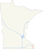
Trunk Highway 76
Highway 76 highlighted in redRoute information Defined by MS § 161.115(7) Maintained by Mn/DOT Length: 36.767 mi[1] (59.171 km) Existed: 1933 – present Major junctions South end:  IA 76 at the Iowa state line
 MN 44 at Caledonia
 MN 16 at Houston
North end:  I-90,
I-90,  CR 12
CR 12
at Pleasant Hill TownshipLocation Counties: Houston, Winona Highway system Minnesota Trunk Highways
Interstate • U.S. • State
Inter-County • County roads • Legislative routes←  US 75
US 75MN 77  →
→Minnesota State Highway 76 is a highway in southeast Minnesota, which runs from Iowa Highway 76 at the Iowa state line (near Eitzen), and continues north to its northern terminus at its interchange with Interstate Highway 90 in Pleasant Hill Township near Winona.
Highway 76 is 37 miles (60 km) in length.
Contents
Route description
Highway 76 serves as a north–south route in southeast Minnesota between Caledonia, Houston, and Interstate 90.
The route passes through the Richard J. Dorer State Forest.
Beaver Creek Valley State Park is located 4 miles west of the junction of Highway 76 and Houston County Road 1 at Caledonia. The park entrance is located on County Road 1.[2]
Highway 76 parallels State Highway 26 and State Highway 43 throughout its route.
The route is legally defined as Legislative Route 76 in the Minnesota Statutes.[3]
History
Highway 76 was authorized in 1933.[4]
By 1953, only the section in Houston County was paved. All of Highway 76 was paved by 1963.[4]
Major intersections
County Location Mile[1] Destinations Notes Iowa-Minnesota state line 0.000 Iowa 76Houston Caledonia Township 7.897 MN 44South end of MN 44 overlap Caledonia MN 44: 52.833  CR 3
CR 3Old MN 249 10.970 MN 44North end of MN 44 overlap 11.711  CR 1
CR 1Caledonia Township 12.725 CR 10 Sheldon Township 20.706 CR 4 Houston Township 22.192 MN 16East end of MN 16 overlap Houston 23.076 MN 16West end of MN 16 overlap Houston Township 23.565 CR 9 Winona Pleasant Hill Township 36.761-36.875 I-90Interchange 36.909 CR 121.000 mi = 1.609 km; 1.000 km = 0.621 mi
Concurrency terminus • Closed/Former • Incomplete access • UnopenedReferences
- ^ a b "Trunk Highway Log Point Listing - Construction District 6" (PDF). Minnesota Department of Transportation. August 23, 2010. http://www.dot.state.mn.us/roadway/data/reports/logpoint/d6.pdf. Retrieved November 1, 2010.
- ^ Minnesota DNR website for Beaver Creek Valley State Park - Link
- ^ "161.115, Additional Trunk Highways". Minnesota Statutes. Office of the Revisor of Statutes, State of Minnesota. 2010. https://www.revisor.mn.gov/statutes/?id=161.115. Retrieved November 1, 2010.
- ^ a b Riner, Steve. "Details of routes 76-100". The Unofficial Minnesota Highways Page. http://www.steve-riner.com/mnhighways/r76-100.htm#76. Retrieved November 1, 2010.[unreliable source]
Categories:- State highways in Minnesota


Wikimedia Foundation. 2010.