- Minnesota State Highway 44
-
Trunk Highway 44
Highway 44 highlighted in redRoute information Maintained by Mn/DOT Length: 35.978 mi[1] (57.901 km) Existed: 1920 – present Major junctions West end:  U.S. 52 in Canton Township
 MN 43 at Mabel
 MN 76 at Caledonia
East end:  MN 16 in Hokah
Location Counties: Fillmore, Houston Highway system Minnesota Trunk Highways
Interstate • U.S. • State
Inter-County • County roads • Legislative routes← MN 43MN 45  →
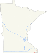
→Minnesota State Highway 44 is a highway in southeast Minnesota, which runs from its intersection with U.S. 52 in Canton Township, near Prosper, and continues east to its eastern terminus at its intersection with State Highway 16 in Hokah, near La Crescent.
Highway 44 is 36 miles (58 km) in length.
Contents
Route description
Highway 44 serves as an east–west route between Mabel, Spring Grove, Caledonia, and Hokah in southeast Minnesota.
The section of Highway 44 between Caledonia and Hokah passes through the Richard J. Dorer State Forest.
Highway 44 runs concurrent with State Highway 76 for three miles at Caledonia.
Beaver Creek Valley State Park is located near the junction of Highways 44 and 76 at the north edge of Caledonia. The park entrance is located four miles west on County Road 1 via Highway 76.[2]
History
Highway 44 was authorized in 1920. The route was paved in its entirety by 1940.[3]
The route was originally designated as an auto trail named the Southern Minnesota Air Line in a 1919 application. The Southern Minnesota Air Line continued west from Preston to the South Dakota state line on a route that later followed old U.S. Highway 16.[4]
At one time, Highway 44 had continued farther west, extending over what is now County Highway 44 in Fillmore County. The section of present day County 44 between Harmony and U.S. Highway 63 (south of Spring Valley) was designated Highway 44 between 1972 and 1995.
Major intersections
County Location Mile[1] Destinations Notes Fillmore Canton Township 29.937 US 52Newburg Township 35.315 CR 28 Mabel 35.382 MN 43Houston Spring Grove Township 39.322 CR 8 north 39.396 CR 8 south Spring Grove 42.379 CR 4 43.157 CR 16 (Maple Drive) Caledonia Township 50.418 MN 76South end of MN 76 overlap Caledonia 52.456 CR 12 52.833  CR 3
CR 353.595 MN 76North end of MN 76 overlap Hokah 66.348 MN 161.000 mi = 1.609 km; 1.000 km = 0.621 mi
Concurrency terminus • Closed/Former • Incomplete access • UnopenedReferences
*Steve Riner Details of Routes 26 to 50. Unofficial Minnesota Highways Page. Accessed January 21, 2008.
- ^ a b "Trunk Highway Log Point Listing - Construction District 6" (PDF). Minnesota Department of Transportation. August 23, 2010. http://www.dot.state.mn.us/roadway/data/reports/logpoint/d6.pdf. Retrieved October 20, 2010.
- ^ Minnesota DNR website for Beaver Creek Valley State Park - Link
- ^ Riner, Steve. "Details of routes 26-50". The Unofficial Minnesota Highways Page. http://www.steve-riner.com/mnhighways/r26-50.htm#44.[unreliable source]
- ^ "Southern Minnesota Air Line". October 20, 1919. http://www.dot.state.mn.us/library/southern_mn_air_line.jpg. Retrieved November 12, 2008.
Categories:- State highways in Minnesota


Wikimedia Foundation. 2010.