- North Kaibab Trail
-
This article is about the hiking trail at the north rim of Grand Canyon. For the trail from the south rim, see South Kaibab Trail.
North Kaibab Trail 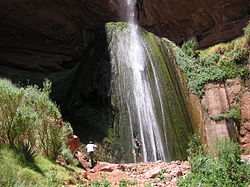
Ribbon Falls on the North Kaibab Trail Length 14 mi; 22.5 km Location Grand Canyon National Park, Arizona, United States Trailheads Phantom Ranch
Grand Canyon (North Rim)Use Hiking
Stock (Horse Use)Elevation Change 5660 ft, 1725m Highest point North Rim, 8060 ft Lowest point Colorado River, 2400 ft Trail difficulty Strenuous Season Spring through Fall Sights Grand Canyon
Colorado RiverHazards Severe Weather
Overexertion
Dehydration
Flash FloodThe North Kaibab Trail is a hiking trail in Grand Canyon National Park, located in the U.S. state of Arizona.
Contents
Access
Access to this part of the park by car is seasonal, open from mid-May to mid-October or depending on snowcover from the previous winter. It is possible to reach the North Kaibab Trailhead by crossing the canyon on foot from the South Rim or by snowshoe or cross-country ski beginning at Jacob Lake, Arizona.
Description
Mileages and features along North Kaibab Trail [1] Distance (mi) Elv (ft) Location Trail Junction Toilet Water 0 8060 Trailhead, North Rim Uncle Jim Trail
Ken Patrick TrailPortable 1.7 Supai Tunnel Composting Seasonal, Treated 5 Roaring Springs Composting Seasonal, Treated 6.9 3730 Cottonwood Campground Composting Seasonal, Treated 8.5 3888 Ribbon Falls 13.1 Trail Junction Clear Creek Trail 13.6 2545 Phantom Ranch Septic Treated 13.8 2545 Bright Angel Campground Utah Flats Route Septic Treated 14 2460 Trail Junction River Trail
South Kaibab TrailSeptic Treated The North Kaibab Trail begins at the head of Roaring Springs canyon and ends at the Colorado River.
The trailhead is at a parking area on State Route 67, about 1-mile (1.6 km) north of the North Rim's Grand Canyon Lodge. The Ken Patrick Trail and Uncle Jim Trail are also accessible from this parking area.
The trail itself is 14 miles (23 km) long, with camping available by permit at Cottonwood Camp at 7 miles (11 km) and Bright Angel Camp at 14 miles (23 km). Treated water is available seasonally at the Supai Tunnel, Roaring Springs, the Caretaker's Dwelling, and Cottonwood Campground; and year-round at Bright Angel Campground and Phantom Ranch. Scenic highlights on trail include Roaring Springs, Ribbon Falls (140 ft), The Box (a slot canyon), and Phantom Ranch.
Part of Arizona Trail
The North Kaibab Trail is also part of the Arizona Trail system, crossing the state of Arizona from Mexico to Utah. The trail is joined by South Kaibab Trail which located to the south of the trail.
Condition
Grand Canyon National Park categorizes the North Kaibab Trail as a corridor trail. With this designation it receives regular maintenance and patrols by park rangers.[2]
Camping
Hikers may only camp at the Bright Angel or Cottonwood Campgrounds, where they can stay overnight with a permit issued by the Grand Canyon National Park Backcountry Information Center. Use of the campground overnight is regulated by the National Park Service, and they call for a maximum number of groups (7 to 11 people) and parties (1 to 6 people), as well as a maximum total number of persons.[3]
Overnight camping areas near River Trail Area Name Type Group(s) Parties Max People CCG Cottonwood Campground (Summer)
Campground (Winter)1
1and
or6
140
8CBG Bright Angel Campground 2 and 31 90 Use permits are available on a first-come, first-serve basis from the park's Backcountry Information Center. Requests are taken beginning on the 1st day of the month, up to four month's before the requested first night of camping.[4]
Hazards
Hazards hikers can encounter along the North Kaibab Trail include dehydration, sudden rainstorms, flash flooding, loose footing, rockfall, encounters with wildlife, and extreme heat. At the Colorado River, additional hazards include hypothermia (due to the river's consistently cold temperatures), trauma (due to collisions with boulders in rapids), and drowning.[5]
See also
References
- ^ Grand Canyon National Park, Overnight Use of Trans-canyon Corridor Trails, Winter edition
- ^ Backcountry Management Plan, Grand Canyon National Park, Appendix G, Section C, p.39
- ^ Grand Canyon National Park Use Areas
- ^ Grand Canyon National Park Backcountry Use Permit Procedure
- ^ Grand Canyon National Park Summer Hiking
External links
Coordinates: 36°13′01″N 112°03′21″W / 36.21706°N 112.05591°W
Grand Canyon trails Above-rim Trails: Below-rim Trails: Beamer Trail • Bill Hall Trail • Boucher Trail • Bright Angel Trail • Clear Creek Trail • Deer Creek Trail • Dripping Springs Trail • Escalante Route • Esplanade Route • Grandview Trail • Havasupai Trail • Hermit Trail • Kanab Creek Trail • Lava Falls Trail • Nankoweap Trail • New Hance Trail • North Bass Trail • North Kaibab Trail • Plateau Point Trail • River Trail • Royal Arch Route • South Bass Trail • South Canyon Trail • South Kaibab Trail • Tanner Trail • Thunder River Trail • Tonto Trail • Tuckup Trail • Waldron TrailCategories:- Hiking trails in Grand Canyon National Park

Wikimedia Foundation. 2010.