- Cherry Creek, Nevada
-
Cherry Creek — Unincorporated community — An abandoned building in Cherry Creek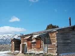 Location within the state of Nevada
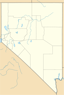
 Cherry Creek
Coordinates: 39°54′14″N 114°53′24″W / 39.90389°N 114.89°WCoordinates: 39°54′14″N 114°53′24″W / 39.90389°N 114.89°W Country United States State Nevada County White Pine Time zone Pacific (PST) (UTC-8) - Summer (DST) PDT (UTC-7) ZIP codes FIPS code GNIS feature ID Cherry Creek is a historic community located in northern White Pine County, in northeastern Nevada in the western United States. It is a census county division (CCD), with a population at the 2010 census of 72.
It is located in the northern part of the long Steptoe Valley, north of the modern communities of McGill and Ely. Immediately to the west is the Cherry Creek Range, while to the east is U.S. Route 93 and the Schell Creek Range. Just to the south, in Egan Canyon, the Pony Express and subsequent stage lines made their way through the mountains of central Nevada in the 1860s.
In the early 1860s, gold and silver were discovered nearby. The town was built in 1873, starting a cycle of boom and bust. It may have had a population of up to 6000 in the late 1870s, many of whom left when the original mines played out in the mid-1880s. The discovery of additional deposits in the early 1900s and in the 1930s briefly revived the economy. Today there is an estimated population of just 20 residents and, of course, a working saloon. Many historic structures, including a museum, an early one-room schoolhouse, and the Cherry Creek Barrel Saloon, still stand among more modern buildings. As of July 2010 the Barrel Saloon closed.
External links
Municipalities and communities of White Pine County, Nevada County seat: Ely City 
CDP Unincorporated
communitiesCherry Creek | Crosstimbers | East Ely | Lages Station | Majors Place | Riepetown | Schellbourne | Strawberry
Indian reservation Ghost towns Categories:- Unincorporated communities in Nevada
- Populated places in White Pine County, Nevada
- Populated places established in 1873


Wikimedia Foundation. 2010.