- Orlingbury
-
Coordinates: 52°20′22″N 0°44′02″W / 52.3394°N 0.7339°W
Orlingbury 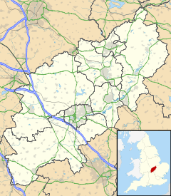
 Orlingbury
Orlingbury shown within NorthamptonshirePopulation 395 OS grid reference SP8672 District Wellingborough Shire county Northamptonshire Region East Midlands Country England Sovereign state United Kingdom Post town Kettering Postcode district NN14 Dialling code 01933 Police Northamptonshire Fire Northamptonshire Ambulance East Midlands EU Parliament East Midlands UK Parliament Wellingborough List of places: UK • England • Northamptonshire Orlingbury is a village and civil parish in the English county of Northamptonshire. It is between the towns of Kettering and Wellingborough. Administratively it forms part of the borough of Wellingborough. At the time of the 2001 census, the parish's population was 395 people.[1]
On the ouskirts of Orlingbury is a cricket ground, home of Isham Cricket Club[2] who play in Division 1 of The Northamptonshire County League. Past players have included Stephen Fleming (New Zealand national cricket team Captain), Johann Myburgh (SA Titans) and John Hughes (Northamptonshire County Cricket Club). Orlingbury's pub is the 'Queen's Arms', situated on the main road.
See also
- Deserted village of Wythmail
References
- ^ Office for National Statistics: Orlingbury CP: Parish headcounts. Retrieved 15 November 2009
- ^ Isham Cricket Club website
External links
- Brief details
- Parish council contact details
- Photograph
- Map sources for Orlingbury
The Borough Council of Wellingborough, Northamptonshire Settlements Bozeat · Earls Barton · Easton Maudit · Ecton · Finedon · Great Doddington · Great Harrowden · Grendon ·
Hardwick · Irchester · Isham · Little Harrowden · Little Irchester · Mears Ashby · Orlingbury · Strixton ·
Sywell · Wilby · Wellingborough (Redhill Grange) · Wollaston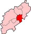
Places of interest Chester House Farm · Harrowden Hall · Irchester Country Park · The Castle Theatre · Wellingborough MuseumConstituencies Sport Transport A45 road · A509 road · East Midlands Trains · First Northampton · Stagecoach in Northants · Sywell Aerodrome · Wellingborough railway stationEducation Friars School · Sir Christopher Hatton School · Tresham College of Further and Higher Education ·
Weavers School · Wellingborough School · Wrenn School · Wollaston SchoolEast Midlands · England Portal · WikiProject Northamptonshire · United Kingdom Portal Categories:- Villages in Northamptonshire
- Northamptonshire geography stubs


Wikimedia Foundation. 2010.