- 1999–00 South-West Indian Ocean cyclone season
-
1999–00 South-West Indian Ocean cyclone season 
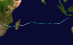
Season summary mapFirst storm formed: December 23, 1999 Last storm dissipated: April 23, 2000 Strongest storm: Hudah – 905 hPa (mbar), 220 km/h (140 mph) (10-minute sustained) Total disturbances: 14 Total storms: 9 Tropical cyclones: 4 Intense cyclones: 3 Total fatalities: At least 1000 Total damage: Unknown South-West Indian Ocean cyclone seasons
1997–98, 1998–99, 1999–00, 2000–01, 2001–02Related articles: The 1999-00 South-West Indian Ocean tropical cyclone season was an event in the annual cycle of tropical cyclone formation and ran from November 1, 1999 to April 30, 2000 in the South-West Indian Ocean, with the exception of Mauritius and the Seychelles, for which it ran until May 15.
Cyclone Leon-Eline was one of the most notable storms of the season, existing for 22 days while transversing the whole southern Indian Ocean, and causing severe flooding in South Africa, Mozambique and Madagascar.
Storms
Severe Tropical Storm Astride
Severe tropical storm (MFR) Category 1 tropical cyclone (SSHS) 

Duration December 23 – January 3 Intensity 95 km/h (60 mph) (10-min), 985 mbar (hPa) On December 24, 1999, a low formed about 240 nmi (440 km) southeast of Diego Garcia and moved westward. The disturbance was upgraded to tropical depression status on December 25, 1800 hours (UTC), and upgraded to moderate tropical storm intensity on December 26 and named Astride. It moved to the west south-west and reached severe tropical storm intensity on December 27 0000 (UTC) with 10-min MSW near 50 knots (93 km/h), located 190 nmi (350 km) north-east of St. Brandon. Astride slowed its forward motion while intensifying (JTWC estimated 1-min winds of 65 kt). Astride began to slowly weaken from early December 28. On December 30 Astride intensified and was upgraded again to severe tropical storm intensity while moving to the west north-west, but downgraded again to moderate storm intensity at 1800 (UTC) on the same day. Astride made landfall between 1800 (UTC) on December 31 and 0000 (UTC) on January 1, 2000 30 nmi (56 km) northeast of Vohemar, Madagascar. It moved into the Mozambique Channel and intensified briefly, but weakened again, and made another landfall near Mogincual, Mozambique at 0000 (UTC) on January 3.[1]
Tropical Cyclone Babiola
Tropical cyclone (MFR) Category 2 tropical cyclone (SSHS) 

Duration January 3 – January 12 Intensity 155 km/h (100 mph) (10-min), 950 mbar (hPa) An area of convection formed 130 nmi (240 km) south south-east of Diego Garcia. It moved eastward, then moved southwest and strengthened. MFR upgraded to a depression on the 6th at 0000 (UTC) and upgraded to Moderate Tropical Storm Babiola at 0600 (UTC) on the same day. It continued to move south-west, then accelerated more to the west southwest while reaching cyclone strength on January 7 at 1200 (UTC), centred 575 nmi (1,065 km) south of Diego Garcia. Babiola reached peak intensity late on January 9 and a ragged eye appeared 20 nmi (37 km) in diameter. JTWC estimated 1-min winds of 90 knots (170 km/h), and MFR estimated 10-min winds of 80 knots (150 km/h) and a minimum central pressure of 954 mbar. Babiola moved southward on the 10th and began to weaken and became elongated. It continued to weaken on the 11th while moving to the south south-east and becoming extra-tropical. JTWC issued its last warning on January 12 at 0600 (UTC). No damage was reported.[2]
Tropical Disturbance 03
Tropical disturbance (MFR) 
Duration January 12 – January 24 Intensity 45 km/h (30 mph) (10-min), 998 mbar (hPa) This disturbance persisted in the Mozambique Channel.
Intense Tropical Cyclone Connie
Intense tropical cyclone (MFR) Category 4 tropical cyclone (SSHS) 

Duration January 25 – February 1 Intensity 185 km/h (115 mph) (10-min), 930 mbar (hPa) An area of convection appeared on January 24. It quickly strengthened to tropical storm status on the 25th at 1800 (UTC) and was named Connie. The storm moved northward a bit, but remained quasi-stationary about 380 nmi (700 km) north north-west of Mauritius. MFR upgraded Connie to cyclone status with 80 knots (150 km/h) winds. Connie strengthened rapidly and on January 27, a well-defined eye 15 nmi (28 km) wide was located 235 nmi (435 km) northwest of Mauritius. JTWC estimated 1-min winds of 115 knots (213 km/h), and MFR estimated 10-min winds of 100 knots (190 km/h) and a minimum central pressure of 928 mbar on January 28. Connie moved to the south west which carried it 100 nmi (190 km) west of Réunion and began weakening. Connie recurved to the south south-east on the 30th. On the 31st Connie held on its intensity of 55 knots (102 km/h), then rapidly weakened on February 1 and was taking on extratropical characteristics while moving south-eastward.
Connie affected the islands of Mauritius and Réunion, dumping rainfall up to 200 mm. In Mauritius, this provided some relief for the drought-stricken island, but was still not enough. Connie was responsible for two deaths in Reunion. One hundred homes were destroyed with at least 600 people homeless.[2]
Moderate Tropical Storm Damienne
Moderate tropical storm (MFR) Tropical storm (SSHS) 

Duration January 30 – February 4 Intensity 65 km/h (40 mph) (10-min), 994 mbar (hPa) On January 31, 2000 a low formed in the central south Indian Ocean about 300 nmi (560 km) south-east of Diego Garcia. On February 1 the storm reached tropical storm strength and was named Damienne. It moved southward with 1-min winds estimated at 45 knots (83 km/h) by JTWC, and 10-min winds of 40 knots (74 km/h) estimated by MFR. Although forecast to strengthen, the storm did not last long and it quickly dissipated on February 2 while moving south-westward.[3]
Intense Tropical Cyclone Leon-Eline
Intense tropical cyclone (MFR) Category 4 tropical cyclone (SSHS) 
Duration February 7 – February 22 Intensity 185 km/h (115 mph) (10-min), 930 mbar (hPa) Main article: Cyclone Leon-ElineCyclone Leon, which had developed in Perth's warning area, crossed 90°E on February 8 and was renamed Eline by the sub-regional tropical cyclone advisory centre in Mauritius. Leon-Eline moved through the southern Indian Ocean towards Africa and drenched South Africa, Mozambique and Madagascar with heavy rains and gusty winds, causing severe damage. It dissipated over the African mainland on February 23, after causing over 1,000 fatalaties.
Severe Tropical Storm Felicia
Severe tropical storm (MFR) Category 1 tropical cyclone (SSHS) 

Duration February 18 – February 24 Intensity 110 km/h (70 mph) (10-min), 975 mbar (hPa) A low formed on February 17 near 13˚S, 81˚E. It was classified a tropical storm br MFR on the 20th at 0000 (UTC) while located 500 nmi (930 km) south southeast of Diego Garcia and was named Felicia. It moved west southwestward which later became south westward. It was temporarily downgraded to a depression at 1800 (UTC), but upgraded again 12 hours later. On February 23, it reached its peak intensity. JTWC estimated 1-min winds of 50 knots (93 km/h), but MFR estimated 10-min winds of 60 knots (110 km/h). Felicia continued to move to the south southwest, but it weakened rapidly thereafter. MFR issued its final warning on February 24 at 0600 (UTC) as it transitioned into an extratropical low, located 665 nm south south-east of Rodrigues Island.[3]
Severe Tropical Storm Gloria
Severe tropical storm (MFR) Tropical storm (SSHS) 

Duration February 27 – March 8 Intensity 95 km/h (60 mph) (10-min), 985 mbar (hPa) An area of convection east of northern Madagascar formed on February 27. MFR started issuing bulletins on February 28 at 0600 (UTC) when the system was located 600 nmi (1,100 km) east of northern Madagascar. It was upgraded to a depression on February 29 at 0000 (UTC) while moving westward, and started moving more northerly. The depression was upgraded to Tropical Storm Gloria on March 1 at 0600 (UTC) and turned to the south-west at 9 knots (17 km/h). Gloria's centre made landfall near Antsirabe, Madagascar around 1800 (UTC). JTWC's estimated 1-min average sustained winds was 65 knots (120 km/h), based on infrared imagery showing a 15 nmi (28 km) wide closed eye along the coast. MFR's estimated 10-min average wind speed was somewhat lower at 45 knots (83 km/h). On March 2 at 0600 (UTC), MFR issued its last warning. JTWC continued to monitor the system for the next three days as it drifted south-westward over Madagascar. JTWC was consistently forecasting re-intensification over the Mozambique Channel, but on March 5, the system weakened, and the final warning was written while over the Channel.
Tropical Storm Gloria brought heavy rainfall to northern Madagascar. Mananjary recorded 427 mm in a 48 hour period ending on March 5. The death toll was about 150. Andapa was the most affected city, with 40 people dead and 33 unaccounted for. Over 100 homes were destroyed in the city. The population was affected by an outbreak of cholera. The road linking this region to the capital was blocked, and this was expected to have a significant negative impact on the region's economy.[3]
Tropical Depression 09
Tropical depression (MFR) Tropical storm (SSHS) 
Duration February 29 – March 11 Intensity 55 km/h (35 mph) (10-min), 998 mbar (hPa) This system was classified as Tropical Cyclone 17S by the Joint Typhoon Warning Center.
Tropical Disturbance 10
Tropical disturbance (MFR) Duration March 2 – March 3 Intensity 45 km/h (30 mph) (10-min), 1002 mbar (hPa) Tropical Disturbance 11
The remnants of Severe Tropical Cyclone Norman were anticipated to move across 90°E, so Météo-France issued a few bulletins on the system. They assigned it the number 11.[4]
Very Intense Tropical Cyclone Hudah
Very intense tropical cyclone (MFR) Category 4 tropical cyclone (SSHS) 

Duration March 24 – April 8 Intensity 220 km/h (140 mph) (10-min), 905 mbar (hPa) Cyclone Hudah was an intense and long-lived tropical cyclone that rampaged through the South Indian Ocean from March 24 to April 9, causing massive damage in Madagascar and Mozambique. Striking the area barely a month after Cyclone Leon-Eline roared through the two countries, the combination severely damaged the fragile economies of Mozambique and Madagascar.
Subtropical Depression 13
Subtropical depression (SSHS) Duration April 7 – April 15 Intensity 95 km/h (60 mph) (10-min), 992 mbar (hPa) This storm existed in the Mozambique Channel.
Moderate Tropical Storm Innocente
Moderate tropical storm (MFR) Tropical storm (SSHS) 

Duration April 11 – April 23 Intensity 70 km/h (45 mph) (10-min), 993 mbar (hPa) An area of disturbance was located on April 9 between Cocos (Keeling) Islands and Christmas Island. It moved west for a few days. MFR began issuing bulletins, as the low crossed the 90 degree East longitude line on April 12 at 1800 (UTC). It still moved westward; on the 14th, it weakened, and the issuing of bulletins were temporarily stopped, however, they were re-instigated on the 15th, as it regenerated. JTWC began issuing warnings at 1800 (UTC) on the same day, while located 640 nmi (1,190 km) southeast of Diego Garcia. At 1200 (UTC) on the April 16, MFR upgraded to Tropical Storm Innocente, but was downgraded back to a depression six hours later. On April 17 at 1800 (UTC), MFR upgraded to Tropical Storm Innocente again. It was still moving in a west south-westerly course and began to weaken. At 0000 (UTC) on the April 19, MFR downgraded it to a depression, and wrote their final warning six hours later, while located 400 nm east northeast of Rodrigues Island. The remnant low remained for several days, but failed to show any redevelopment.[5]
Storm names
A tropical disturbance is named when it reaches moderate tropical storm strength. If a tropical disturbance reaches moderate tropical storm status west of 55°E, then the Sub-regional Tropical Cyclone Advisory Centre in Madagascar assigns the appropriate name to the storm. If a tropical disturbance reaches moderate tropical storm status between 55°E and 90°E, then the Sub-regional Tropical Cyclone Advisory Centre in Mauritius assigns the appropriate name to the storm. A new annual list is used every year so no names are retired.[6]
- Astride
- Babiola
- Connie
- Damienne
- Eline
- Felicia
- Gloria
- Hudah
- Innocente
- Jonna (unused)
- Kenetha (unused)
- Lisanne (unused)
- Maizy (unused)
- Nella (unused)
- Ortensia (unused)
- Priscilla (unused)
- Rebecca (unused)
- Sophia (unused)
- Terrence (unused)
- Victorine (unused)
- Wilna (unused)
- Yanselma (unused)
See also
- List of Southern Hemisphere tropical cyclone seasons
- Atlantic hurricane seasons: 1999, 2000
- Pacific hurricane seasons: 1999, 2000
- Pacific typhoon seasons: 1999, 2000
- North Indian Ocean cyclone seasons: 1999, 2000
References
- ^ Gary Padgett. "MONTHLY GLOBAL TROPICAL CYCLONE SUMMARY - DECEMBER, 1999". http://www.australiansevereweather.com/cyclones/2000/summ9912.htm. Retrieved August 7, 2006.
- ^ a b Gary Padgett. "MONTHLY GLOBAL TROPICAL CYCLONE SUMMARY - JANUARY, 2000". http://www.australiansevereweather.com/cyclones/2000/summ0001.htm. Retrieved August 7, 2006.
- ^ a b c Gary Padgett. "MONTHLY GLOBAL TROPICAL CYCLONE SUMMARY - FEBRUARY, 2000". Archived from the original on March 16, 2006. http://web.archive.org/web/20060316081237/http://www.australiansevereweather.com/cyclones/2000/summ0002.txt. Retrieved August 7, 2006.
- ^ Gary Padgett. "MONTHLY GLOBAL TROPICAL CYCLONE SUMMARY - MARCH, 2000". Archived from the original on 2009-05-13. http://www.australiasevereweather.com/cyclones/2000/summ0003.htm. Retrieved April 7, 2009.
- ^ Gary Padgett. "MONTHLY GLOBAL TROPICAL CYCLONE SUMMARY - APRIL, 2000". http://www.australiansevereweather.com/cyclones/2000/summ0004.htm. Retrieved August 7, 2006.
- ^ "Tropical Cyclone Operational Plan for the South Pacific and South-East Indian Ocean". World Meteorological Organization. 2003. http://ftp.wmo.int/pages/prog/www/TCP_vO/OperationPlans/TCP12-English2003.pdf. Retrieved 2008-08-15.
External links
- Joint Typhoon Warning Center (JTWC).
- Météo France (RSMC La Réunion).
- World Meteorological Organization
- Annual Summary of Global Tropical Cyclone Seasons 2000
- RA I Tropical Cyclone Committee Final Report
- Joint Typhoon Warning Center 2000 ATCR
- 1999-00 Best Track Data from Météo France
- July 1999 to June 2000 Tropical Cyclone Summaries and Operational Track Data
- Gary Padgett's Southern Hemisphere 1999-2000 Tropical Cyclone Season Review
Categories:- 1999–2000 Southern Hemisphere tropical cyclone season
- 1999–00 South-West Indian Ocean cyclone season


Wikimedia Foundation. 2010.