- Coldwaltham
-
Coordinates: 50°56′21″N 0°32′38″W / 50.93911°N 0.54389°W
Coldwaltham 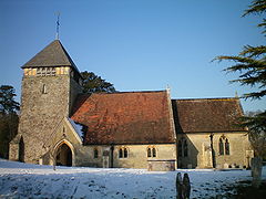
St. Giles Church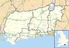
 Coldwaltham
Coldwaltham shown within West SussexArea 8.93 km2 (3.45 sq mi) [1] Population 845 [1] 2001 Census - Density 95 /km2 (250 /sq mi) OS grid reference TQ024165 - London 43 miles (69 km) NNE Parish Coldwaltham District Horsham Shire county West Sussex Region South East Country England Sovereign state United Kingdom Post town PULBOROUGH Postcode district RH20 Dialling code 01798 Police Sussex Fire West Sussex Ambulance South East Coast EU Parliament South East England UK Parliament Arundel and South Downs List of places: UK • England • West Sussex Coldwaltham is a village and civil parish in the Horsham District of West Sussex, England. It is divided in two by the A29 road and lies 2.4 miles (3.9 km) southwest of Pulborough which has both a railway station on the Arun Valley Line and a bus connection to Worthing. It is around a 30 minute drive from Gatwick Airport.
The 13th century Anglican parish church is dedicated to Saint Giles; a rare 11th century gravestone and a simple Saxon font are present on the site. A yew tree near the north west corner is among the oldest in England, believed to be over 3000 years old.[2] There is one pub, the Labouring Man. Sandam Hall is used for village events.
The Church of England primary school shares a headteacher with Amberley School.
References
- ^ a b "2001 Census: West Sussex – Population by Parish". West Sussex County Council. http://www.westsussex.gov.uk/communityandliving/census2001/pop_parish_summary.pdf. Retrieved 12 April 2009.
- ^ A Church near You
External links
Categories:- West Sussex geography stubs
- Horsham
- Villages in West Sussex


Wikimedia Foundation. 2010.