- Maryland Route 322
-
Maryland Route 322
Easton Parkway 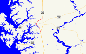
Map of central Talbot County, Maryland with MD 322 highlighted in redRoute information Maintained by MDSHA Length: 5.12 mi[1] (8.24 km) Major junctions South end:  US 50 south of Easton
 MD 565 in Easton
 MD 333 in Easton
 MD 334 in Easton
 MD 33 in Easton
North end: US 50 north of EastonLocation Counties: Talbot Highway system Maryland highway system
Interstate • US • State • Minor • Former • Turnpikes←  MD 320
MD 324  →
→Maryland Route 322 (MD 322) is a state highway in the U.S. state of Maryland. Known as Easton Parkway, the highway runs 5.12 miles (8.24 km) on the west side of Easton between two junctions with U.S. Route 50 (US 50). MD 322 serves as a bypass of downtown Easton for traffic between US 50 and highways to western Talbot County, including MD 33 toward Saint Michaels and MD 333 toward Oxford. Easton Parkway was constructed in the mid to late 1960s. The state highway was originally designated as part of MD 33; MD 322 became the sole designation on the bypass in 1978.
Contents
Route description
 Northbound MD 322 at its intersection with MD 33
MD 322 begins at a directional intersection with US 50 (Ocean Gateway) south of Easton; there is no direct access from southbound MD 322 to westbound US 50. MD 322 heads north as a four-lane divided highway to MD 565 (Washington Street). Beyond this intersection, the state highway reduces to two lanes, curves to the northwest, and crosses Paper Mill Pond. MD 332 parallels the pond through the highway's intersection with MD 333, which heads southwest as Oxford Road and northeast as Peach Blossom Road. After the pond turns west, the state highway intersects Port Street, which heads east toward downtown Easton as MD 334 and west as a county highway into the Easton Point industrial area.[1][2]
MD 322 temporarily expands to a four-lane undivided highway at its intersection with MD 33, which heads east as Bay Street toward downtown Easton and west as St. Michaels Road. The MD 322–MD 33 intersection lies on a crossing of Tanyard Creek just east of its confluence with an unnamed creek to form the North Fork of the Tred Avon River. MD 322 continues northeast past several shopping centers and industrial parks between MD 33 and Glebe Road. Near its northern terminus, the state highway meets the northern end of Washington Street and Airpark Drive, which immediately has an intersection with MD 662 (Centreville Road) before entering an industrial park adjacent to Easton Airport. MD 322 reaches its northern terminus at a directional intersection with US 50.[1][2]
History
Easton Parkway was constructed as a way for traffic from Oxford and Saint Michaels to access points north and south via US 50 without having to travel through downtown Easton.[3] The first section of the state highway was completed in 1965 from the present intersection with MD 33 north to US 50. MD 33 was removed from Bay Street and Washington Street north of downtown Easton and placed on the first section of Easton Parkway.[4][5] The highway was extended south to MD 333 in 1966.[6] The remainder of the highway south to US 50 was completed in 1970.[7] The MD 322 designation was originally applied to the southern part of the parkway as well as Bay Street.[8] MD 33 and MD 322 were reassigned to their present lengths of highway in 1978.[9]
Junction list
The entire route is in Easton in Talbot County.
Mile
[1]Destinations Notes 0.00 US 50 (Ocean Gateway) – CambridgeSouthern terminus; no access from southbound MD 322 to westbound US 50 0.53 MD 565 north (Washington Street)Officially MD 565A 1.59 MD 333 (Peach Blossom Road/Oxford Road) – Oxford2.41 MD 334 east (Port Street) / Port Street west2.98 MD 33 (Bay Street/St. Michaels Road) – St. Michaels, Tilghman Island4.64 Airpark Drive west to  MD 662 north (Centreville Road) / Washington Street south
Airpark Drive is officially MD 332B 5.12 US 50 (Ocean Gateway) – Bay BridgeNorthern terminus 1.000 mi = 1.609 km; 1.000 km = 0.621 mi Auxiliary routes
- MD 322A is the designation for the unnamed 0.07-mile (0.11 km) ramp from eastbound US 50 to northbound MD 322 south of Easton.[1][10]
- MD 322B is the designation for the 0.03-mile (0.048 km) section of Airpark Drive between MD 322 and MD 662 north of Easton.[1][11]
References
- ^ a b c d e f "Highway Location Reference: Talbot County" (PDF). Maryland State Highway Administration. 2009. http://www.marylandroads.com/Location/2009_TALBOT.pdf. Retrieved 2010-09-12.
- ^ a b Google, Inc. Google Maps – Maryland Route 322 (Map). Cartography by Google, Inc. http://maps.google.com/maps?f=d&source=s_d&saddr=Easton+Blvd%2FEaston+Pkwy&daddr=Easton+Pkwy+to:Unknown+road&hl=en&geocode=FfodTwId-EV3-w%3BFRqpTwIdUAF3-w%3BFdQKUAIdZWp3-w&mra=ls&sll=38.799233,-76.058521&sspn=0.007676,0.01929&ie=UTF8&t=h&z=13. Retrieved 2010-09-12.
- ^ "Town of Easton 2010 Comprehensive Plan - Transportation" (PDF). Town of Easton, Maryland. http://www.town-eastonmd.com/Planning/2010_Comp_Plan/TRANSPORTATION.pdf. Retrieved 2010-09-12.
- ^ Maryland State Roads Commission. Maryland: Official Highway Map (Map) (1964 ed.).
- ^ Maryland State Roads Commission. Maryland: Official Highway Map (Map) (1965 ed.).
- ^ Maryland State Roads Commission. Maryland: Official Highway Map (Map) (1966 ed.).
- ^ Maryland State Roads Commission. Maryland: Official Highway Map (Map) (1970 ed.).
- ^ United States Geological Survey (1974-07-01). Easton, Maryland, United States (Map). Topo Map. http://msrmaps.com/image.aspx?T=2&S=12&Z=18&X=507&Y=5365&W=3&qs=. Retrieved 2010-09-12.
- ^ Maryland State Highway Administration. Maryland: Official Highway Map (Map) (1978 ed.).
- ^ Google, Inc. Google Maps – Maryland Route 322A (Map). Cartography by Google, Inc. http://maps.google.com/maps?f=d&source=s_d&saddr=Unknown+road&daddr=Unknown+road&hl=en&geocode=FWUiTwIdyUd3-w%3BFU4iTwIdAkR3-w&mra=ls&sll=38.740737,-76.068655&sspn=0.001887,0.004823&ie=UTF8&ll=38.740235,-76.069282&spn=0.003774,0.009645&t=h&z=17. Retrieved 2011-04-07.
- ^ Google, Inc. Google Maps – Maryland Route 322B (Map). Cartography by Google, Inc. http://maps.google.com/maps?f=d&source=s_d&saddr=N+Washington+St&daddr=Centreville+Rd&hl=en&geocode=Fer1TwId7FV3-w%3BFeT2TwIdSFR3-w&mra=ls&sll=38.794845,-76.06549&sspn=0.000471,0.001206&ie=UTF8&ll=38.794889,-76.064669&spn=0.001886,0.004823&t=h&z=18. Retrieved 2011-04-07.
External links
Roads in Talbot County, Maryland State highways 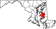
U.S. Highways Categories:- State highways in Maryland
- Roads in Talbot County, Maryland


Wikimedia Foundation. 2010.