- Lhatse
-
Lhatse Lhatse Chode Monastery
 Lhatse
Coordinates: 29°8′11″N 87°38′6″E / 29.13639°N 87.635°E Country China Province Tibet Autonomous Region Prefecture Nyingchi Prefecture County Time zone CST (UTC+8) Part of a series on Tibetan Buddhism

History Timeline · Related-topics Schools Nyingma · Kagyu · Sakya · Gelug · Bön · Jonang Key concepts Three marks of existence · Skandha · Cosmology · Saṃsāra · Rebirth · Bodhisattva · Dharma · Dependent origination · Karma Major figures Gautama Buddha · Padmasambhava · Je Tsongkhapa · Dalai Lama · Panchen Lama · Lama · Karmapa Lama · Rinpoche · Geshe · Terton · Tulku Buddhahood · Avalokiteśvara · Four stages of enlightenment · Tantric yoga · Paramitas · Meditation · Laity Changzhug · Drepung · Dzogchen · Ganden · Jokhang · Kumbum · Labrang · Mindroling · Namgyal · Narthang · Nechung · Pabonka · Palcho · Ralung · Ramoche · Sakya · Sanga · Sera · Shalu · Tashilhunpo · Tsurphu · Yerpa Chotrul Duchen · Dajyur · Losar · Monlam · Sho Dun Texts Kangyur · Tengyur · Tibetan canon · Mahayana sutras · Nyingma Gyubum Sand mandala · Thangka · Ashtamangala · Tree of physiology Outline · Comparative studies · Culture · List of topics · Portal

The new town of Lhatse (Lha rtse) or Lhatse Xian (Pinyin: Lhazê), is also known as Chusar (Quxar), is a small town of a few thousand people in Tibet, in the valley of the Yarlung Zangbo River (aka Brahmaputra) 151 km southwest of Shigatse and just west of the mountain pass leading to it. Lhatse is 4,050 m. (13,287 ft) above sea-level.[1]
The modern town is 10 km south of the old village of Lhatse and the small Gelugpa monastery of Lhatse Chode. Above the monastery are the ruins of the old fort or Lhatse Dzong (Lha rtse rdong) or Drampa Lhatse (Gram pa Lha rtse) which are on a rock 150 m (492 ft) high at the opening of the Yarlung Tsangpo Canyon.[2][3]
At the western end of the town is another small monastery, the Changmoche Monastery. 10 km east of Lhatse are the Xiqian Hot Springs widely renowned for their healing properties.[4]
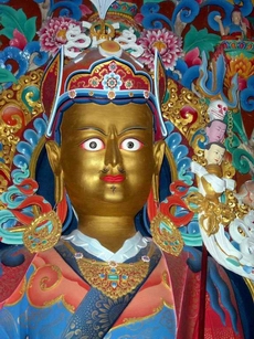
Further east are the ruins of the Drampa Gyang (Gram pa rgyangs) Lhakhang, one of King Songsten Gampo's main geomantic temples built in the 7th century. It was thought to pin down the troublesome left hip of the demoness whose body lay under all the high plateau with her heart located under the Jokhang temple in Lhasa.[5] It once housed a famous image of Vairocana Buddha.[6]
Near this spot in the 14th century the famous terton or treasure finder, Sangpo Drakpa, discovered the popular Nyingma text by Guru Rinpoche called the Leu Dunma, which is a collection of prayers and devotions. To the north are the massive ruins of the Gyang Bumoche or Gyang Bumpoche, once 20 m (66 ft) high,[7] which was built in the style of the Gyantse Kumbum by Sakyapa Sonam Tashi (1352-1417) and the famous polymath and bridge builder, Thangtong Gyalpo or Tangton Gyelpo (1385-1464), and decorated in the Lato style of painting.[8] This Jonang kumbum was also called Tongdrol Chempo ('The Great Chorten that Gives Liberation by Setting Eyes upon It').[9]
East of the ruins of the kumbum is the reconstructed Phuntsoling Monastery which was once attached to it. The main monastery and kumbum were restored and expanded by the renowned historian Taranatha (1575-1634) of the Jonangpa sect of the Kagyupa. Under the Great Fifth Dalai Lama (1617 – 1682), the Jonang school was suppressed and it was converted to the Gelugpa school after Taranatha's death.[10]
Further east is a beautiful little valley where there was previously a Nyingma gompa and hermitages, above which is the large Guru Rinpoche cave of Gyang Lompo Lung which contains a shrine. The whole valley was, however, deserted in 1985.[11]
Because the roads to Mount Everest and to Mount Kailash divide just west of Lhatse, the town is a popular lunch stop for tour groups heading to those locations. Buddhist festivals are sometimes held at the monastery, drawing inhabitants from the surrounding region. There are several hotels and restaurants in the town.
Footnotes
- ^ Mayhew and Kohn (2005), p. 185.
- ^ Dowman (1988), pp. 277-278.
- ^ Dorje (1999), p. 289.
- ^ Mayhew and Kohn (2005), pp. 185-187.
- ^ * Mayhew and Kohn (2005), pp. 96, 187.
- ^ Dorje (1999), p. 288.
- ^ * Mayhew and Kohn (2005), p. 187.
- ^ Dorje (1999), p. 289.
- ^ Dowman (1988), p. 279.
- ^ Dowman (1988), p. 279.
- ^ Dowman (1988), pp. 278-279.
References
- Dorje, Gyume. (1999). Footprint Tibet Handbook with Bhutan. Footprint Handbooks, Bath, England. ISBN 0 8442-2190-2.
- Dowman, Keith. 1988. The Power-Places of Central Tibet: The Pilgrim's Guide. Routledge & Kegan Paul. London. ISBN 0-7102-1370-0 (ppk).
- Mayhew and Kohn (2005). Tibet. Bradley Mayhew and Michael Kohn. 6th edition. Lonely Planet. 1st Edition 1986.
Coordinates: 29°8′11″N 87°38′6″E / 29.13639°N 87.635°E
Xigazê Prefecture, Tibet County-level divisions 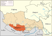
Settlements Landmarks Changmoche Monastery · Lhatse · Chokorgyel Monastery · Daklha Gampo · Donggar Monastery · Dorje Pakmo · Drongtse Monastery · Garju Monastery · Manmogang Monastery · Menri Monastery · Milarepa's Cave · Narthang Monastery · Ngor · Palcho Monastery · Ralung Monastery · Samding Monastery · Sakya Monastery · Ṣalu Monastery · Samding Monastery · Shelkar · Tashilhunpo · Tsi Nesar ·Buddhist monasteries in Tibet Lhasa Prefecture Ani Tsankhung Nunnery · Drepung Monastery · Drigung Monastery · Ganden Monastery · Jokhang · Kundeling Monastery · Muru Nyingba Monastery · Namgyal Monastery · Nechung · Nyethang Drolma Lhakhang Temple · Ramoche Temple · Reting Monastery · Sanga Monastery · Taklung Yarthang Monastery · Tradruk Temple · Tsomon Ling · Tsurphu Monastery · Yangpachen Monastery · Yerpa · Zhuowaqudeng Monastery
Sera Monastery: · Chupzang Nunnery · Drakri Hermitage · Garu Nunnery · Jokpo Hermitage · Keutsang Hermitage · Keutsang East Hermitage · Keutsang West Hermitage · Khardo Hermitage · Negodong Nunnery · Nenang Nunnery · Pabongkha Hermitage · Panglung Hermitage · Purbuchok Hermitage · Rakhadrak Hermitage · Sera Chöding Hermitage · Sera Gönpasar Hermitage · Sera Utsé Hermitage · Takten Hermitage · Trashi Chöling HermitageShannan Prefecture Shigatse Prefecture Changmoche Monastery · Lhatse · Chokorgyel Monastery · Daklha Gampo · Dorje Pakmo · Drongtse Monastery · Donggar Monastery · Garju Monastery · Manmogang Monastery · Menri Monastery · Milarepa's Cave · Narthang Monastery · Ngor · Palcho Monastery · Ralung Monastery · Samding Monastery · Sakya Monastery · Ṣalu Monastery · Shelkar · Tashilhunpo · Tsi Nesar · Tsechen Monastery and DzongNgari Prefecture Chamdo Prefecture
and former KhamGalden Jampaling Monastery · Karma Gon Monastery · Benchen Monastery · Dorje Drak · Dzogchen Monastery · Dzongshar Monastery · Kandze Monastery · Katok Monastery · Nanwu Si Monastery · Palyul · Riwoche Monastery · Shechen Monastery · Surmang · Tongkor ·Nyingchi Prefecture Categories:- Buddhist monasteries in Tibet
- History of Tibet
- Populated places in Tibet


Wikimedia Foundation. 2010.