- Makronisos
-
Makronisos
Μακρόνησος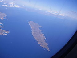
Aerial picture of MakronisosGeography 
Coordinates: 37°41′N 24°08′E / 37.683°N 24.133°E Island chain: None Area: 20 km² (8 sq.mi.) Government  Greece
Periphery: South Aegean Prefecture: Cyclades Capital: Uninhabited Statistics Population: 0 (as of 2001) Density: 0 /km² (0 /sq.mi.) Postal code: 840 02 Area code: 22880 Makronisos (Greek: Μακρόνησος, lit. Long Island) is an island in the Aegean sea, in Greece and is located close to the coast of Attica, facing the port of Lavrio. It has an elongated shape (3km north to south, ca. 500 m east to west) and its terrain is arid and rocky. In ancient times the island was called Helena. It is part of the prefecture of the Cyclades but it is not part of that island chain. Administratively, it is part of the municipality of Kea. The island is currently uninhabited. However, from the time of the Greek Civil War up until the restoration of democracy following the collapse of the Regime of the Colonels, it was used as a place of imprisonment for Greek communists, hosting hundreds of prisoners. Because of its history, it is considered as a monument of the civil war era; therefore the island itself and the original structures on it are protected from alterations. The straits between Makronisos and neighbouring Kea are the site of the sinking, in 1916, of HMHS Britannic, sister ship of the RMS Titanic.
Contents
Geography
- Location:
- Longitude: 24.13 (24°7'8') E
- Latitude: 37.694 (37°41'30') N
- Postal code: 840 02
- Elevation:
- lowest: sea level
- highest: 281 m
- Area: about 20 km²
- Dialing code: +30-22880 (030-22880)-34
Further reading
- Hamilakis, Yannis, "The Other 'Parthenon': Antiquity and National Memory at Makronisos", Journal of Modern Greek Studies 20:2 (October 2002), pp. 307-338.
References
External links
Articles on the Aegean Sea GeneralCountries Other Cyclades Amorgos · Anafi · Andros · Antimilos · Antiparos · Delos · Despotiko · Donoussa · Folegandros · Gyaros · Ios · Irakleia · Kardiotissa · Kea · Keros · Kimolos · Koufonisia · Kythnos · Milos · Mykonos · Nata · Naxos · Paros · Polyaigos · Rineia · Santorini · Schoinoussa · Serifopoula · Serifos · Sifnos · Sikinos · Syros · Therasia · Tinos · VousDodecanese Agathonisi · Arkoi · Armathia · Alimia · Astakida · Astypalaia · Çatalada · Chalki · Chamili · Farmakonisi · Gaidaros · Gyali · Imia/Kardak · Kalolimnos · Kalymnos · Kandelioussa · Kara Ada · Karpathos · Kasos · Kinaros · Kos · Küçük Tavşan Adası · Leros · Lipsi · Lebynthos · Nimos · Nisyros · Patmos · Pacheia · Platy · Pserimos · Rhodes · Saria · Salih Ada · Symi · Syrna · Telendos · Tilos · ZaforaNorth Aegean Agios Eustratius · Ammouliani · Ayvalık Islands · Büyük Ada · Chios · Chryse · Cunda · Foça Islands · Fournoi Korseon · Icaria · Imbros · Koukonesi · Lemnos · Lesbos · Metalik Ada · Nissiopi · Oinousses · Psara · Samiopoula · Samos · Samothrace · Tenedos · Thasos · ThymainaSaronic Sporades Adelfoi Islets · Agios Georgios Skopelou · Alonnisos · Argos Skiathou · Dasia · Erinia · Gioura · Grammeza · Kyra Panagia · Lekhoussa · Peristera · Piperi · Psathoura · Repio · Rineia Skyrou · Sarakino · Skandili · Skantzoura · Skiathos · Skopelos · Skyropoula · Skyros · Tsougria · ValaxaCretan Afendis Christos · Agia Varvara · Agioi Apostoloi · Agioi Pandes · Agioi Theodoroi · Agios Nikolaos · Anavatis · Arnaouti · Aspros Volakas · Avgo · Crete · Daskaleia · Dia · Diapori · Dionysades · Elasa · Ftena Trachylia · Glaronisi · Gramvousa · Grandes · Kalydon (Spinalonga) · Karavi · Karga · Katergo · Kavallos · Kefali · Kolokythas · Koursaroi · Kyriamadi · Lazaretta · Leon · Mavros · Mavros Volakas · Megatzedes · Mochlos · Nikolos · Palaiosouda · Peristeri · Peristerovrachoi · Petalida · Petalouda · Pontikaki · Pontikonisi · Praso Kissamou · Prosfora · Pseira · Sideros · Souda · Valenti · Vryonisi
Other Islands of the Cyclades Main islands Uninhabited islands Categories:- Cyclades
- Greek military junta of 1967–1974
- Uninhabited islands of Greece
- Internment camps
- South Aegean geography stubs
- Location:


Wikimedia Foundation. 2010.