- Kapa'a, Hawai'i
Infobox Settlement
official_name = Kapaa, Hawaii
other_name =
native_name =
nickname =
settlement_type = CDP
motto =
imagesize =
image_caption =
flag_size =
image_
seal_size =
image_shield =
shield_size =
image_blank_emblem =
blank_emblem_type =
blank_emblem_size =
imagesize =
image_caption =
flag_size =
image_
seal_size =
image_shield =
shield_size =
image_blank_emblem =
blank_emblem_type =
blank_emblem_size =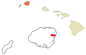
mapsize =
map_caption = Location in Kauai County and the state ofHawaii
mapsize1 =
map_caption1 =
image_dot_
dot_mapsize =
dot_map_caption =
dot_x =
dot_y =
pushpin_
pushpin_label_position =
pushpin_map_caption =
pushpin_mapsize =
subdivision_type = Country
subdivision_name =United States
subdivision_type1 = State
subdivision_name1 =Hawaii
subdivision_type2 = County
subdivision_name2 = Kauai
subdivision_type3 =
subdivision_name3 =
subdivision_type4 =
subdivision_name4 =
government_footnotes =
government_type =
leader_title =
leader_name =
leader_title1 =
leader_name1 =
leader_title2 =
leader_name2 =
leader_title3 =
leader_name3 =
leader_title4 =
leader_name4 =
established_title =
established_date =
established_title2 =
established_date2 =
established_title3 =
established_date3 =
area_magnitude =
unit_pref = Imperial
area_footnotes =
area_total_km2 = 25.9
area_land_km2 = 25.3
area_water_km2 = 0.6
area_total_sq_mi = 10.0
area_land_sq_mi = 9.8
area_water_sq_mi = 0.2
area_water_percent =
area_urban_km2 =
area_urban_sq_mi =
area_metro_km2 =
area_metro_sq_mi =
area_blank1_title =
area_blank1_km2 =
area_blank1_sq_mi =
population_as_of = 2000
population_footnotes =
population_note =
population_total = 9472
population_density_km2 = 375.0
population_density_sq_mi = 971.2
population_metro =
population_density_metro_km2 =
population_density_metro_sq_mi =
population_urban =
population_density_urban_km2 =
population_density_urban_sq_mi =
population_blank1_title =
population_blank1 =
population_density_blank1_km2 =
population_density_blank1_sq_mi =
timezone = Hawaii-Aleutian
utc_offset = -10
timezone_DST =
utc_offset_DST =
latd = 22
latm = 5
lats = 18
latNS = N
longd = 159
longm = 20
longs = 16
longEW = W
elevation_footnotes =
elevation_m = 6
elevation_ft = 20
postal_code_type =ZIP code
postal_code = 96746
area_code = 808
blank_name = FIPS code
blank_info = 15-28850
blank1_name = GNIS feature ID
blank1_info = 0360457
website =
footnotes = Kapaokinaa (Hawaiian language /dialect : Tapaokinaa) is acensus-designated place (CDP) in Kauaokinai County, Hawaiokinai,United States . The population was 9,472 at the 2000 census.The town has a large concentration of hotels, shopping centers, and tourist-oriented shops and restaurants. Unfortunately, it also has the worst
traffic congestion on the island of Kauaokinai, with a regular mainland-stylerush hour each afternoon. The state government has built an inland bypass road and implemented acontraflow lane reversal program ; these measures have only partially alleviated the traffic problems.History
Kapaokinaa literally means "the solid" in Hawaiian (a reference to a rock quarry on Ookinaahu that shares the same name) [Cite book | author=Pukui, Mary Kawena | authorlink= | coauthors= | title=Place Names of Hawaii | date= | publisher=University of Hawaii Press | location= | isbn=0-8248-0524-0 | pages=] . It is located in the ancient district of Puna, in the Kapaokinaa ahupuaokinaa or county. Ahupuaokinaa were pie shaped wedges of land that stretched from mountain to sea allowing its inhabitants the full range of landscapes and climates. The famous "Sleeping Giant" or Nounou Mountain overlooks the town. Agriculture was a big industry throughout most of the 19th and 20th centuries. Sugar cane was grown along with the largest pineapple fields on Kauai. A pineapple cannery was located where the Pono Kai condominiums now stand.
Geography
Kapaokinaa is located at coor dms|22|5|18|N|159|20|16|W|city (22.088281, -159.337706)GR|1.
According to the
United States Census Bureau , the CDP has a total area of 10.0square mile s (25.9km² ), of which, 9.8 square miles (25.3 km²) of it is land and 0.2 square miles (0.6 km²) of it (2.40%) is water.Demographics
As of the
census GR|2 of 2000, there were 9,471 people, 3,129 households, and 2,281 families residing in the CDP. Thepopulation density was 971.2 people per square mile (375.1/km²). There were 3,632 housing units at an average density of 372.4/sq mi (143.8/km²). The racial makeup of the CDP was 27.81% White, 0.34% African American, 0.52% Native American, 31.67% Asian, 9.95% Pacific Islander, 1.00% from other races, and 28.72% from two or more races. Hispanic or Latino of any race were 9.46% of the population.There were 3,129 households out of which 40.6% had children under the age of 18 living with them, 51.1% were married couples living together, 15.0% had a female householder with no husband present, and 27.1% were non-families. 20.4% of all households were made up of individuals and 6.2% had someone living alone who was 65 years of age or older. The average household size was 2.99 and the average family size was 3.44.
In the CDP the population was spread out with 29.8% under the age of 18, 7.8% from 18 to 24, 29.3% from 25 to 44, 22.8% from 45 to 64, and 10.4% who were 65 years of age or older. The median age was 35 years. For every 100 females there were 98.2 males. For every 100 females age 18 and over, there were 94.9 males.
The median income for a household in the CDP was $39,448, and the median income for a family was $45,878. Males had a median income of $30,129 versus $25,680 for females. The
per capita income for the CDP was $16,878. About 14.1% of families and 15.7% of the population were below thepoverty line , including 18.6% of those under age 18 and 12.6% of those age 65 or over.ee also
*
Blossoming Lotus References
External links
Wikimedia Foundation. 2010.