- Oakhanger, Hampshire
-
Coordinates: 51°06′54″N 0°54′10″W / 51.11508°N 0.90283°W
Oakhanger 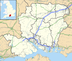
 Oakhanger
Oakhanger shown within HampshireOS grid reference SU769359 Parish Selborne District East Hampshire Shire county Hampshire Region South East Country England Sovereign state United Kingdom Post town BORDON Postcode district GU35 Police Hampshire Fire Hampshire Ambulance South Central EU Parliament South East England Website http://www.Oakhanger.org.uk List of places: UK • England • Hampshire Oakhanger is a village in the East Hampshire district of Hampshire, England. It lies 1.7 mi (2.7 km) west from Bordon, south of the B3004 road. The village has one pub, The Red Lion. A Roman road passed through the village but there are no visible signs of its existence. On its path is built a large space satellite tracking station at the south end of the village. This is in marked contrast to the thatched 18th Century cottages adjacent.[1]
The village's notable places include St. Mary Magdalene church and the former RAF station, RAF Oakhanger, is in the village, now privately run.
The nearest railway station is Alton, 3.8 mi (6.1 km) northwest of the village.
References
External links
- The Village of Oakhanger (Selborne Parish Council)
- Hampshire Treasures Page 284
- Hampshire Treasures Page 287
- Hampshire Treasures Page 290
- Hampshire Treasures Page 291
- Stained Glass Windows at St. Mary Magdalene Oakhanger, Hampshire
Towns, villages and hamlets in the East Hampshire District of Hampshire, England 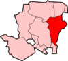 Adhurst · Alton · Arford · Ashley · Barford · Beech · Bentley · Bentworth · Binsted · Blackmoor · Blacknest · Blendworth · Bordean · Bordon · Bradley · Bramshott · Bucks Horn Oak · Buriton · Burkham · Catherington · Chalton · Chawton · Clanfield · Cold Ash Hill · Colemore · Conford · Ditcham · Durford Wood · East Meon · East Tisted · East Worldham · Empshott · Farringdon · Finchdean · Flexcombe · Four Marks · Froxfield Green · Froyle · Golden Pot · Grayshott · Greatham · Griggs Green · Hartley Mauditt · Hawkley · Headley · Headley Down · High Cross · Holybourne · Hollywater · Horndean · Idsworth · Isington · Kingsley · Kitwood · Langrish · Lasham · Lindford · Liphook · Liss · Liss Forest · Longmoor · Lovedean · Lower Wield · Medstead · Monkwood · Neatham · Newton Valence · North Street · Nursted · Oakhanger · Oakshott · Passfield · Petersfield · Priors Dean · Privett · Ramsdean · Ropley · Ropley Dean · Rowland's Castle · Selborne · Shalden · Sheet · Sleaford · Soldridge · South Hay · Southrope · Standford · Stansted · Steep · Steep Marsh · Stroud · Thedden · Upper Wield · West Liss · West Tisted · West Worldham · Weston · Wheatley · Whitehill · Wivelrod · WyckCategories:
- Villages in Hampshire
- Hampshire geography stubs
- East Hampshire


Wikimedia Foundation. 2010.