- Oare, Somerset
-
Coordinates: 51°12′N 3°43′W / 51.20°N 3.71°W
Oare 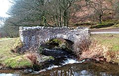
Robber's Bridge
 Oare
Oare
Oare shown within SomersetPopulation 68 [1] OS grid reference SS8047 District West Somerset Shire county Somerset Region South West Country England Sovereign state United Kingdom Postcode district TA24 Police Avon and Somerset Fire Devon and Somerset Ambulance South Western EU Parliament South West England UK Parliament Bridgwater and West Somerset List of places: UK • England • Somerset Oare is a village and civil parish on Oare Water on Exmoor in the West Somerset district of Somerset, England. The parish includes the hamlet of Oareford and the village of Culbone which contains its own tiny church.
Contents
History
The village was known as Are in the Domesday Book of 1086. After the Norman Conquest the manor was granted to Ralph de Pomeray. Later it was held by the Kelly family.[2]
Oare was part of the hundred of Carhampton.[3]
Governance
The parish council has responsibility for local issues, including setting an annual precept (local rate) to cover the council’s operating costs and producing annual accounts for public scrutiny. The parish council evaluates local planning applications and works with the local police, district council officers, and neighbourhood watch groups on matters of crime, security, and traffic. The parish council's role also includes initiating projects for the maintenance and repair of parish facilities, as well as consulting with the district council on the maintenance, repair, and improvement of highways, drainage, footpaths, public transport, and street cleaning. Conservation matters (including trees and listed buildings) and environmental issues are also the responsibility of the council.
The village falls within the Non-metropolitan district of West Somerset, which was formed on 1 April 1974 under the Local Government Act 1972, having previously been part of Williton Rural District.[4] The district council is responsible for local planning and building control, local roads, council housing, environmental health, markets and fairs, refuse collection and recycling, cemeteries and crematoria, leisure services, parks, and tourism.
Somerset County Council is responsible for running the largest and most expensive local services such as education, social services, libraries, main roads, public transport, policing and fire services, trading standards, waste disposal and strategic planning.
As Oare falls within the Exmoor National Park some functions normally administered by district or county councils have, since 1997, fallen under the Exmoor National Park Authority, which is known as a ‘single purpose’ authority, which aims to "conserve and enhance the natural beauty, wildlife and cultural heritage of the National Parks" and "promote opportunities for the understanding and enjoyment of the special qualities of the Parks by the public",[5] including responsibility for the conservation of the historic environment.[6]
It is also part of the Bridgwater and West Somerset county constituency represented in the House of Commons of the Parliament of the United Kingdom. It elects one Member of Parliament (MP) by the first past the post system of election, and part of the South West England constituency of the European Parliament which elects seven MEPs using the d'Hondt method of party-list proportional representation.
Geography
Oare is located within the Oare valley, part of the wider East Lyn Valley. Within the parish is Glenthorne a geological Site of Special Scientific Interest which is a Geological Conservation Review site because of the Trentishoe Formation of the Hangman Sandstone Group. The Hangman Sandstone represents the Middle Devonian sequence of North Devon and Somerset.[7] These unusual freshwater deposits in the Hangman Grits, which were mainly formed in desert conditions.[8]
Landmarks
Several bridges are prominent. Oare bridge is an 18th century road bridge over Oare Water,[9] and the 17th century packhorse Malmsmead Bridge over Badgworthy Water.[10] Robber's Bridge is an old masonry arch bridge in the royal forest of Exmoor[11], carrying the minor road from Porlock Hill to Oare. It crosses Weir Water and is located down a steep, wooded lane beneath overhanging trees.[12]
Religious sites
The Church of St Mary dates from the 15th century and has been designated by English Heritage as a Grade II* listed building.[13]
Cultural references
The fictional wedding of Lorna Doone in R.D. Blackmore's novel was set in the Church of St Mary after Blackmore's grandfather had been the rector from 1809-1942.[2]
References
- ^ "West Somerset". Parish Population Estimates for 2002. Somerset County Council. http://www.webcitation.org/5lRyCc5hq. Retrieved 13 December 2009.
- ^ a b Bush, Robin (1994). Somerset: The complete guide. Wimborne: The Dovecote Press Ltd. pp. 160. ISBN 1874336261.
- ^ "Carhampton Hundred". Domesday Map. http://www.domesdaymap.co.uk/hundred/carhampton/. Retrieved 23 September 2011.
- ^ A Vision of Britain Through Time : Williton Rural District
- ^ "The Authority". Exmoor National Park. http://www.exmoor-nationalpark.gov.uk/index/living_in/the_authority.htm. Retrieved 29 November 2007.
- ^ "Exmoor National Park NMP". English Heritage. http://www.english-heritage.org.uk/server/show/nav.00100200300400200300l. Retrieved 29 November 2007.
- ^ English Nature web side for the site
- ^ "Geology". Exmoor National Park. http://www.exmoor-nationalpark.gov.uk/index/learning_about/looking_after_landscape/geology.htm. Retrieved 15 November 2008.
- ^ "Oare bridge at NGR SS 8020". Images of England. English Heritage. http://www.imagesofengland.org.uk/Details/Default.aspx?id=265453. Retrieved 1 February 2009.
- ^ "Malmsmead Bridge at NGR SS 7919 4770". Images of England. English Heritage. http://www.imagesofengland.org.uk/Details/Default.aspx?id=265451. Retrieved 1 February 2009.
- ^ Everything Exmoor
- ^ Info @ Britain Express.com
- ^ "Church of St Mary". Images of England. http://www.imagesofengland.org.uk/Details/Default.aspx?id=265452. Retrieved 13 March 2008.
External links
 Media related to Oare, Somerset at Wikimedia Commons
Towns, villages and hamlets in the West Somerset district of Somerset, England 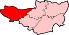 Allerford · Ashbeer · Bicknoller · Brandish Street · Brompton Ralph · Brompton Regis · Brushford · Carhampton · Clatworthy · Cockercombe · Crowcombe · Culbone · Cutcombe · Dulverton · Dunster · East Quantoxhead · Elworthy · Exford · Exton · Holford · Huish Champflower · Kilve · Lilstock · Luccombe · Luxborough · Minehead · Monksilver · Oare · Old Cleeve · Porlock · Roadwater · Sampford Brett · Selworthy · Simonsbath · Skilgate · Stogumber · Stogursey · Stringston · Timberscombe · Treborough · Upton · Washford · Watchet · West Quantoxhead · Williton · Winsford · Withycombe · Withypool · Wootton CourtenayCategories:
- Villages in West Somerset
- Exmoor
- Civil parishes in Somerset


Wikimedia Foundation. 2010.