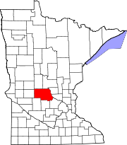
- Melrose Township, Stearns County, Minnesota
-
Melrose Township, Minnesota — Township — Location within the state of Minnesota
 Melrose Township, Minnesota
Coordinates: 45°42′57″N 94°49′47″W / 45.71583°N 94.82972°WCoordinates: 45°42′57″N 94°49′47″W / 45.71583°N 94.82972°W Country United States State Minnesota County Stearns Area – Total 40.3 sq mi (104.4 km2) – Land 39.6 sq mi (102.7 km2) – Water 0.7 sq mi (1.7 km2) Elevation 1,260 ft (384 m) Population (2000) – Total 772 – Density 19.5/sq mi (7.5/km2) Time zone Central (CST) (UTC-6) – Summer (DST) CDT (UTC-5) ZIP code 56352 Area code(s) 320 FIPS code 27-41588[1] GNIS feature ID 0664954[2] Melrose Township is a township in Stearns County, Minnesota, United States. The population was 772 at the 2000 census.
Geography
According to the United States Census Bureau, the township has a total area of 40.3 square miles (104.4 km²), of which, 39.7 square miles (102.7 km²) of it is land and 0.7 square miles (1.7 km²) of it (1.66%) is water.
Demographics
At the 2000 census[1], there were 772 people, 255 households and 207 families residing in the township. The population density was 19.5 per square mile (7.5/km²). There were 281 housing units at an average density of 7.1/sq mi (2.7/km²). The racial makeup of the township was 99.09% White, 0.13% Native American, 0.26% Asian, 0.39% from other races, and 0.13% from two or more races. Hispanic or Latino of any race were 0.39% of the population.
There were 255 households of which 42.0% had children under the age of 18 living with them, 73.3% were married couples living together, 2.4% had a female householder with no husband present, and 18.8% were non-families. 14.9% of all households were made up of individuals and 7.5% had someone living alone who was 65 years of age or older. The average household size was 3.03 and the average family size was 3.41.
Age distribution was 31.0% under the age of 18, 7.8% from 18 to 24, 27.3% from 25 to 44, 19.3% from 45 to 64, and 14.6% who were 65 years of age or older. The median age was 36 years. For every 100 females there were 111.5 males. For every 100 females age 18 and over, there were 121.2 males.
The median household income was $42,589, and the median family income was $45,865. Males had a median income of $28,571 versus $22,396 for females. The per capita income for the township was $16,462. About 3.9% of families and 5.7% of the population were below the poverty line, including 5.8% of those under age 18 and 5.7% of those age 65 or over.
References
- ^ a b "American FactFinder". United States Census Bureau. http://factfinder.census.gov. Retrieved 2008-01-31.
- ^ "US Board on Geographic Names". United States Geological Survey. 2007-10-25. http://geonames.usgs.gov. Retrieved 2008-01-31.
Municipalities and communities of Stearns County, Minnesota Cities Albany | Avon | Belgrade | Brooten‡ | Clearwater‡ | Cold Spring | Eden Valley‡ | Elrosa | Freeport | Greenwald | Holdingford | Kimball | Lake Henry | Meire Grove | Melrose | New Munich | Paynesville | Richmond | Rockville | Roscoe | Sartell‡ | Sauk Centre | Spring Hill | St. Anthony | St. Augusta | St. Cloud‡ | St. Joseph | St. Martin | St. Rosa | St. Stephen | Waite Park
Townships Albany | Ashley | Avon | Brockway | Collegeville | Crow Lake | Crow River | Eden Lake | Fair Haven | Farming | Getty | Grove | Holding | Krain | Lake George | Lake Henry | Le Sauk | Luxemburg | Lynden | Maine Prairie | Melrose | Millwood | Munson | North Fork | Oak | Paynesville | Raymond | Sauk Centre | Spring Hill | St. Joseph | St. Martin | St. Wendel | Wakefield | Zion
Footnotes ‡This populated place also has portions in an adjacent county or counties
Categories:- Townships in Stearns County, Minnesota
- St. Cloud metropolitan area


Wikimedia Foundation. 2010.