- Chesterfield, New Hampshire
-
Chesterfield, New Hampshire — Town — Main Street in 1909 Location in Cheshire County, New Hampshire
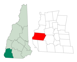
Coordinates: 42°53′14″N 72°28′13″W / 42.88722°N 72.47028°WCoordinates: 42°53′14″N 72°28′13″W / 42.88722°N 72.47028°W Country United States State New Hampshire County Cheshire Incorporated 1752 Government – Board of Selectmen Jon McKeon, Chairman
Robert Brockmann
Cliff EmeryArea – Total 47.6 sq mi (123.2 km2) – Land 45.6 sq mi (118.0 km2) – Water 2.0 sq mi (5.2 km2) 4.21% Elevation 853 ft (260 m) Population (2010) – Total 3,604 – Density 75.7/sq mi (29.2/km2) Time zone Eastern (UTC-5) – Summer (DST) Eastern (UTC-4) ZIP code 03443 Area code(s) 603 FIPS code 33-12260 GNIS feature ID 0873565 Website www.nhchesterfield.com Chesterfield is a town in Cheshire County, New Hampshire, United States. The population was 3,604 at the 2010 census.[1] It includes the village of Spofford. Chesterfield is home to Spofford Lake, Chesterfield Gorge Natural Area, and parts of Pisgah State Park and Wantastiquet Mountain State Forest.
Contents
History
Granted in 1735 by Governor Jonathan Belcher of Massachusetts, this town was the site of Fort Number 1, first in the line of forts bordering the Connecticut River. After New Hampshire became a separate province, the town would be incorporated in 1752 by Governor Benning Wentworth as Chesterfield, named for Philip Stanhope, 4th Earl of Chesterfield. Settled in 1761, the town contains some of the finest farmland in Cheshire County, yet once was home to small manufacturing, notably spinning wheel parts and handtools.[2]
In 1772, Philip Embury conducted the first Methodist religious services in New Hampshire at the James Robertson farm in Chesterfield, and in 1803, Francis Asbury preached here. Asbury Church is listed on the National Register of Historic Places and is recognized for its historic puritan design. Asbury Church is considered the "Mother Church of Methodism" in New Hampshire, and is the oldest Methodist church in New Hampshire. The town has had continual Methodist Sunday services for over 225 years.[3]
Chesterfield Academy, established in 1794, was for decades one of the most celebrated in the state.[4] Spofford Lake is one of the region's largest and oldest resorts.
-

Granite Cottage in 1907, Spofford Lake
-

Summer cottages on Spofford Lake in 1917
-

Pine Grove Springs Hotel, Spofford Lake in 1913
Geography
According to the United States Census Bureau, the town has a total area of 47.6 square miles (123 km2), of which 45.6 sq mi (118 km2) is land and 2.0 sq mi (5.2 km2) (4.21%) is water. Chesterfield is bounded on the west by the Connecticut River. The highest point in the town is near its southern border, atop Davis Hill, at 1,427 feet (435 m) above sea level. Chesterfield lies fully within the Connecticut River watershed.[5]
The town is served by state routes 9 and 63.
Demographics
As of the census[6] of 2000, there were 3,542 people, 1,366 households, and 1,005 families residing in the town. The population density was 77.7 people per square mile (30.0/km²). There were 1,632 housing units at an average density of 35.8 per square mile (13.8/km²). The racial makeup of the town was 97.80% White, 0.23% African American, 0.56% Native American, 0.17% Asian, 0.08% from other races, and 1.16% from two or more races. Hispanic or Latino of any race were 0.56% of the population.
There were 1,366 households out of which 32.7% had children under the age of 18 living with them, 63.5% were married couples living together, 6.9% had a female householder with no husband present, and 26.4% were non-families. 20.4% of all households were made up of individuals and 6.6% had someone living alone who was 65 years of age or older. The average household size was 2.59 and the average family size was 3.01.
In the town the population was spread out with 25.9% under the age of 18, 4.9% from 18 to 24, 27.9% from 25 to 44, 30.4% from 45 to 64, and 10.9% who were 65 years of age or older. The median age was 40 years. For every 100 females there were 103.8 males. For every 100 females age 18 and over, there were 100.2 males.
The median income for a household in the town was $51,351, and the median income for a family was $58,516. Males had a median income of $44,087 versus $26,547 for females. The per capita income for the town was $25,051. About 4.9% of families and 4.5% of the population were below the poverty line, including 4.5% of those under age 18 and 6.4% of those age 65 or over.
Sites of interest
Notable inhabitants
- Theodore Davis, merchant, surveyor and politician
- William H. Haile, businessman and politician
- Larkin Goldsmith Mead, sculptor
- Harlan Fiske Stone, chief justice
- Winthrop E. Stone, professor and college president
- Charles Tazewell, children's author
- Hoyt Henry Wheeler, judge
References
- ^ United States Census Bureau, American FactFinder, 2010 Census figures. Retrieved March 23, 2011.
- ^ Coolidge, Austin J.; John B. Mansfield (1859). A History and Description of New England. Boston, Massachusetts. pp. 444–445. http://books.google.com/books?id=OcoMAAAAYAAJ&lpg=PA9&dq=coolidge%20mansfield%20history%20description%20new%20england%201859&pg=PA444#v=onepage&q&f=false.
- ^ History of Asbury United Methodist Church
- ^ History of Chesterfield, Cheshire County, New Hampshire
- ^ Foster, Debra H.; Batorfalvy, Tatianna N.; and Medalie, Laura (1995). Water Use in New Hampshire: An Activities Guide for Teachers. U.S. Department of the Interior and U.S. Geological Survey. http://nh.water.usgs.gov/Publications/nh.intro.html.
- ^ "American FactFinder". United States Census Bureau. http://factfinder.census.gov. Retrieved 2008-01-31.
External links
- Town website
- Chesterfield Public Library
- Chesterfield Historical Society
- New Hampshire Economic and Labor Market Information Bureau Profile
Municipalities and communities of Cheshire County, New Hampshire City 
Towns Alstead | Chesterfield | Dublin | Fitzwilliam | Gilsum | Harrisville | Hinsdale | Jaffrey | Marlborough | Marlow | Nelson | Richmond | Rindge | Roxbury | Stoddard | Sullivan | Surry | Swanzey | Troy | Walpole | Westmoreland | Winchester
Villages Ashuelot | Chesham | Drewsville | East Swanzey | North Walpole | Poocham | Spofford | West Swanzey
Categories:- Towns in Cheshire County, New Hampshire
- Populated places on the Connecticut River
-


Wikimedia Foundation. 2010.