- Englishtown, New Jersey
Infobox Settlement
official_name = Englishtown, New Jersey
settlement_type = Borough
nickname =
motto =
imagesize =
image_caption =
image_
imagesize =
image_caption =
image_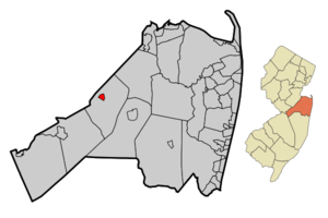
mapsize = 250x200px
map_caption = Map of Englishtown in Monmouth County. Inset: Location of Monmouth County highlighted in the State of New Jersey.
mapsize1 = 250x200px
map_caption1 = Census Bureau map of Englishtown, New Jerseysubdivision_type = Country
subdivision_name =United States
subdivision_type1 = State
subdivision_name1 =New Jersey
subdivision_type2 = County
subdivision_name2 = Monmouth
government_footnotes =
government_type = Borough
leader_title = Mayor
leader_name = Thomas Reynolds
leader_title1 =
leader_name1 =
established_title = Incorporated
established_date =January 4 ,1888 unit_pref = Imperial
area_footnotes =
area_magnitude =
area_total_km2 = 1.5
area_land_km2 = 1.5
area_water_km2 = 0.0
area_total_sq_mi = 0.6
area_land_sq_mi = 0.6
area_water_sq_mi = 0.0population_as_of = 2006
population_footnotes =
population_total = 1841
population_density_km2 = 1197.7
population_density_sq_mi = 3102.1timezone = Eastern (EST)
utc_offset = -5
timezone_DST = EDT
utc_offset_DST = -4
elevation_footnotes = [Gnis|885211|Borough of Englishtown,Geographic Names Information System , accessedOctober 24 ,2007 .]
elevation_m = 21
elevation_ft = 69
latd = 40 |latm = 17 |lats = 45 |latNS = N
longd = 74 |longm = 21 |longs = 35 |longEW = Wpostal_code_type =
ZIP code
postal_code = 07726
area_code = 732
blank_name = FIPS code
blank_info = 34-21570GR|2 [ [http://mcdc2.missouri.edu/webrepts/commoncodes/ccc_nj.html A Cure for the Common Codes: New Jersey] , Missouri Census Data Center. AccessedJuly 14 ,2008 .]
blank1_name = GNIS feature ID
blank1_info = 0885211GR|3
website = http://www.englishtownnj.com
footnotes =Englishtown is a Borough in Monmouth County,
New Jersey ,United States . As of theUnited States 2000 Census , the borough population was 1,764.Englishtown was incorporated as a borough by an Act of the
New Jersey Legislature onJanuary 4 ,1888 , from portions of Manalapan Township, based on the results of a referendum held the previous day."The Story of New Jersey's Civil Boundaries: 1606-1968", John P. Snyder, Bureau of Geology and Topography; Trenton, New Jersey; 1969. p. 179.]Geography
Englishtown is located at coor dms|40|17|45|N|74|21|35|W|city (40.295965, -74.359821)GR|1.
According to the
United States Census Bureau , the borough has a total area of 0.6square mile s (1.5km² ), of which, 0.6 square miles (1.5 km²) of it is land and 1.72% is water.Englishtown is an enclave of (that is, it is entirely surrounded by) the Township of Manalapan.
Demographics
USCensusPop
1930=797
1940=815
1950=1004
1960=1143
1970=1048
1980=976
1990=1268
2000=1764
estimate= 1841
estyear=2006
estref= [http://factfinder.census.gov/servlet/SAFFPopulation?_event=Search&_name=englishtown&_state=04000US34&_county=englishtown&_cityTown=englishtown&_zip=&_sse=on&_lang=en&pctxt=fph Census data for Englishtown borough] ,United States Census Bureau . AccessedSeptember 1 ,2007 .]
footnote=Population 1930 - 1990. [ [http://www.wnjpin.net/OneStopCareerCenter/LaborMarketInformation/lmi01/poptrd6.htm New Jersey Resident Population by Municipality: 1930 - 1990] , Workforce New Jersey Public Information Network. AccessedMarch 1 ,2007 .] As of thecensus GR|2 of 2000, there were 1,764 people, 643 households, and 416 families residing in the borough. Thepopulation density was 3,102.1 people per square mile (1,194.9/km²). There were 680 housing units at an average density of 1,195.8/sq mi (460.6/km²). The racial makeup of the borough was 88.38% White, 4.14% African American, 0.11% Native American, 4.48% Asian, 1.64% from other races, and 1.25% from two or more races. Hispanic or Latino of any race were 6.24% of the population.There were 643 households out of which 39.5% had children under the age of 18 living with them, 51.8% were married couples living together, 10.0% had a female householder with no husband present, and 35.3% were non-families. 28.5% of all households were made up of individuals and 14.3% had someone living alone who was 65 years of age or older. The average household size was 2.74 and the average family size was 3.51.
In the borough the population was spread out with 29.1% under the age of 18, 6.0% from 18 to 24, 36.5% from 25 to 44, 17.5% from 45 to 64, and 11.0% who were 65 years of age or older. The median age was 35 years. For every 100 females there were 91.5 males. For every 100 females age 18 and over, there were 82.4 males.
The median income for a household in the borough was $57,557, and the median income for a family was $73,750. Males had a median income of $50,694 versus $33,068 for females. The
per capita income for the borough was $23,438. About 4.0% of families and 7.2% of the population were below thepoverty line , including 5.7% of those under age 18 and 13.4% of those age 65 or over.Government
Local government
Englishtown operates under the Borough form of New Jersey municipal government, and is governed by a mayor and a six-member borough council. The mayor is directly elected by the voters to a four-year term of office. Borough council members serve three-year terms on a staggered basis, with two seats coming up for election each year. ["2005 New Jersey Legislative District Data Book",
Rutgers University Edward J. Bloustein School of Planning and Public Policy , April 2005, p. 63.]The mayor of the Borough of Englishtown is Thomas Reynolds. Members of the Englishtown Borough Council are Council President Harry Soden, Jayne Carr, Lori Cooke, Janet Leonardis, Cindy Robilotti and Steven Simon. [ [http://www.englishtownnj.com/twncon03.htm Englishtown Borough Council] , Borough of Englishtown. Accessed
April 28 ,2008 .]Federal, state and county representation
Englishtown is in the Twelfth Congressional District and is part of New Jersey's 12th Legislative District. [ [http://www.lwvnj.org/pubs/CG06.pdf 2006 New Jersey Citizen's Guide to Government] , New Jersey
League of Women Voters , p. 57. AccessedAugust 30 ,2006 .]Education
Public school students in grades K - 8 attend the
Manalapan-Englishtown Regional School District , which also serves children from Manalapan Township. Over 90% of the district's students are from Manalapan. Schools in the district (with 2005-06 enrollment from theNational Center for Education Statistics [ [http://nces.ed.gov/ccd/schoolsearch/school_list.asp?Search=1&DistrictID=3409390 Data for the Manalapan-Englishtown Regional School District] ,National Center for Education Statistics . AccessedApril 28 ,2008 .] ) are [http://www.mers.k12.nj.us/education/school/school.php?sectionid=4 John I. Dawes Early Learning Center] for preschool; [http://www.mers.k12.nj.us/education/school/school.php?sectionid=3 Clark Mills] (747 students), [http://www.mers.k12.nj.us/education/school/school.php?sectionid=7 Milford Brook] (737) and [http://www.mers.k12.nj.us/education/school/school.php?sectionid=9 Taylor Mills] (670) for grades K-3; [http://www.mers.k12.nj.us/education/school/school.php?sectionid=5 Lafayette Mills] (527), [http://www.mers.k12.nj.us/education/school/school.php?sectionid=8 Pine Brook] (830) and [http://www.mers.k12.nj.us/education/school/school.php?sectionid=10 Wemrock Brook] (564) for grades 4-6; and [http://www.mers.k12.nj.us/education/school/school.php?sectionid=6 Manalapan-Englishtown Middle School (MEMS)] (1,420) for grades 7 and 8.Students in public school for grades 9-12 attend
Manalapan High School , as part of theFreehold Regional High School District . The Freehold Regional High School District serves students from Colts Neck Township, Englishtown, Farmingdale, Freehold Borough, Freehold Township, Howell Township, Manalapan Township and Marlboro. [ [http://education.state.nj.us/rc/rc07/narrative/25/1650/25-1650-000.html Freehold Regional High School District 2007 Report Card Narrative] ,New Jersey Department of Education . AccessedApril 28 ,2008 . "Freehold Regional High School District, the largest high school district in New Jersey, has six high schools with almost 12,000 students and over 1,500 employees.... District members include the Townships of Colts Neck, Freehold, Howell, Manalapan, and Marlboro, and the Boroughs of Englishtown, Farmingdale, and Freehold."]History
At the
Battle of Monmouth , American General Charles Lee led the advance and initiated the first attack on the column's rear. When the British turned to flank him, he ordered a general retreat without so as much as firing a shot at the enemy, and his soldiers soon became disorganized. In the dining room of the Village Inn, located in the center of Englishtown, General Washington and Lord Stirling drew up the court martial papers citing Lee for his conduct during and after the battle. [ [http://www.englishtownnj.com/history.htm A Short History of the Borough of Englishtown] , Borough of Englishtown. AccessedDecember 26 ,2006 .]Transportation
New Jersey Transit bus service to thePort Authority Bus Terminal inMidtown Manhattan is available on the 139 route. [ [http://www.njtransit.com/sf_tp_rc_monmouth.shtml Monmouth County Bus/Rail Connections] ,New Jersey Transit . AccessedJuly 3 ,2007 .]County Route 527 passes through the borough. [ [http://www.state.nj.us/transportation/refdata/sldiag/00000527__-.pdf NJDOT County Route 527 Straight Line Diagram (PDF)] ,
New Jersey Department of Transportation . AccessedJuly 1 ,2008 .]Old Bridge Airport and Mar Bar L Farms municipal airport are within 2½ of Englishtown, and supply short-distance flights to surrounding areas.Points of interest
*
Old Bridge Township Raceway Park Notable residents
Notable current and former residents of Englishtown include:
*Ed Krawiec (1976-),NHRA Pro Stock Motorcycle racer, is an Englishtown native and resident. [ [http://www.nhra.com/stats/pointsdtl.asp?an=358250&cc=12&se=2007&tt=1&dn=Ed%20Krawiec&ct=Englishtown&st=NJ&rn=88&pt=2156 Points Detail for Ed Krawiec] ,NHRA . AccessedOctober 24 ,2007 .]References
External links
* [http://www.englishtownnj.com/ Englishtown website]
* [http://www.racewaypark.com/ Old Bridge Township Raceway Park]
* [http://www.mers.k12.nj.us/ Manalapan Englishtown Regional School District]
*NJReportCard|25|2920|0|Manalapan-Englishtown Regional School District
* [http://nces.ed.gov/ccd/schoolsearch/school_list.asp?Search=1&DistrictID=3409390 Data for the Manalapan-Englishtown Regional School District] ,National Center for Education Statistics
* [http://www.frhsd.com/freeholdtwp/ Colts Neck High School]
* [http://www.frhsd.com Freehold Regional High School District]
*NJReportCard|25|1650|0|Freehold Regional High School District
* [http://nces.ed.gov/ccd/schoolsearch/school_list.asp?Search=1&DistrictID=3405610 Data for the Freehold Regional High School District] ,National Center for Education Statistics
Wikimedia Foundation. 2010.