- Marlbrook, Worcestershire
-
Coordinates: 52°21′48″N 2°02′27″W / 52.363384°N 2.040927°W
Marlbrook 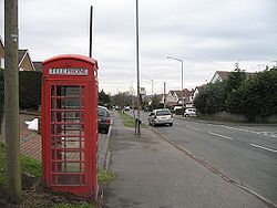
Telephone box, Upper Marlbrook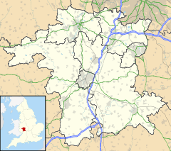
 Marlbrook
Marlbrook shown within WorcestershireOS grid reference SO973739 Parish Catshill and North Marlbrook
Lickey and Blackwell
Lickey EndDistrict Bromsgrove Shire county Worcestershire Region West Midlands Country England Sovereign state United Kingdom Post town BROMSGROVE Postcode district B61 Dialling code 0121 Police West Mercia Fire Hereford and Worcester Ambulance West Midlands EU Parliament West Midlands UK Parliament Bromsgrove List of places: UK • England • Worcestershire Marlbrook is a village in Worcestershire, England.
Towns Villages Alvechurch • Aston Fields • Barnt Green • Belbroughton • Bell End • Beoley • Blackwell • Bordesley • Bournheath • Burcot • Catshill • Clent • Charford • Cofton Hackett • Dodford • Fairfield • Finstall • Frankley • Hagley • Hollywood • Holt End • Holy Cross • Hopwood • Hunnington • Lickey • Lickey End • Marlbrook • Romsley • Rowney Green • Rubery • Sidemoor • Stoke Heath • Stoke Prior • Tardebigge • Tutnall • Upper Bentley • WythallCivil Parishes Categories:- Villages in Worcestershire
- Worcestershire geography stubs


Wikimedia Foundation. 2010.