- Chrishall
-
Coordinates: 52°01′55″N 0°06′32″E / 52.032°N 0.109°E
Chrishall 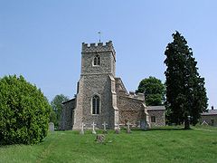
Holy Trinity Church, Chrishall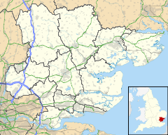
 Chrishall
Chrishall shown within EssexPopulation Approx. 600 OS grid reference TL446392 District Uttlesford Shire county Essex Region East Country England Sovereign state United Kingdom Post town ROYSTON Postcode district SG8 Dialling code 01763 Police Essex Fire Essex Ambulance East of England EU Parliament East of England List of places: UK • England • Essex Chrishall (pronounced Chris hall) is a small village in the English county of Essex. It is located 20 kilometres (12 mi) south of Cambridge and lies equidistant [10 kilometres (6 mi)] between the two medieval market towns of Saffron Walden and Royston. Although in Essex, Chrishall lies close to its borders with Hertfordshire and Cambridgeshire and has a 'Hertfordshire' postcode (SG8).
The village was listed in the Domesday Book as Cristeshalla, or "nook of land dedicated to Christ". It is one of only two English settlements whose name contains the word "Christ".[citation needed]
The Icknield Way, a Neolithic track, passes through the parish.
Chrishall's location is key to its character; as the village sits at the highest point in Essex, at 147 metres (482 ft) above sea level, road construction has avoided this high ground and therefore Chrishall is off the beaten track. Despite its relative isolation the village retains facilities such as a pre-school as well as an infant and junior school. The village also boasts a sports field, a new playground, two churches, many clubs and societies as well as the Red Cow public house.
Chrishall's population has remained largely unchanged over the last 170 years. In 1841 it totalled 518 and today about 450 people live in the village.[1]
In Where Troy Once Stood by I. Wilkens, he states,
Not only rivers, dykes and barrows are important features of the Trojan landscape, but so are hills, regions and towns. To start with, Homer mentions three famous hills in the region. Zeus, who supported the Trojans, was believed to have watched the battles from a peak of Ida, the Gargarus, where he had a sanctuary and an altar for burnt-offerings (VIII,48; XIV,292). The most likely site is the high hill (147 metres (482 ft)) of the Ditton Woods south of Cambridge which is called Chrishall in our era (Cristeshala in 1068). In our era a church was built on top of the hill where once Zeus' altar may have been.Contents
History
Following the Norman Conquest the area around Chrishall was given to Eustace of Boulogne who built and occupied a house on a hill to the south of the current church. He named the house "Flanders" and it was there that his daughter Matilda of Boulogne, later wife of King Stephen was raised. A letter survives that the queen wrote to Hubert the Chamberlain ordering that the residents of Chrishall be looked after. The house survived until the 15th century, and is believed to have stood on the site of Chiswick Hall, itself built in the 17th century by Sir John James (d.1676).[2][3]
Church
The village has been home to a church for over a thousand years. Prior to the Norman invasion a small church dedicated to the Virgin Mary was situated on the site of the present church.[2]
The current church, dedicated to the Holy Trinity, was begun in the 12th century. It consists of a nave and aisles, a chancel, and a stone tower crowned by a spire, and containing four bells. It was appropriated, at an early period, to Westminster Abbey.[3]
The church contains a number of brasses, including a notable one in memory of Sir John de la Pole and his wife, dating from 1380.[4]
Buildings
The village has a pub, church, Primary school, village hall and adventure playground.
The barn attached to the Red Cow pub is the oldest building in Chrishall apart from the church, believed to date to 1500. There was once a village shop in front of the pub, however this is now closed.
Holy Trinity Church, a 12th Century Grade I Listed Building, is situated on the edge of the main village. A comprehensive set of images and the detailed history of Holy Trinity appear on the parish website. In the centre of the village lies Chrishall Holy Trinity and St. Nicholas C of E Primary School, village hall and adventure playground.
References
- ^ http://www.chrishallpc.org.uk/
- ^ a b "Local history of Chrishall". Uttlesford History. http://www.recordinguttlesfordhistory.org.uk/chrishall/chrishall.html.
- ^ a b White (1848). Directory of Essex.
- ^ Sir John de la Pole, brass
External links
Categories:- Villages in Essex
- Uttlesford


Wikimedia Foundation. 2010.