- Stocksbridge and Upper Don
-
Stocksbridge and Upper Don 
Shown within SheffieldDistrict: Sheffield UK Parliament constituency: Penistone and Stocksbridge Ceremonial county: South Yorkshire Region: Yorkshire and the Humber Population (2001): 18,400 Councillors Philip Wood (Labour)
Alison Brelsford (Lib Dem)
Jack Clarkson (Lib Dem)Stocksbridge and Upper Don ward—which includes the districts of Deepcar, Oughtibridge, Stocksbridge, and Wharncliffe Side, and the villages of Bolsterstone, Ewden, and Midhopestones—is one of the 28 electoral wards in the City of Sheffield, South Yorkshire, England. It is located in the northwestern part of the city and covers an area of 93.2 km2. The population of this ward in 2001 was 18,400 people in 7,700 households. It is one of the wards that make up the Sheffield Hillsborough constituency up until the next general election (expected 2009-2010). At the next general election a completely new constituency will be created for this area Stocksbridge and Penistone.[citation needed]
Contents
Districts in Stocksbridge and Upper Don ward
Stocksbridge
Main article: Stocksbridge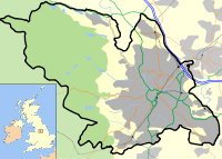
 Stocksbridge shown in Sheffield
Stocksbridge (grid reference SK275980, postal region S36) is a small town in the metropolitan borough of the City of Sheffield, with a population of around 14,000.[1]
Deepcar
Deepcar (grid reference SK289975, postal region S36) is the eastern gateway to the area and borders on Wharncliffe Crags and Wharncliffe Woods.
Evidence of a large circular Mesolithic building dating to c. 7,600 BC which is interpreted as a dwelling [1] has been identified at Deepcar.
Oughtibridge
Main article: OughtibridgeOughtibridge is a village to the south east of Stocksbridge, in the Upper Don Valley.
Wharncliffe Side
Wharncliffe Side (grid reference SK297948) is a small village on the border of the Peak District in the City of Sheffield and the Parish of Bradfield. It is a quite close knit community with a school and community centre. The river Don has cut the valley with steep sides. One side has a dense wood on it. It is half way between Oughtibridge and Stocksbridge. A legend surrounds the wood, in the past a dragon lived in the wood before a lord nearby killed it. You can visit the dragons cave to this day.
Bolsterstone
Bolsterstone is a village on the ridge to the south of Stocksbridge.
In the village churchyard lie two large stones of uncertain origin. Neville T. Sharpe supports the theory that they were moved from Unsliven Bridge in 1796, and contends that they are the base of a twin-shafted Anglo-Saxon cross.[2]
Ewden
Ewden is a village in the Ewden valley to the south of Stocksbridge, that was expanded when the Broomhead Reservoir was built across the Ewden Beck.
Midhopestones
A small village consisting of a few houses, farms, St James' Church and the "Ye Olde Mustard Pot" pub. The village is upstream of the Underbank Reservoir.
Culture
The ASDA Stocksbridge Band is one of the leading brass bands in the UK. It was formerly associated with the steel works, and appeared in the UK movie The Full Monty.
Stocksbridge is home to many traditional Yorkshire Christmas carols as is especially known for its renditions of Hail Smiling Morn. Bolsterstone Male Voice Choir is also based close by.
Three of the four members of the Arctic Monkeys were pupils at Stocksbridge High School.
Oliver Sykes, Vocalist in Bring Me the Horizon and owner of Drop Dead Clothing has lived in Stocksbridge since the age of five and attended Stocksbridge High School.
References
- ^ "Stocksbridge". http://www.stocksbridge-council.co.uk/. Retrieved 6 January 2009.
- ^ Neville T. Sharpe, Crosses of the Peak District (Landmark Collectors Library, 2002)
The City of Sheffield, England About Sheffield 
Districts of Sheffield by ward Arbourthorne · Beauchief and Greenhill · Beighton · Birley · Broomhill · Burngreave · Central · Crookes · Darnall · Dore and Totley · East Ecclesfield · Ecclesall · Firth Park · Fulwood · Gleadless Valley · Graves Park · Hillsborough · Manor Castle · Mosborough · Nether Edge · Richmond · Shiregreen and Brightside · Southey · Stannington · Stocksbridge and Upper Don · Walkley · West Ecclesfield · Woodhouse Book:Sheffield ·
  Category:Sheffield ·
  Portal:England
Ceremonial county of South Yorkshire Yorkshire Portal Metropolitan districts Major settlements Askern • Barnsley • Bawtry • Brierley • Conisbrough • Dinnington • Doncaster • Edlington • Hatfield • Hoyland • Maltby • Mexborough • Penistone • Rotherham • Sheffield • South Kirkby and Moorthorpe • Stainforth • Stocksbridge • Swinton • Thorne • Tickhill • Wath upon Dearne • Wombwell
See also: List of civil parishes in South YorkshireRivers Topics Castles • Grade I listed buildings • People • Monastic houses • Windmills • MuseumsCategories:- Ironworks and steelworks in England
- Stocksbridge
- Wards of Sheffield


Wikimedia Foundation. 2010.