- Crary, North Dakota
-
Crary, North Dakota — City — Sign at Crary Location of Crary, North Dakota
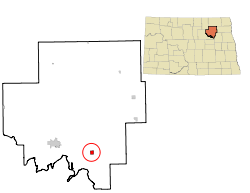
Coordinates: 48°4′N 98°38′W / 48.067°N 98.633°WCoordinates: 48°4′N 98°38′W / 48.067°N 98.633°W Country United States State North Dakota County Ramsey Founded 1884 Area – Total 0.9 sq mi (2.4 km2) – Land 0.9 sq mi (2.3 km2) – Water 0.0 sq mi (0.1 km2) Elevation 1,486 ft (453 m) Population (2010)[1] – Total 142 – Density 169.6/sq mi (65.5/km2) Time zone Central (CST) (UTC-6) – Summer (DST) CDT (UTC-5) ZIP code 58327 Area code(s) 701 FIPS code 38-16580[2] GNIS feature ID 1028528[3] Crary is a city in Ramsey County, North Dakota in the United States. The population was 142 at the 2010 census.[1] Crary was founded in 1884.
Geography
Crary is located at 48°4′N 98°38′W / 48.067°N 98.633°W (48.0696, -98.6394).[4]
According to the United States Census Bureau, the city has a total area of 0.9 square miles (2.3 km2), of which, 0.9 square miles (2.3 km2) of it is land and 0.1 square miles (0.26 km2) of it (5.43%) is water.
Demographics
Historical populations Census Pop. %± 1910 279 — 1920 307 10.0% 1930 278 −9.4% 1940 267 −4.0% 1950 235 −12.0% 1960 195 −17.0% 1970 150 −23.1% 1980 139 −7.3% 1990 145 4.3% 2000 149 2.8% 2010 142 −4.7% U.S. Decennial Census As of the census[2] of 2000, there were 149 people, 47 households, and 42 families residing in the city. The population density was 169.6 people per square mile (65.4/km²). There were 54 housing units at an average density of 61.5 per square mile (23.7/km²). The racial makeup of the city was 96.64% White, 2.68% Native American, and 0.67% from two or more races.
There were 47 households out of which 44.7% had children under the age of 18 living with them, 74.5% were married couples living together, 2.1% had a female householder with no husband present, and 10.6% were non-families. 6.4% of all households were made up of individuals and none had someone living alone who was 65 years of age or older. The average household size was 3.17 and the average family size was 3.21.
In the city the population was spread out with 33.6% under the age of 18, 8.7% from 18 to 24, 30.9% from 25 to 44, 18.8% from 45 to 64, and 8.1% who were 65 years of age or older. The median age was 32 years. For every 100 females there were 119.1 males. For every 100 females age 18 and over, there were 120.0 males.
The median income for a household in the city was $39,375, and the median income for a family was $43,125. Males had a median income of $21,250 versus $20,156 for females. The per capita income for the city was $13,084. There were 6.1% of families and 9.6% of the population living below the poverty line, including 18.9% of under eighteens and none of those over 64.
References
- ^ a b "2010 Census Redistricting Data (Public Law 94-171) Summary File". American FactFinder. United States Census Bureau. http://factfinder2.census.gov/faces/tableservices/jsf/pages/productview.xhtml?pid=DEC_10_PL_GCTPL2.ST13&prodType=table. Retrieved 2 May 2011.
- ^ a b "American FactFinder". United States Census Bureau. http://factfinder.census.gov. Retrieved 2008-01-31.
- ^ "US Board on Geographic Names". United States Geological Survey. 2007-10-25. http://geonames.usgs.gov. Retrieved 2008-01-31.
- ^ "US Gazetteer files: 2010, 2000, and 1990". United States Census Bureau. 2011-02-12. http://www.census.gov/geo/www/gazetteer/gazette.html. Retrieved 2011-04-23.
Municipalities and communities of Ramsey County, North Dakota Cities Brocket | Churchs Ferry | Crary | Devils Lake | Edmore | Hampden | Lawton | Starkweather

Townships Bartlett | Cato | Chain Lakes | Coulee | Creel | De Groat | Dry Lake | Fancher | Freshwater | Grand Harbor | Hammer | Harding | Highland Center | Hope | Klingstrup | Lawton | Lillehoff | Minnewaukan | Morris | Newbre | Newland | Noonan | North Creel | Northfield | Odessa | Ontario | Overland | Pelican | Poplar Grove | Prospect | Royal | South Minnewaukan | Stevens | Sullivan | Triumph | Webster
Unincorporated
communitiesCategories:- Cities in North Dakota
- Populated places in Ramsey County, North Dakota
- Populated places established in 1884


Wikimedia Foundation. 2010.