- Cossall
-
Coordinates: 52°58′34″N 1°16′52″W / 52.976°N 1.281°W
Cossall 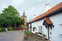
The church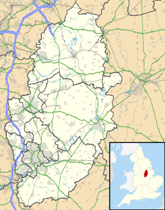
 Cossall
Cossall shown within NottinghamshireOS grid reference SK483423 District Broxtowe Shire county Nottinghamshire Region East Midlands Country England Sovereign state United Kingdom Post town NOTTINGHAM Postcode district NG16 Dialling code 0115 Police Nottinghamshire Fire Nottinghamshire Ambulance East Midlands EU Parliament East Midlands List of places: UK • England • Nottinghamshire Cossall is a hamlet in Nottinghamshire, England. It is located 1 mile east of Ilkeston. According to the 2001 census it had a population of 612[1]. To the north of the hamlet is a large hill or slag heap, produced from tons of waste extracted from the local coal mines.
See also
- Willoughby Almshouses
References
External links
 Media related to Cossall at Wikimedia CommonsCategories:
- Villages in Nottinghamshire
- Places in Broxtowe
- Nottinghamshire geography stubs


Wikimedia Foundation. 2010.