- Marys Peak
-
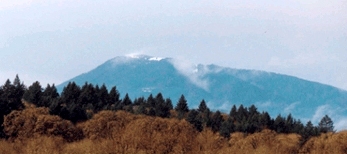
Marys Peak 
Snow covering the peak.Elevation 4,097 ft (1,249 m) NAVD 88[1] Prominence 3,357 ft (1,023 m) [2] Location Location Benton County, Oregon, USA Range Central Oregon Coast Range, Oregon Coast Range Coordinates 44°30′16″N 123°33′09″W / 44.504355950°N 123.552456264°WCoordinates: 44°30′16″N 123°33′09″W / 44.504355950°N 123.552456264°W[1] Topo map USGS Lorane Climbing Easiest route trail from Mary's Peak Road Marys Peak (formerly Mary's Peak and sometimes still spelled this way) is a mountain in Benton County, Oregon, United States, just southwest of Philomath. It is the highest peak in the Oregon Coast Range. It is also the highest point in Benton County,[3] and ranks eleventh in the state for prominence.[4]
On a clear day at the top of the peak, facing east, northeast, and southeast, one can see the cities and suburbs of the Willamette Valley, as well as the Cascade Range. To the west, the Pacific Ocean is visible on clear days.
The road to the peak now remains open in the winter. During the 2010-2011 winter the Forest Service announced they will leave the gates open to facilitate travel to the summit. The road will not be maintained so a lifted 4x4 or 4 wheel chains are required for access during the winter months. [1]
References
- ^ a b "Mary". NGS data sheet. U.S. National Geodetic Survey. http://www.ngs.noaa.gov/cgi-bin/ds_mark.prl?PidBox=QE2315. Retrieved 2008-11-01.
- ^ "Marys Peak, Oregon". Peakbagger.com. http://www.peakbagger.com/peak.aspx?pid=1080. Retrieved 2008-04-03.
- ^ "Oregon County High Points". Peakbagger.com. http://www.peakbagger.com/list.aspx?lid=13203. Retrieved 2008-11-01.
- ^ "Oregon Peaks with 2000 feet of Prominence". Peakbagger.com. http://www.peakbagger.com/list.aspx?lid=41309. Retrieved 2008-11-01.
External links
- "Marys Peak". Geographic Names Information System, U.S. Geological Survey. http://geonames.usgs.gov/pls/gnispublic/f?p=gnispq:3:::NO::P3_FID:1145860. Retrieved 2008-11-01.
Oregon Coast Range Northern - Five highest peaks: Rogers Peak
- South Saddle Mountain
- Larch Mountain
- Trask Mountain
- Saddle Mountain
Central - Five highest peaks: Marys Peak
- Grass Mountain
- Laurel Mountain
- Prairie Peak
- Saddle Bag Mountain
Southern - Four highest peaks: Bone Mountain
- Kenyon Mountain
- Bear Mountain
- Buzzard Rock
See also Categories:- Mountains of Oregon Coast Range
- Landmarks in Oregon
- Landforms of Benton County, Oregon
- Oregon geography stubs
Wikimedia Foundation. 2010.