- Mid-Govans, Baltimore
-
Coordinates: 39°21′29″N 76°36′36″W / 39.358°N 76.61°W
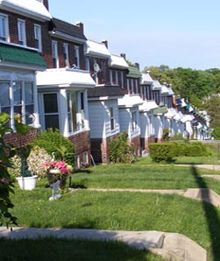 Homes in Govans, just off York Road
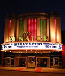 The Senator
Mid-Govans is a community in northeast Baltimore, Maryland and part of the development of York Road, a historic Baltimore route to Pennsylvania.
Contents
Points of interest
Govans includes several historically and culturally significant places of interests including: DeWees Park, Chinquapin Park, the Senator Theater, Epiphany House, Gallagher Mansion, McCabe Mansion, Homeland and Belvedere Square Shopping Centers, City Garden plots on Woodbourne Avenue, Loyola University Maryland, College of Notre Dame of Maryland and the DeWees PAL Center.[1]
Demographics
According to the 2000 US Census, 2,375 people live in Mid-Govans with 80.4% African-American and 16.4% White. The median family income is $40,948. 93% of the houses are occupied and 75.7% of those are occupied by the home's owner.[2]
Schools
Mid-Govans has four public elementary schools: Govans, Yorkwood, Leithwalk and Guildford elementary schools. The area is served by the Chinquapin Middle School. High school students generally attend in Mervo, City, DuBois or Lewis highschools.
Notes
- ^ "Govans/Mid-Govans". Live Baltimore Home Center. http://www.livebaltimore.com/nb/list/govans/. Retrieved 2008-05-05.
- ^ "Profile of General Demographic Characteristics: Mid-Govans". Baltimore City Planning Department. http://censusprofile.bnia.org/Mid-Govans%20Demographic%20Profile.pdf. Retrieved 2008-05-05.
External links
See also
Neighborhoods in Baltimore, Maryland Northwest Arlington • Ashburton • Cheswolde • Fallstaff • Forest Park • Glen • Howard • Park Heights • Pimlico • Reisterstown Station • Television Hill
North Abell • Barclay • Bellona-Gittings • Better Waverly • Cameron • Charles Village • Cedarcroft • Chinquapin Park-Belvedere • Cylburn • Edgecomb • Evergreen • Govans • Guilford • Hampden • Harwood • Homeland • Homewood • Keswick • Lake Evesham • Lake Walker • Little Korea Town • Medfield • Mount Washington • Oakenshawe • Pen Lucy • Poplar Hill • Radnor-Winston • Remington • Roland Park • Sabina Mattefeldt • Tuscany-Canterbury • Village of Cross Keys • Waverly • Woodberry • Wyman Park • Wyndhurst
Northeast Belair-Edison • Cedonia • Coldstream-Homestead-Montebello • Ednor Gardens-Lakeside • Frankford • Gardenville • Hamilton • Hillen • Lauraville • Loch Raven • Mayfield • Mid-Govans • Northwood • Ramblewood • Stonewood-Pentwood-Winston • Wilson Park • Woodbourne Heights
West Bridgeview/Greenlawn • Coppin Heights • Edmondson • Franklin Square • Harlem Park • Lexington • Mondawmin • Mosher • Poppleton • Rosemont • Sandtown - Winchester • Upton •
Walbrook • Windsor HillsCentral Barre Circle • Bolton Hill • Charles Center • Downtown • Inner Harbor • Madison Park • Mount Vernon • Otterbein • Reservoir Hill • Ridgely's Delight • Seton Hill • Station North • Westside
East Barclay • Berea • Broadway East • Coldstream-Homestead-Montebello • East Baltimore Midway • Ellwood Park • Four By Four • Greenmount West • Madison-Eastend • McElderry Park • Middle East • Oldtown-Latrobe • Oliver • Orangeville
Southwest Beechfield • Carrollton Ridge • Dickeyville • Franklintown • Gwynn's Falls • Hollins Market • Irvington • Morrell Park • Pigtown • Sowebo • Ten Hills • Union Square • Violetville • Wakefield • Washington Village • Yale Heights
South Brooklyn • Cherry Hill • Curtis Bay • Fairfield • Federal Hill • Harborview • Lakeland • Locust Point • Mount Winans • Pratt Monroe • South Baltimore • Wagner's Point • Westport
Southeast Bayview • Brewer's Hill • Butchers Hill • Canton • Fell's Point • Graceland Park • Greektown • Harbor East • Highlandtown • Jonestown • Joseph Lee • Kresson • Linwood • Little Italy • Patterson Park • St Helena • Upper Fells Point • Washington Hill
Public housing Allendale • Armistead Gardens • Bel Park Towers • Claremont • Douglass Homes • Ellerslie Homes • Flaghouse Homes • Govans Manor Homes • Heritage Crossing • Johnston Square • Lafayette Court • Latrobe Homes • Mason Homes • Lakeview Towers • McCulloh Homes • O'Donnell Heights • Perkins Homes • Pleasent View Gardens • Poe Homes • Primrose Place • Somerset Courts
Parks Clifton Park • Cylburn Arboretum • Druid Hill Park • Gwynns Falls Park • Leakin Park • Patterson Park • Sherwood Gardens • Wyman Park
Categories:- Neighborhoods in Baltimore, Maryland
- Populated places in Maryland with African American majority populations


Wikimedia Foundation. 2010.