- Colbury
-
Coordinates: 50°53′46″N 1°30′22″W / 50.896°N 1.506°W
Colbury 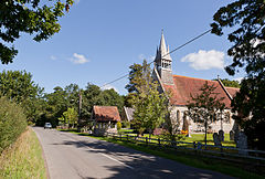
Colbury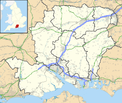
 Colbury
Colbury shown within HampshireOS grid reference SU348108 Parish Ashurst and Colbury District New Forest Shire county Hampshire Region South East Country England Sovereign state United Kingdom Post town SOUTHAMPTON Postcode district SO40 Dialling code 023 Police Hampshire Fire Hampshire Ambulance South Central EU Parliament South East England UK Parliament New Forest East List of places: UK • England • Hampshire Colbury is a small village in the New Forest National Park, in Hampshire, England. The village lies along Deerleap Lane,[1] near the modern village of Ashurst.
History
The name Colbury is derived from Middle English for "Cola's manor",[2] and near Colbury is an estate called Langley which was held by "Cola the Hunter" in the Domesday Book of 1086.[3] The manor of Colbury was given to the Abbot of Beaulieu by Robert de Punchardon sometime in the 13th century.[1] A grant of free warren in the manor was made in 1359–60 to the Abbot and convent of Beaulieu.[1] Successive abbots remained in possession of the manor until the dissolution of the abbey in April 1538, when it passed to the Crown.[1] It was purchased in 1544 by John Mill and his son John. The elder John died in 1551 and the younger John was succeeded by his son Lewknor.[1] He died in November 1587, and his son Lewknor died in the following month, leaving John his brother and heir.[1] John was created a baronet in 1619, and the manor descended with the Mill Baronets until the death of the last baronet in 1835.[1]
The site of the Colbury Manor House is about a mile to the northeast of Colbury village, close to the village of Eling.[4] The house which is now there is modern, and no trace of ancient buildings survive.[4]
Colbury was for centuries a tithing in Eling parish. Its population in 1870 was 341 people.[5] The church in Colbury, called Christ Church, was built in 1870 by Benjamin Ferrey.[6]
The civil parish of Colbury was one of the parishes created out of the ancient parish of Eling in 1894.[1] Colbury parish was abolished in 1934 when 4722 acres were transferred to the parish of Denny Lodge and 750 acres were transferred to Totton and Eling.[7] The modern parish of Ashurst and Colbury was created in 1985, but administers a much small area than the old Colbury parish.
References
- ^ a b c d e f g h Victoria County History of Hampshire: Eling
- ^ Colbury, Old Hampshire Gazetteer
- ^ Domesday Map - Langley
- ^ a b Hampshire Treasures Volume 5 (New Forest) Page 311
- ^ John Marius Wilson, (1870-72) Imperial Gazetteer of England and Wales, page 24
- ^ Hampshire Treasures Volume 5 (New Forest) Page 312
- ^ Relationships / unit history of COLBURY, www.visionofbritain.org.uk
External links
Towns, villages and hamlets in the New Forest District of Hampshire, England 
Allum Green | Applemore | Ashlett | Ashley | Ashurst | Bartley | Barton on Sea | Bashley | Beaulieu | Bisterne | Blashford | Blissford | Bolderwood | Boldre | Bramshaw | Bransgore | Breamore | Brockenhurst | Brook | Brookheath | Bucklers Hard | Burgate | Burley | Bull Hill | Cadnam | Calshot | Colbury | Copythorne | Crow | Damerham | Denny Lodge | Dibden | Dibden Purlieu | Downton | East Boldre | East End | East Hill | East Martin | East Mills | Emery Down | Ellingham | Everton | Exbury | Fawley | Fordingbridge | Fritham | Frogham | Furze Hill | Godshill | Gorley Lynch | Hale | Hale Park | Hale Purlieu | Hangersley | Harbridge | Hightown | Highwood | Hordle | Hungerford | Hyde | Hythe | Ibsley | Keyhaven | Lepe | Linbrook | Linford | Linwood | Lopshill | Lower Daggons | Lymington | Lyndhurst | Marchwood | Martin | Milford on Sea | Minstead | Mockbeggar | Netley Marsh | New Milton | Norley Wood | North Gorley | Ossemsley | Pennington | Picket Hill | Picket Post | Pilley | Portmore | Poulner | Ringwood | Rockbourne | Rockford | Sandford | Sandleheath | Shobley | Sopley | South Baddesley | South Gorley | Stuckton | Sway | Tinkers Cross | Tiptoe | Totton and Eling | Walhampton | Whitsbury | Whitsbury Common | Whitsbury Cross | Woodgreen | Woodlands
Categories:- New Forest
- Villages in Hampshire


Wikimedia Foundation. 2010.