- North Gorley
-
Coordinates: 50°54′08″N 1°46′24″W / 50.9023°N 1.7732°W
North Gorley 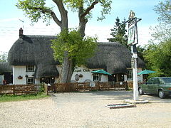
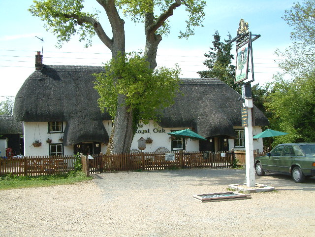
The Royal Oak, North Gorley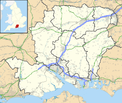
 North Gorley
North Gorley shown within HampshireOS grid reference SU160114 Parish Hyde District New Forest Shire county Hampshire Region South East Country England Sovereign state United Kingdom Post town Fordingbridge Postcode district SP6 Dialling code 01425 Police Hampshire Fire Hampshire Ambulance South Central EU Parliament South East England UK Parliament New Forest West List of places: UK • England • Hampshire North Gorley is a hamlet in the New Forest National Park of Hampshire, England. Its nearest town is Fordingbridge, which lies approximately 2 miles (3.2 km) north of the hamlet.
Contents
Location
The hamlet of North Gorley sits on the western boundary of the New Forest National Park, about 0.5 miles (0.80 km) north of South Gorley. The River Avon lies just to the west. The hamlet has one inn, The Royal Oak, which claims to be a former Royal hunting lodge.[1] There is also a restaurant known as Little Mere, which also operates as tea rooms in the summer months.[2]
History
The name Gorley means "triangular wood/clearing".[3] In 1086 Osbern the Falconer held the manor of Gorley from the King.[4] Two manors of "North Gorley" existed in the 16th century.[4] One was in the possession of John Bulkeley, which apparently passed to the Keilways of Rockbourne before 1576.[4] It was purchased by Sir John Cooper in 1608, and evidently merged in Rockbourne.[4] The other manor was acquired by the Abbot and convent of Beaulieu from Margery Rivers, John Rivers and others, and was probably granted, after the Dissolution, with Freren Court to Robert White, to whom it belonged in 1564, from which date it followed the descent of Rockford, being merged in that manor after 1634–5.[4]
North Gorley was, unlike South Gorley, in the parish of Fordingbridge.[4] In 1855 it was incorporated in the new ecclesiastical parish of Hyde,[4] and it is now part of the civil parish of Hyde.
Gorley Hill
Main article: Gorley HillTo the east of North Gorley on Gorley Common was the site of an Iron Age promontory hillfort called Gorley Hill. Much of the site was destroyed in the 1950s and 60s when the Common's new owners carried out large-scale gravel extraction works.[5]
Notes
External links
 Media related to North Gorley at Wikimedia Commons
Towns, villages and hamlets in the New Forest District of Hampshire, England 
Allum Green | Applemore | Ashlett | Ashley | Ashurst | Bartley | Barton on Sea | Bashley | Beaulieu | Bisterne | Blashford | Blissford | Bolderwood | Boldre | Bramshaw | Bransgore | Breamore | Brockenhurst | Brook | Brookheath | Bucklers Hard | Burgate | Burley | Bull Hill | Cadnam | Calshot | Colbury | Copythorne | Crow | Damerham | Denny Lodge | Dibden | Dibden Purlieu | Downton | East Boldre | East End | East Hill | East Martin | East Mills | Emery Down | Ellingham | Everton | Exbury | Fawley | Fordingbridge | Fritham | Frogham | Furze Hill | Godshill | Gorley Lynch | Hale | Hale Park | Hale Purlieu | Hangersley | Harbridge | Hightown | Highwood | Hordle | Hungerford | Hyde | Hythe | Ibsley | Keyhaven | Lepe | Linbrook | Linford | Linwood | Lopshill | Lower Daggons | Lymington | Lyndhurst | Marchwood | Martin | Milford on Sea | Minstead | Mockbeggar | Netley Marsh | New Milton | Norley Wood | North Gorley | Ossemsley | Pennington | Picket Hill | Picket Post | Pilley | Portmore | Poulner | Ringwood | Rockbourne | Rockford | Sandford | Sandleheath | Shobley | Sopley | South Baddesley | South Gorley | Stuckton | Sway | Tinkers Cross | Tiptoe | Totton and Eling | Walhampton | Whitsbury | Whitsbury Common | Whitsbury Cross | Woodgreen | Woodlands
Categories:- New Forest
- Hamlets in Hampshire

Wikimedia Foundation. 2010.