- Ossemsley
-
Coordinates: 50°46′45″N 1°40′09″W / 50.7792°N 1.6693°W
Ossemsley 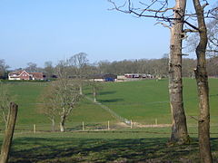
Ossemsley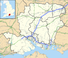
 Ossemsley
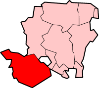
Ossemsley shown within HampshireOS grid reference SZ234978 Parish New Milton District New Forest Shire county Hampshire Region South East Country England Sovereign state United Kingdom Post town NEW MILTON Postcode district BH25 5 Dialling code 01425 Police Hampshire Fire Hampshire Ambulance South Central EU Parliament South East England UK Parliament New Forest West List of places: UK • England • Hampshire Ossemsley is an extended hamlet in the New Forest National Park of Hampshire, England. Its nearest town is New Milton, which lies approximately 1.7 miles (2.4 km) to the south-east.
The name Ossemsley probably means "Osmund's wood/clearing".[1] An estate called "Oselei" appears twice in the Domesday Book, but it is listed with places in the Boldre area, so it is thought unlikely to refer to Ossemsley.[1][2] In 1670 Thomas Stevens is known to have been in possession of "Osmondsley".[3]
Ossemsley has never developed into a village, and today it is a scatter of houses in a mix of farmland and woodland. The most notable building is Ossemsley Manor House, although the current building only dates from 1908.[4] Ossemsley Manor was one the houses in which Siegfried Sassoon's wife, Hester Gatty, spent her childhood.[5] Sassoon himself is known to have visited Ossemsley Manor in the 1930s.[6] In the lead up to the D-Day invasion of 1944, the batallion of the 2nd Glosters were stationed (in tents) at Ossemsley manor.[7]
References
- ^ a b A. T. Lloyd, J. E. S. Brooks, (1996), The History of New Milton and its Surrounding Area, Centenary Edition, page 14
- ^ H. C. Darby, Eila M. J. Campbell, (2008), The Domesday Geography of South-East England, page 327. Cambridge University Press
- ^ A. T. Lloyd, J. E. S. Brooks, (1996), The History of New Milton and its Surrounding Area, Centenary Edition, page 28
- ^ Ossemsley Manor House, English Heritage
- ^ Max Egremont, (2006), Siegfried Sassoon, page 384. Pan Macmillan
- ^ Max Egremont, (2006), Siegfried Sassoon, page 385. Pan Macmillan
- ^ Andrew Holborn, (2010), 56th Infantry Brigade and D-Day: An Independent Infantry Brigade and the Campaign in North West Europe 1944-1945., Page 57. Continuum International
Towns, villages and hamlets in the New Forest District of Hampshire, England 
Allum Green | Applemore | Ashlett | Ashley | Ashurst | Bartley | Barton on Sea | Bashley | Beaulieu | Bisterne | Blashford | Blissford | Bolderwood | Boldre | Bramshaw | Bransgore | Breamore | Brockenhurst | Brook | Brookheath | Bucklers Hard | Burgate | Burley | Bull Hill | Cadnam | Calshot | Colbury | Copythorne | Crow | Damerham | Denny Lodge | Dibden | Dibden Purlieu | Downton | East Boldre | East End | East Hill | East Martin | East Mills | Emery Down | Ellingham | Everton | Exbury | Fawley | Fordingbridge | Fritham | Frogham | Furze Hill | Godshill | Gorley Lynch | Hale | Hale Park | Hale Purlieu | Hangersley | Harbridge | Hightown | Highwood | Hordle | Hungerford | Hyde | Hythe | Ibsley | Keyhaven | Lepe | Linbrook | Linford | Linwood | Lopshill | Lower Daggons | Lymington | Lyndhurst | Marchwood | Martin | Milford on Sea | Minstead | Mockbeggar | Netley Marsh | New Milton | Norley Wood | North Gorley | Ossemsley | Pennington | Picket Hill | Picket Post | Pilley | Portmore | Poulner | Ringwood | Rockbourne | Rockford | Sandford | Sandleheath | Shobley | Sopley | South Baddesley | South Gorley | Stuckton | Sway | Tinkers Cross | Tiptoe | Totton and Eling | Walhampton | Whitsbury | Whitsbury Common | Whitsbury Cross | Woodgreen | Woodlands
Categories:- Hampshire geography stubs
- New Forest
- Hamlets in Hampshire


Wikimedia Foundation. 2010.