- County of Tambo, Victoria
-
Tambo
Victoria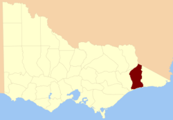
Location in VictoriaEstablished: 24 February 1871 Area: 5091 km² Lands administrative divisions around Tambo Benambra Benambra Wallace (NSW) Dargo Tambo Croajingolong Bass Strait Bass Strait Bass Strait The County of Tambo is one of the 37 counties of Victoria which are part of the cadastral divisions of Australia, used for land titles. It is located in eastern Gippsland, between the Tambo River in the west, and the Snowy River in the east. It includes Lakes Entrance. Before the 1860s the area was part of the former counties of Combermere and Abinger.
Parishes
Parishes include:
- Berrmarr, Victoria
- Bete Bolong North, Victoria
- Bete Bolong South, Victoria
- Bindi, Victoria
- Buchan, Victoria
- Chilpin, Victoria
- Colquhoun, Victoria
- Colquhoun East, Victoria
- Colquhoun North, Victoria
- Detarka, Victoria
- Ensay, Victoria
- Eucambene, Victoria
- Eumana, Victoria
- Forest Hill, Victoria
- Gelantipy East, Victoria
- Gelantipy West, Victoria
- Gillingal, Victoria
- Glenmore, Victoria
- Ingeegoobee, Victoria
- Kaerwut, Victoria
- Karawah, Victoria
- Maneroo, Victoria
- Marroo, Victoria
- Mellick-Munjie, Victoria
- Menaak, Victoria
- Murrindal East, Victoria
- Murrindal West, Victoria
- Nappa, Victoria
- Newmerella, Victoria
- Ninnie, Victoria
- Nowa Nowa, Victoria
- Nowa Nowa South, Victoria
- Noyong, Victoria
- Numbie-Munjie, Victoria
- Tildesley East, Victoria
- Tildesley West, Victoria
- Timbarra, Victoria
- Tongio-Munjie East, Victoria
- Toonginbooka, Victoria
- Waygara, Victoria
- Windarra, Victoria
- Woongulmerang East, Victoria
- Woongulmerang West, Victoria
References
- Vicnames, place name details
- Research aids, Victoria 1910
- Cadastral map showing county and parish boundaries, categories of land holdings and reserves. 1880s, National Library of Australia
Counties of Victoria Anglesey • Benambra • Bendigo • Bogong • Borung • Bourke • Buln Buln • Croajingolong • Dalhousie • Dargo • Delatite • Dundas • Evelyn • Follett • Gladstone • Grant • Grenville • Gunbower • Hampden • Heytesbury • Kara Kara • Karkarooc • Lowan • Millewa • Moira • Mornington • Normanby • Polwarth • Ripon • Rodney • Talbot • Tambo • Tanjil • Tatchera • Villiers • Weeah • Wonnangatta
Categories:- Counties of Victoria (Australia)

Wikimedia Foundation. 2010.