- County of Millewa
-
Millewa
Victoria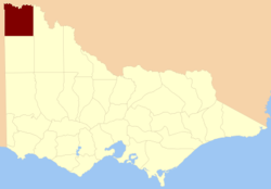
Location in VictoriaEstablished: 24 February 1871 Area: 9,251 km² Lands administrative divisions around Millewa Hamley (SA) Tara (NSW) Wentworth (NSW) Alfred (SA) Millewa Karkarooc Chandos (SA) Weeah Karkarooc The County of Millewa is one of the 37 counties of Victoria which are part of the cadastral divisions of Australia, used for land titles. It is located to the south of the Murray River, at the north-western corner of Victoria, with the South Australian border to the west. This border was originally intended to be at the 141st meridian of longitude, but because of the South Australia-Victoria border dispute it is several miles to the west of it. The southern boundary of the county is at 35°S, and the eastern at 142°E. The name is also used for the region.
Parishes
Parishes include:
- Mildura shared with Karkarooc
- Mullroo
- Toupnein
- Warina
- Woolwoola
- Yelta
References
- Vicnames, place name details
- Research aids, Victoria 1910
- Map of the counties of Millewa, Karkarooc, Tatchera and Weeah showing colony and parish boundaries, main roads, telegraph lines and railways. 1886. National Library of Australia
Counties of Victoria Anglesey • Benambra • Bendigo • Bogong • Borung • Bourke • Buln Buln • Croajingolong • Dalhousie • Dargo • Delatite • Dundas • Evelyn • Follett • Gladstone • Grant • Grenville • Gunbower • Hampden • Heytesbury • Kara Kara • Karkarooc • Lowan • Millewa • Moira • Mornington • Normanby • Polwarth • Ripon • Rodney • Talbot • Tambo • Tanjil • Tatchera • Villiers • Weeah • Wonnangatta
Categories:- Counties of Victoria (Australia)

Wikimedia Foundation. 2010.