- County of Grant, Victoria
-
Grant
Victoria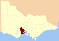
Location in VictoriaLands administrative divisions around Grant Ripon Talbot Bourke Grenville Grant Bourke Polwarth Southern Ocean Port Phillip Bay The County of Grant is one of the 37 counties of Victoria which are part of the cadastral divisions of Australia, used for land titles. It is located to the west of Melbourne, on the west side of Port Phillip Bay and includes Geelong. Ballarat is on its north-western edge. It is bounded in the west by the Yarrowee River, on the north by the Great Dividing Range and on the east by the Werribee River.
Parishes
Parishes within the county:
- Anakie, Victoria
- Ballark, Victoria
- Ballarat, Victoria (also in the counties of Grant, Grenville, Ripon & Talbot)
- Balliang, Victoria
- Bamganie, Victoria
- Barrarbool, Victoria
- Bellarine, Victoria
- Beremboke, Victoria
- Borhoneyghurk, Victoria
- Bulban, Victoria
- Bungal, Victoria
- Bungaree, Victoria (also in the counties of Grant, Grenville & Talbot)
- Bungeeltap, Victoria
- Buninyong, Victoria
- Burtwarrah, Victoria
- Cargerie, Victoria
- Carrah, Victoria
- Carrung-e-murnong, Victoria
- Clarendon, Victoria
- Cocoroc, Victoria
- Conewarre, Victoria
- Coolebarghurk, Victoria
- Corio, Victoria
- Darriwil, Victoria
- Dean, Victoria (also in the county of Talbot)
- Duneed, Victoria
- Durdidwarrah, Victoria
- Gherang Gherang, Victoria
- Gherineghap, Victoria
- Gnarwarre, Victoria
- Gorong, Victoria
- Gorrockburkghap, Victoria
- Jan Juc, Victoria
- Kerrit Bareet, Victoria
- Korweinguboora, Victoria
- Lake Lake Wollard, Victoria
- Lal Lal, Victoria
- Lara, Victoria
- Mambourin, Victoria
- Meredith, Victoria
- Modewarre, Victoria
- Moolap, Victoria
- Mooradoranook, Victoria
- Moorarbool West, Victoria
- Moorpanyal, Victoria
- Moranghurk, Victoria
- Moreep, Victoria
- Mouyong, Victoria
- Murgheboluc, Victoria
- Murtcaim, Victoria
- Narmbool, Victoria
- Paraparap, Victoria
- Parwan, Victoria
- Paywit, Victoria
- Puebla, Victoria
- Tutegong, Victoria
- Wabdallah, Victoria
- Warrenheip, Victoria
- Werribee, Victoria
- Woornyalook, Victoria
- Wormbete, Victoria
- Wurdi-Youang, Victoria
- Yaloak, Victoria
- Yowang, Victoria
References
- Vicnames, place name details
- Research aids, Victoria 1910
- Map of the county of Grant showing colony and county boundaries, 1886. National Library of Australia
Coordinates: 37°50′S 144°10′E / 37.833°S 144.167°E
Counties of Victoria Anglesey • Benambra • Bendigo • Bogong • Borung • Bourke • Buln Buln • Croajingolong • Dalhousie • Dargo • Delatite • Dundas • Evelyn • Follett • Gladstone • Grant • Grenville • Gunbower • Hampden • Heytesbury • Kara Kara • Karkarooc • Lowan • Millewa • Moira • Mornington • Normanby • Polwarth • Ripon • Rodney • Talbot • Tambo • Tanjil • Tatchera • Villiers • Weeah • Wonnangatta
Categories:- Counties of Victoria (Australia)
- Victoria (Australia) geography stubs

Wikimedia Foundation. 2010.