Machaire Rabhartaigh

Machaire Rabhartaigh
—  Village  —
A view of Machaire Rabhartaigh strand, October 2011
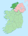
Machaire Rabhartaigh is located in Ireland
Machaire Rabhartaigh
Location in Ireland
Coordinates: 55°03′03″N 8°14′08″W / 55.050941°N 8.235626°W / 55.050941; -8.235626Coordinates: 55°03′03″N 8°14′08″W / 55.050941°N 8.235626°W / 55.050941; -8.235626
Country Ireland
Province Ulster
County County Donegal
Government
 - Dáil Éireann Donegal South West
Area code(s) 074, +000 353 74
Irish Grid Reference B847228

Machaire Rabhartaigh (formerly anglicized as Magheraroarty), meaning "plain of the high tide",[1] is a Gaeltacht village and townland on the north-west coast of County Donegal, Ireland. It is in the parish of Cloughaneely and its main access road is the R257.

It has been home to a Gael Linn Irish Language Summer School since 1981 which runs three[2] courses for teenagers aged 12–18 every summer and has an intake of about 200[3] students per course.

The village has a port suited for fishing vessels. It is the main ferry port for Tory Island.

It attracts many tourists during the summer and watersports enthusiasts visit the area to windsurf/surf/kitesurf and to go kayaking in the bay. A natural reef exists to the left of the pier which provides excellent surf throughout the year. Anemities include Coll's Bar, a café and Scoil Naomh Dubhthach Mhachaire Rabhartaigh, an Irish-speaking primary school.

References


Wikimedia Foundation. 2010.

Игры ⚽ Поможем сделать НИР

Look at other dictionaries:

  • Machaire Uí Rabhartaigh — Magheroarty oder Machaire Uí Rabhartaigh ist eine kleine irischsprachige Gemeinde an der Nordwestküste des County Donegal, Irland. Von Magheroarty gibt es eine ganzjährige Fährverbindung nach Tory Island. Der Ort verfügt über einen großen… …   Deutsch Wikipedia

  • Magheroarty — Infobox Irish Place name = Magheroarty gaeilge = Machaire Uí Rabhartaigh map pin coords = left: 52px; top: 32px north coord = 55.050941 | west coord = 8.235626 | irish grid = B847228 area = | elevation = province = Ulster county = County Donegal… …   Wikipedia

  • Cloughaneely — A sign indicating the beginning of Cloughaneely. Cloughaneely (official name: Cloch Cheann Fhaola)[1] is a district in the west of County Donegal, part of the Province of Ulster in Ireland. This is a mainly coastal area centred on the town of… …   Wikipedia

  • Махаря-Раурти — Деревня Ирландии Махаря Раурти англ. Magheraroarty, ирл. Machaire Rabhartaigh Страна …   Википедия

  • The Groovin' Reels — are an Irish Traditional band from various areas of Ireland, who believe in modernization of Irish Folk music. The first met at Machaire Rabhartaigh, Donegal on a Summer Gaeltacht course. They play a range of music, written themselves and by… …   Wikipedia

  • Île de Toraigh — Toraigh Les falaises de l île de Toraigh Géographie Pays …   Wikipédia en Français

  • Magheroarty — oder Machaire Uí Rabhartaigh ist eine kleine irischsprachige Gemeinde an der Nordwestküste des County Donegal, Irland. Von Magheroarty gibt es eine ganzjährige Fährverbindung nach Tory Island. Der Ort verfügt über einen großen Sandstrand und ist… …   Deutsch Wikipedia

Share the article and excerpts

Direct link
Do a right-click on the link above
and select “Copy Link”