- National Register of Historic Places listings in Caribou County, Idaho
-
 Location of Caribou County in Idaho
This is a list of the National Register of Historic Places listings in Caribou County, Idaho.
This is intended to be a complete list of the properties and districts on the National Register of Historic Places in Caribou County, Idaho, United States. Latitude and longitude coordinates are provided for many National Register properties and districts; these locations may be seen together in a Google map.[1]
There are 8 properties and districts listed on the National Register in the county. More may be added; properties and districts nationwide are added to the Register weekly.[2]
-
- This National Park Service list is complete through NPS recent listings posted November 10, 2011.[3]
Current listings
[4] Landmark name [5] Image Date listed Location City or town Summary 1 Caribou County Courthouse 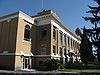
September 22, 1987 159 S. Main
42°39′21″N 111°36′08″W / 42.655833°N 111.602222°WSoda Springs 2 Chesterfield Historic District 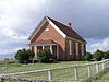
December 4, 1980 Town of Chesterfield
42°52′01″N 111°54′22″W / 42.866944°N 111.906111°WChesterfield 3 Enders Hotel May 14, 1993 76 S. Main St.
42°39′27″N 111°36′12″W / 42.6575°N 111.603333°WSoda Springs 4 Grace Pegram Truss Railroad Bridge July 25, 1997 Over the Bear River 0.5 miles north-northwest of the junction of State Highway 34 and Turner Rd.
42°35′06″N 111°44′05″W / 42.585°N 111.734722°WGrace 5 William Hopkins House January 8, 1979 351 E. Hooper Ave.
42°39′33″N 111°35′33″W / 42.659167°N 111.5925°WSoda Springs 6 Lander Road April 24, 1975 Northeast of Soda Springs in the Caribou National Forest, south of State Highway 34
42°52′55″N 111°11′07″W / 42.881944°N 111.185278°WSoda Springs 7 Edgar Walter Largilliere, Sr. House December 23, 1991 30 W. 2nd, S. St.
42°39′18″N 111°36′13″W / 42.655°N 111.603611°WSoda Springs 8 Soda Springs City Hall May 14, 1993 109 S. Main St.
42°39′24″N 111°36′08″W / 42.656667°N 111.602222°WSoda Springs See also
References
- ^ The latitude and longitude information provided in this table was derived originally from the National Register Information System, which has been found to be fairly accurate for about 99% of listings. For about 1% of NRIS original coordinates, experience has shown that one or both coordinates are typos or otherwise extremely far off; some corrections may have been made. A more subtle problem causes many locations to be off by up to 150 yards, depending on location in the country: most NRIS coordinates were derived from tracing out latitude and longitudes off of USGS topographical quadrant maps created under the North American Datum of 1927, which differs from the current, highly accurate WGS84 GPS system used by Google maps. Chicago is about right, but NRIS longitudes in Washington are higher by about 4.5 seconds, and are lower by about 2.0 seconds in Maine. Latitudes differ by about 1.0 second in Florida. Some locations in this table may have been corrected to current GPS standards.
- ^ "National Register of Historic Places: Weekly List Actions". National Park Service. http://www.cr.nps.gov/nr/nrlist.htm. Retrieved March 29, 2009.
- ^ "National Register of Historic Places: Weekly List Actions". National Park Service, United States Department of the Interior. Retrieved on November 10, 2011.
- ^ Numbers represent an ordering by significant words. Various colorings, defined here, differentiate National Historic Landmark sites and National Register of Historic Places Districts from other NRHP buildings, structures, sites or objects.
- ^ "National Register Information System". National Register of Historic Places. National Park Service. . http://nrhp.focus.nps.gov/natreg/docs/All_Data.html.
Properties on the National Register of Historic Places in Idaho  Ada • Adams • Bannock • Bear Lake • Benewah • Bingham • Blaine • Boise • Bonner • Bonneville • Boundary • Butte • Camas • Canyon • Caribou • Cassia • Clark • Clearwater • Custer • Elmore • Franklin • Fremont • Gem • Gooding • Idaho • Jefferson • Jerome • Kootenai • Latah • Lemhi • Lewis • Lincoln • Madison • Minidoka • Nez Perce • Oneida • Owyhee • Payette • Power • Shoshone • Teton • Twin Falls • Valley • Washington
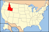
U.S. National Register of Historic Places Topics Lists by states Alabama • Alaska • Arizona • Arkansas • California • Colorado • Connecticut • Delaware • Florida • Georgia • Hawaii • Idaho • Illinois • Indiana • Iowa • Kansas • Kentucky • Louisiana • Maine • Maryland • Massachusetts • Michigan • Minnesota • Mississippi • Missouri • Montana • Nebraska • Nevada • New Hampshire • New Jersey • New Mexico • New York • North Carolina • North Dakota • Ohio • Oklahoma • Oregon • Pennsylvania • Rhode Island • South Carolina • South Dakota • Tennessee • Texas • Utah • Vermont • Virginia • Washington • West Virginia • Wisconsin • WyomingLists by territories Lists by associated states Other Municipalities and communities of Caribou County, Idaho Cities 
Unincorporated
communitiesIndian reservation Ghost town Footnotes ‡ This populated place also extends into Wyoming, ‡‡ This populated place also has portions in an adjacent county or counties
Categories:- National Register of Historic Places in Idaho by county
- Caribou County, Idaho
-


Wikimedia Foundation. 2010.