- National Register of Historic Places listings in Power County, Idaho
-
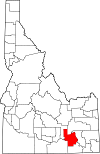 Location of Power County in Idaho
This is a list of the National Register of Historic Places listings in Power County, Idaho.
This is intended to be a complete list of the properties and districts on the National Register of Historic Places in Power County, Idaho, United States. Latitude and longitude coordinates are provided for many National Register properties and districts; these locations may be seen together in a Google map.[1]
There are 12 properties and districts listed on the National Register in the county. More may be added; properties and districts nationwide are added to the Register weekly.[2]
-
- This National Park Service list is complete through NPS recent listings posted November 10, 2011.[3]
Current listings
[4] Landmark name [5] Image Date listed Location City or town Summary 1 American Falls Archeological District July 1, 1999 Address Restricted[6] American Falls 2 American Falls East Shore Power Plants 
October 29, 1976 State Highway 39
42°46′34″N 112°52′27″W / 42.776111°N 112.874167°WAmerican Falls 3 American Falls Reservoir Flooded Townsite January 28, 2002 American Falls Reservoir
42°47′31″N 112°51′55″W / 42.791944°N 112.865278°WAmerican Falls 4 Bethany Deaconess Hospital April 27, 1995 500 Pocatello Highway Ave.
42°47′02″N 112°50′53″W / 42.783889°N 112.848056°WAmerican Falls 5 William Davie House April 2, 2008 703 Hutchinson Ave.
42°46′53″N 112°51′18″W / 42.78137°N 112.85489°WAmerican Falls 6 Oneida Milling and Elevator Company Grain Elevator July 16, 1993 Offshore in American Falls Reservoir
42°47′05″N 112°52′04″W / 42.784722°N 112.867778°WAmerican Falls 7 Oregon Trail Historic District March 20, 1973 Southwest of American Falls along U.S. Route 30N, and west of American Falls
42°39′16″N 113°02′38″W / 42.654444°N 113.043889°WAmerican Falls "West of American Falls" represents a boundary increase 8 Power County Courthouse 
September 22, 1987 Bannock Ave.
42°46′59″N 112°50′55″W / 42.783056°N 112.848611°WAmerican Falls 9 Register Rock July 24, 1978 West of American Falls on U.S. Route 30
42°39′10″N 113°00′58″W / 42.652778°N 113.016111°WAmerican Falls 10 St. John's Episcopal Church February 7, 2007 328 Roosevelt St.
42°46′56″N 112°51′04″W / 42.782222°N 112.851111°WAmerican Falls 11 Walter Sparks House February 7, 2007 408 Roosevelt St.
42°46′55″N 112°50′58″W / 42.781944°N 112.849444°WAmerican Falls 12 Richard and Winnie Warwas House August 31, 2006 275 Polk St.
42°46′53″N 112°51′11″W / 42.781389°N 112.853056°WAmerican Falls See also
References
- ^ The latitude and longitude information provided in this table was derived originally from the National Register Information System, which has been found to be fairly accurate for about 99% of listings. For about 1% of NRIS original coordinates, experience has shown that one or both coordinates are typos or otherwise extremely far off; some corrections may have been made. A more subtle problem causes many locations to be off by up to 150 yards, depending on location in the country: most NRIS coordinates were derived from tracing out latitude and longitudes off of USGS topographical quadrant maps created under the North American Datum of 1927, which differs from the current, highly accurate WGS84 GPS system used by Google maps. Chicago is about right, but NRIS longitudes in Washington are higher by about 4.5 seconds, and are lower by about 2.0 seconds in Maine. Latitudes differ by about 1.0 second in Florida. Some locations in this table may have been corrected to current GPS standards.
- ^ "National Register of Historic Places: Weekly List Actions". National Park Service. http://www.cr.nps.gov/nr/nrlist.htm. Retrieved March 29, 2009.
- ^ "National Register of Historic Places: Weekly List Actions". National Park Service, United States Department of the Interior. Retrieved on November 10, 2011.
- ^ Numbers represent an ordering by significant words. Various colorings, defined here, differentiate National Historic Landmark sites and National Register of Historic Places Districts from other NRHP buildings, structures, sites or objects.
- ^ "National Register Information System". National Register of Historic Places. National Park Service. . http://nrhp.focus.nps.gov/natreg/docs/All_Data.html.
- ^ Some listings on the NRHP are highly sensitive sites and may be subject to looting or vandalism. The NRHP lists this site as "Address Restricted."
Properties on the National Register of Historic Places in Idaho  Ada • Adams • Bannock • Bear Lake • Benewah • Bingham • Blaine • Boise • Bonner • Bonneville • Boundary • Butte • Camas • Canyon • Caribou • Cassia • Clark • Clearwater • Custer • Elmore • Franklin • Fremont • Gem • Gooding • Idaho • Jefferson • Jerome • Kootenai • Latah • Lemhi • Lewis • Lincoln • Madison • Minidoka • Nez Perce • Oneida • Owyhee • Payette • Power • Shoshone • Teton • Twin Falls • Valley • Washington
U.S. National Register of Historic Places Topics Lists by states Alabama • Alaska • Arizona • Arkansas • California • Colorado • Connecticut • Delaware • Florida • Georgia • Hawaii • Idaho • Illinois • Indiana • Iowa • Kansas • Kentucky • Louisiana • Maine • Maryland • Massachusetts • Michigan • Minnesota • Mississippi • Missouri • Montana • Nebraska • Nevada • New Hampshire • New Jersey • New Mexico • New York • North Carolina • North Dakota • Ohio • Oklahoma • Oregon • Pennsylvania • Rhode Island • South Carolina • South Dakota • Tennessee • Texas • Utah • Vermont • Virginia • Washington • West Virginia • Wisconsin • WyomingLists by territories Lists by associated states Other Municipalities and communities of Power County, Idaho Cities 
CDP Unincorporated
communitiesArbon | Neeley | Pauline | Roy
Indian reservation Footnotes ‡This populated place also has portions in an adjacent county or counties
Categories:- National Register of Historic Places in Idaho by county
- Power County, Idaho
-


Wikimedia Foundation. 2010.