- National Register of Historic Places listings in Hampton, Virginia
-
This list includes properties and districts listed on the National Register of Historic Places in the independent city of Hampton, Virginia. Click the "Map of all coordinates" link to the right to view a Google map of all properties and districts with latitude and longitude coordinates in the table below.[1]
-
- This National Park Service list is complete through NPS recent listings posted November 10, 2011.[2]
[3] Landmark name[4] Image Date listed Location City or Town Summary 1 Aberdeen Gardens May 26, 1994 Roughly bounded by Langston and Mary Peake Blvds., and Russell, Davis, Lewis, Weaver and Walker Rds.
37°2′0″N 76°24′21″W / 37.033333°N 76.40583°WHampton 2 Buckroe Beach Carousel October 27, 1992 602 Settlers Landing Rd.
37°1′26″N 76°20′38″W / 37.02389°N 76.34389°WHampton 3 Chamberlin Hotel March 21, 2007 #2 Fenwick Rd., Fort Monroe
37°0′3″N 76°18′48″W / 37.00083°N 76.31333°WHampton 4 Chapel of the Centurion March 28, 2011 134 Bernard Rd., Fort Monroe
37°0′10″N 76°18′27″W / 37.00278°N 76.3075°WHampton Oldest continually used wooden military structure for religious services in the United States; built in 1858[5] 5 Chesterville Plantation Site August 14, 1973 Address Restricted Hampton 6 Reuben Clark House August 16, 1984 125 S. Willard Ave.
37°0′52″N 76°19′12″W / 37.01444°N 76.32°WHampton 7 Eight-Foot High Speed Tunnel 
October 3, 1985 Langley Research Center
37°4′56″N 76°20′29″W / 37.08222°N 76.34139°WHampton 8 Fort Monroe 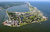
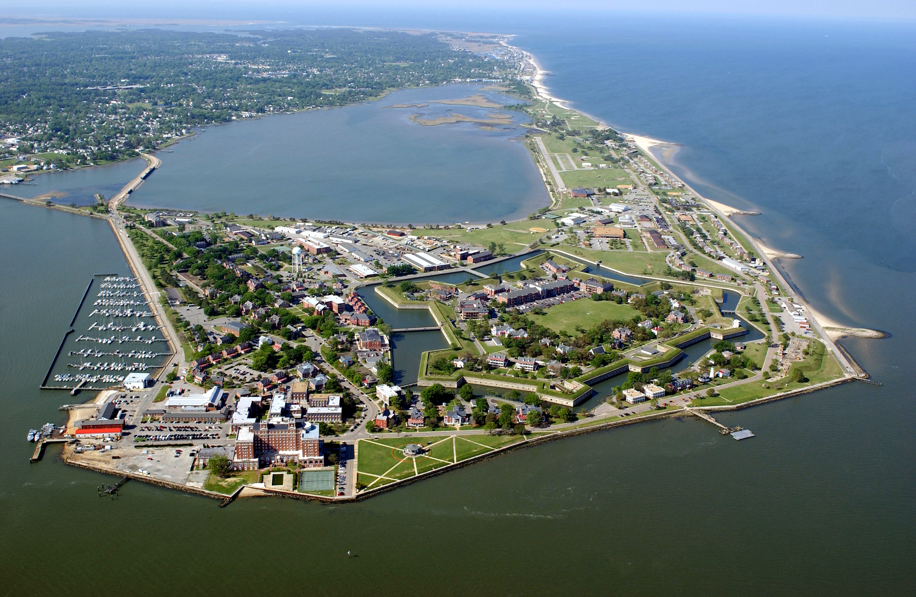
October 15, 1966 Old Point Comfort
37°0′45″N 76°18′27″W / 37.0125°N 76.3075°WHampton 9 Fort Wool 
November 25, 1969 Island between Willoughby Spit and Old Point Comfort
36°59′12″N 76°18′4″W / 36.98667°N 76.30111°WHampton 10 Full Scale Tunnel 
October 3, 1985 Langley Research Center
37°4′58″N 76°20′30″W / 37.08278°N 76.34167°WHampton 11 Hampton City Hall August 8, 2007 100 Kings Way
37°1′34″N 76°20′40″W / 37.02611°N 76.34444°WHampton 12 Hampton Downtown Historic District December 27, 2010 Roughly bounded by Franklin St., Lincoln St., Settlers Landing Rd., Eaton St.
37°1′34″N 76°20′40″W / 37.02611°N 76.34444°WHampton 13 Hampton Institute 
November 12, 1969 NW of jct. of U.S. 60 and the Hampton Roads Bridge Tunnel
37°1′13″N 76°20′9″W / 37.02028°N 76.33583°WHampton 14 Hampton National Cemetery 
February 26, 1996 Jct. of Cemetery Rd. and Marshall Ave.
37°1′11″N 76°19′48″W / 37.01972°N 76.33°WHampton 15 Herbert House February 23, 1972 E end of Marina Rd. on Hampton Creek
37°0′58″N 76°20′37″W / 37.01611°N 76.34361°WHampton 16 Little England Chapel July 8, 1982 4100 Kecoughtan Rd.
37°0′47″N 76°21′11″W / 37.01306°N 76.35306°WHampton 17 Lunar Landing Research Facility 
October 3, 1985 Langley Research Center
37°6′8″N 76°23′23″W / 37.10222°N 76.38972°WHampton 18 Old Point Comfort Lighthouse 
March 1, 1973 Fenwick Rd., SW of E gate of Fort Monroe
37°0′6″N 76°18′25″W / 37.00167°N 76.30694°WHampton 19 Phoebus Historic District December 1, 2006 Roughly bounded by VA 64, Mallory St., E. County St. and Willard Ave.
37°1′7″N 76°19′14″W / 37.01861°N 76.32056°WHampton 20 Quarters 1 March 28, 2011 151 Bernard Rd., Fort Monroe
37°0′14″N 76°18′20″W / 37.00389°N 76.30556°WHampton Headquarters of Fort Monroe from 1819 to 1907;[6] quarters used by Abraham Lincoln while planning the attack on Norfolk during the American Civil War[7] 21 Quarters 17 March 28, 2011 41A, 41B, 47A, 47B Bernard Rd., Fort Monroe
37°0′9″N 76°18′32″W / 37.0025°N 76.30889°WHampton Quarters of Robert E. Lee during the construction of Fort Monroe, 1831–1834;[8] 22 Rendezvous Docking Simulator 
October 3, 1985 Langley Research Center
37°5′8″N 76°22′41″W / 37.08556°N 76.37806°WHampton 23 Scott House August 5, 1999 232 S. Armistead Ave.
37°1′22″N 76°21′2″W / 37.02278°N 76.35056°WHampton 24 St. John's Church 
February 26, 1970 NW corner of W. Queen and Court Sts.
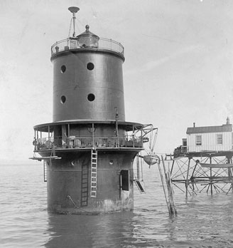
37°1′33″N 76°20′49″W / 37.02583°N 76.34694°WHampton The oldest English-speaking church in the US, est. 1610.[9] 25 Thimble Shoal Light Station 
December 2, 2002 Approx. 1.5 mi (2.4 km). E of Fort Monroe Military Reservation
37°1′2″N 76°14′24″W / 37.01722°N 76.24°WHampton 26 William H. Trusty House June 22, 1979 76 W. County St.
37°1′18″N 76°19′29″W / 37.02167°N 76.32472°WHampton 27 Variable Density Tunnel 
October 3, 1985 Langley Research Center
37°4′43″N 76°20′39″W / 37.07861°N 76.34417°WHampton 28 Victoria Boulevard Historic District October 4, 1984 Roughly bounded by Sunset Creek, Armisted and Linden Aves., and Bridge St.
37°1′9″N 76°20′53″W / 37.01917°N 76.34806°WHampton See also
- National Register of Historic Places listings in Virginia
- List of National Historic Landmarks in Virginia
References
- ^ The latitude and longitude information provided in this table was derived originally from the National Register Information System, which has been found to be fairly accurate for about 99% of listings. For about 1% of NRIS original coordinates, experience has shown that one or both coordinates are typos or otherwise extremely far off; some corrections may have been made. A more subtle problem causes many locations to be off by up to 150 yards, depending on location in the country: most NRIS coordinates were derived from tracing out latitude and longitudes off of USGS topographical quadrant maps created under the North American Datum of 1927, which differs from the current, highly accurate WGS84 GPS system used by Google maps. Chicago is about right, but NRIS longitudes in Washington are higher by about 4.5 seconds, and are lower by about 2.0 seconds in Maine. Latitudes differ by about 1.0 second in Florida. Some locations in this table may have been corrected to current GPS standards.
- ^ "National Register of Historic Places: Weekly List Actions". National Park Service, United States Department of the Interior. Retrieved on November 10, 2011.
- ^ Numbers represent an ordering by significant words. Various colorings, defined here, differentiate National Historic Landmark sites and National Register of Historic Places Districts from other NRHP buildings, structures, sites or objects.
- ^ "National Register Information System". National Register of Historic Places. National Park Service. 2008-04-24. http://nrhp.focus.nps.gov/natreg/docs/All_Data.html.
- ^ Stefansky, Krys (March 22, 2009). "Army post at peace". The Virginian-Pilot (Hampton Roads, Virginia: Landmark Media Enterprises). http://hamptonroads.com/2009/03/army-post-peace. Retrieved April 14, 2011.
- ^ "Fort Monroe History". City of Hampton, Virginia. http://www.hampton.gov/fort_monroe/history.html. Retrieved April 14, 2011.
- ^ MacAulay, David (December 7, 2009). "Fort Monroe in Hampton eyed for private sector". The Virginian-Pilot (Hampton Roads, Virginia: Landmark Media Enterprises). http://hamptonroads.com/2009/12/fort-monroe-hampton-eyed-private-sector. Retrieved April 14, 2011.
- ^ "Fort Monroe Historic Preservation Design Standards". Fort Monroe, Virginia: Fort Monroe Authority. June 18, 2010. p. 2C.19. http://www.fmauthority.com/pdf/14_2C-Management_Zones-2of2.pdf. Retrieved April 14, 2011.
- ^ "Brief History of St. John's Episcopal Church". Hampton, Virginia. http://www.stjohnshampton.org/history.shtml. Retrieved 2009-06-16.
U.S. National Register of Historic Places Topics Lists by states Alabama • Alaska • Arizona • Arkansas • California • Colorado • Connecticut • Delaware • Florida • Georgia • Hawaii • Idaho • Illinois • Indiana • Iowa • Kansas • Kentucky • Louisiana • Maine • Maryland • Massachusetts • Michigan • Minnesota • Mississippi • Missouri • Montana • Nebraska • Nevada • New Hampshire • New Jersey • New Mexico • New York • North Carolina • North Dakota • Ohio • Oklahoma • Oregon • Pennsylvania • Rhode Island • South Carolina • South Dakota • Tennessee • Texas • Utah • Vermont • Virginia • Washington • West Virginia • Wisconsin • WyomingLists by territories Lists by associated states Other Categories:- Hampton, Virginia
- National Register of Historic Places in Virginia
- Virginia-related lists
-


Wikimedia Foundation. 2010.