- National Register of Historic Places listings in Pennington County, South Dakota
-
 Location of Pennington County in South Dakota
This is a list of the National Register of Historic Places listings in Pennington County, South Dakota.
This is intended to be a complete list of the properties and districts on the National Register of Historic Places in Pennington County, South Dakota, United States. The locations of National Register properties and districts for which the latitude and longitude coordinates are included below, may be seen in a Google map.[1]
There are 55 properties and districts listed on the National Register in the county.
-
- This National Park Service list is complete through NPS recent listings posted November 10, 2011.[2]
Current listings
[3] Landmark name [4] Image Date listed Location City or town Summary 1 Archeological Site No. 39PN376 October 25, 1993 Address Restricted Custer 2 Black Hills Model Home December 15, 2004 2101 West Boulevard
44°03′54″N 103°14′07″W / 44.065°N 103.235278°WRapid City 3 Burlington and Quincy High Line Hill City to Keystone Branch 
February 5, 2003 Along the railroad right of way from 222 Railroad Ave to Keystone Depot
43°54′51″N 103°30′06″W / 43.914167°N 103.501667°WHill City 4 Lewis Byron House June 17, 1982 Cemetery Rd.
43°53′10″N 103°25′13″W / 43.886111°N 103.420278°WKeystone 5 Calumet Hotel 
January 7, 2000 Ash and B Ave.
44°04′04″N 102°26′47″W / 44.067778°N 102.446389°WWasta 6 Casper Supply Company of SD August 16, 2000 415 Main St.
44°04′50″N 103°13′26″W / 44.080556°N 103.223889°WRapid City 7 Cassidy House December 2, 1998 4121 Canyon Lake Rd.
44°03′53″N 103°17′16″W / 44.064722°N 103.287778°WRapid City 8 Church of the Immaculate Conception June 5, 1975 918 5th St.
44°04′33″N 103°13′31″W / 44.075833°N 103.225278°WRapid City 9 Civilian Conservation Corp Camp F-10 January 28, 2004 13381 Silver Mountain Rd.
43°56′56″N 103°22′53″W / 43.948889°N 103.381389°WRapid City 10 Dean Motor Company June 23, 1995 329 Main St.
44°04′49″N 103°13′21″W / 44.080278°N 103.2225°WRapid City 11 Dinosaur Park June 21, 1990 Skyline Dr. southwest of Lincoln School
44°04′40″N 103°14′42″W / 44.077778°N 103.245°WRapid City 12 Emmanuel Episcopal Church May 29, 1975 717 Quincy St.
44°04′41″N 103°13′50″W / 44.078056°N 103.230556°WRapid City 13 Fairmont Creamery Company Building February 14, 2006 201 Main St.
44°04′55″N 103°13′18″W / 44.081944°N 103.221667°WRapid City 14 Feigel House March 3, 1997 328 E. New York St.
44°05′05″N 103°12′21″W / 44.084722°N 103.205833°WRapid City 15 First Congregational Church February 23, 1984 715 Kansas City St.
44°04′45″N 103°13′47″W / 44.079167°N 103.229722°WRapid City 16 Gambrill Storage Building February 23, 1984 822 Main St.
44°04′55″N 103°13′52″W / 44.081944°N 103.231111°WRapid City 17 Gramberg Ranch December 17, 1999 14895 Lower Spring Rd.
43°54′30″N 103°05′02″W / 43.908333°N 103.083889°WHermosa 18 Harney Peak Hotel April 11, 1977 U.S. Route 16
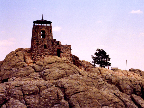
43°55′58″N 103°34′30″W / 43.932778°N 103.575°WHill City 19 Harney Peak Lookout Tower, Dam, Pumphouse and Stairway 
March 10, 1983 Northeast of Custer
43°51′57″N 103°31′55″W / 43.865833°N 103.531944°WCuster 20 Harney Peak Tin Mining Company Buildings July 21, 1977 U.S. Route 16
43°56′08″N 103°33′53″W / 43.935556°N 103.564722°WHill City 21 Zack Holmes House June 17, 1982 818 St. James St.
44°04′22″N 103°13′57″W / 44.072778°N 103.2325°WRapid City 22 House and Sawmill Johnson Siding June 17, 1982 Rimrock Highway
44°04′50″N 103°26′26″W / 44.080556°N 103.440556°WRapid City 23 Keystone School February 22, 1981 3rd St.
43°53′43″N 103°25′11″W / 43.895278°N 103.419722°WKeystone 24 Keystone Trading Company Store June 17, 1982 Highway 40
43°53′47″N 103°25′07″W / 43.896389°N 103.418611°WKeystone 25 Madison Ranch August 14, 2003 8800 Nemo Rd.
44°07′11″N 103°21′48″W / 44.119722°N 103.363333°WRapid City 26 Pap Madison Cabin February 19, 2008 Bounded by W. Main St., St. Joseph St., and West Boulevard
44°05′02″N 103°14′17″W / 44.083889°N 103.238056°WRapid City 27 C.E. McEachron General Merchandise June 3, 1994 349 Main St.
43°55′52″N 103°34′31″W / 43.931111°N 103.575278°WHill City 28 Milwaukee Road Freight House January 19, 1989 306 7th St.
44°04′47″N 103°13′38″W / 44.079722°N 103.227222°WRapid City 29 Motor Service Company June 23, 1995 402 St. Joseph St.
44°04′47″N 103°13′24″W / 44.079722°N 103.223333°WRapid City 30 Mount Rushmore National Memorial 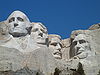
October 15, 1966 3 miles west of Keystone off U.S. Route 16A
43°52′40″N 103°27′20″W / 43.877778°N 103.455556°WKeystone 31 Mystic Townsite Historic District August 1, 1986 Address Restricted Mystic 32 Maurice Nelson House December 2, 1998 101 E. Quincy St.
44°04′35″N 103°12′51″W / 44.076389°N 103.214167°WRapid City 33 Nichols Funeral Home Building January 28, 2004 832 St. Joseph
44°04′59″N 103°13′57″W / 44.083056°N 103.2325°WRapid City 34 Otho Mining District December 15, 2004 13380 Greyhound Gulch
43°51′15″N 103°23′04″W / 43.854167°N 103.384444°WOtho 35 Pennington County Courthouse May 28, 1976 301 St. Joseph St.
44°04′44″N 103°13′21″W / 44.078889°N 103.2225°WRapid City 36 Quinn Methodist Church January 23, 2007 Junction of Elm and Main Sts.
43°59′22″N 102°07′40″W / 43.989444°N 102.127778°WQuinn 37 Michael Quinn House August 5, 1993 728 6th St.
44°04′40″N 103°13′36″W / 44.077778°N 103.226667°WRapid City 38 Rapid City Carnegie Library February 17, 1981 604 Kansas City St.
44°04′46″N 103°13′39″W / 44.079444°N 103.2275°WRapid City 39 Rapid City Fruit Company December 9, 1993 320 7th St.
44°05′30″N 103°13′39″W / 44.091667°N 103.2275°WRapid City 40 Rapid City Garage 
August 1, 1984 827-829 Main St.
44°04′54″N 103°13′53″W / 44.081667°N 103.231389°WRapid City 41 Rapid City High School June 28, 2010 615 Columbus St.
44°04′37″N 103°13′43″W / 44.076944°N 103.228611°WRapid City 42 Rapid City Historic Commercial District October 1, 1974 Bounded by both sides of Main, St. Joseph, 7th, and 6th Sts.; also roughly along St. Joseph and Main Sts. from Mt. Rushmore and 5th Sts.
44°04′51″N 103°13′39″W / 44.080833°N 103.2275°WRapid City Second set of boundaries represents a boundary increase 43 Rapid City Historical Museum December 20, 1988 515 West Boulevard
44°08′09″N 103°14′00″W / 44.135833°N 103.233333°WRapid City 44 Rapid City Laundry June 23, 1995 312 Main St.
44°04′50″N 103°13′16″W / 44.080556°N 103.221111°WRapid City 45 Rapid City West Boulevard Historic District December 31, 1974 Bordered by Kansas City, Fairview, 11th, 7th, and 8th Sts.; also roughly the area surrounding 9th, 10th, and 11th Sts. from Kansas City St. to St. Andrews St.
44°04′38″N 103°14′00″W / 44.077222°N 103.233333°WRapid City Second set of boundaries represents a boundary increase 46 Glenn W. Shaw House June 27, 2002 803 West St.
44°04′47″N 103°14′27″W / 44.079722°N 103.240833°WRapid City 47 Site No. 39 PN 57 May 20, 1982 Address Restricted City restricted 48 Site No. 39 PN 108 May 20, 1982 Address Restricted City restricted 49 Site No. 39 PN 438 May 20, 1982 Address Restricted City restricted 50 Site No. 39 PN 439 May 20, 1982 Address Restricted City restricted 51 Sitting Bull Crystal Cavern Dance Pavilion December 14, 1995 U.S. Route 16 northeast of Rockerville
43°58′21″N 103°18′45″W / 43.9725°N 103.3125°WRockerville 52 South Dakota Department of Transportation Bridge No. 52-575-383 December 17, 1999 Local road over Rapid Creek
43°58′01″N 102°54′31″W / 43.966944°N 102.908611°WCaputa 53 South Dakota Department of Transportation Bridge No. 52-824-300 December 17, 1999 Local road over the Cheyenne River
44°04′52″N 102°24′04″W / 44.081111°N 102.401111°WWasta 54 Swander Bakery Building February 9, 2001 601 12th St.
44°04′53″N 103°14′17″W / 44.081389°N 103.238056°WRapid City 55 Von Woehrmann Building April 13, 1977 U.S. Route 16
43°55′44″N 103°34′33″W / 43.928889°N 103.575833°WHill City See also
- List of National Historic Landmarks in South Dakota
- National Register of Historic Places listings in South Dakota
References
- ^ The latitude and longitude information provided in this table was derived originally from the National Register Information System, which has been found to be fairly accurate for about 99% of listings. For about 1% of NRIS original coordinates, experience has shown that one or both coordinates are typos or otherwise extremely far off; some corrections may have been made. A more subtle problem causes many locations to be off by up to 150 yards, depending on location in the country: most NRIS coordinates were derived from tracing out latitude and longitudes off of USGS topographical quadrant maps created under the North American Datum of 1927, which differs from the current, highly accurate WGS84 GPS system used by Google maps. Chicago is about right, but NRIS longitudes in Washington are higher by about 4.5 seconds, and are lower by about 2.0 seconds in Maine. Latitudes differ by about 1.0 second in Florida. Some locations in this table may have been corrected to current GPS standards.
- ^ "National Register of Historic Places: Weekly List Actions". National Park Service, United States Department of the Interior. Retrieved on November 10, 2011.
- ^ Numbers represent an ordering by significant words. Various colorings, defined here, differentiate National Historic Landmark sites and National Register of Historic Places Districts from other NRHP buildings, structures, sites or objects.
- ^ "National Register Information System". National Register of Historic Places. National Park Service. . http://nrhp.focus.nps.gov/natreg/docs/All_Data.html.
U.S. National Register of Historic Places Topics Lists by states Alabama • Alaska • Arizona • Arkansas • California • Colorado • Connecticut • Delaware • Florida • Georgia • Hawaii • Idaho • Illinois • Indiana • Iowa • Kansas • Kentucky • Louisiana • Maine • Maryland • Massachusetts • Michigan • Minnesota • Mississippi • Missouri • Montana • Nebraska • Nevada • New Hampshire • New Jersey • New Mexico • New York • North Carolina • North Dakota • Ohio • Oklahoma • Oregon • Pennsylvania • Rhode Island • South Carolina • South Dakota • Tennessee • Texas • Utah • Vermont • Virginia • Washington • West Virginia • Wisconsin • WyomingLists by territories Lists by associated states Other Municipalities and communities of Pennington County, South Dakota Cities 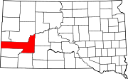
Towns CDPs Unincorporated
communitiesCaputa | Johnson Siding | Owanka | Rockerville | Scenic | Silver City | Three Forks
Footnotes ‡This populated place also has portions in an adjacent county or counties
Categories:- Pennington County, South Dakota
- National Register of Historic Places in South Dakota by county
- Buildings and structures in Pennington County, South Dakota
-


Wikimedia Foundation. 2010.