- Ontario Highway 47
-
Highway 47
Route information Length: 34.3 km[3] (21.3 mi) Existed: October 20, 1937[1] – January 1, 1998[2] Major junctions West end:  Highway 48
East end:  Highway 12
Location Regions: York
DurhamTowns: Stouffville
Uxbridge
ScugogHighway system Ontario provincial highways
400-series • Former←  Highway 46
Highway 48  →
→King's Highway 47, also known as Highway 47 and locally as Stouffville Road, Toronto Street and Brock Street was a provincial highway in the Canadian province of Ontario. The mostly rural route travelled through the towns of Whitchurch-Stouffville, Goodwood, and Uxbridge on its east–west path between Highway 48 and Highway 12. The route was established in 1937, existing until it was transferred to the Regional Municipality of Durham in 1998.
Contents
Route description
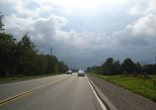 Durham Regional Highway 47 east of Highway 12
At the time of its decommissioning, the route began at Highway 48, and travelled east through the township of Stouffville along what is now York Regional Road 40 (Bloomington Road). Only a decade prior, the highway travelled through Whitchurch-Stouffville along Main Street, then turned north along the Tenth line, following it to Bloomington Road and York - Durham Line, where it curved gently into the present roadway. Within the Regional Municipality of Durham, the route passed through Goodwood. The highway then zig-zagged northeast to the town of Uxbridge. From there, the highway continued east past Durham Regional Road 23 (Lakeridge Road), ending at Highway 12 south of Greenbank.
History
The Stouffville to Greenbank Road was first assumed by the Department of Highways as Highway 47 on October 20, 1937, connecting Stouffville and Uxbridge with Highway 12, south of Greenbank.[1][4] The highway remained generally unchanged, with the exception of a short westward extension on February 10, 1954. On that day, the route was extended to meet Highway 48, which was itself extended south to Scarborough.[5]
During the early-1990s, Highway 47 was rerouted north of Whitchurch-Stouffville, following Bloomington Road instead of Tenth Line and Main Street. The gentle curve at the York–Durham boundary was removed and a signalized intersection created in its place.[citation needed] On January 1, 1998, the responsibility for signage and maintenance of Highway 47 was transferred to the Regional Municipalities of Durham and York.[2] It was subsequently redesignated as Durham Regional Highway 47 and Main Street.[6]
Major intersections
Division Location[6] km[3] Destinations Notes York Whitchurch–Stouffville 0.0 Highway 48Continues west as Stouffville Road 2.1  Regional Road 69 (Ninth Line)
4.2  Regional Road 14
8.6  Regional Road 40 (Bloomington Road)
 Regional Road 30 (York–Durham Line)
Bloomington Road travels west while York–Durham Line travels north–south Durham Goodwood 12.2  Regional Road 21
Uxbridge 17.1  Regional Road 1 south (Brock Road)
24.5  Regional Road 8 (Brock Street)
Western junction with Durham Regional Road 8 24.7 Regional Road 8 (Main Street)Eastern junction with Durham Regional Road 8 27.0  Regional Road 23 (Lakeridge Road)
Scugog 34.3  Highway 7 / Highway 12
1.000 mi = 1.609 km; 1.000 km = 0.621 mi
Concurrency terminus • Closed/Former • Incomplete access • UnopenedReferences
- ^ a b Annual Report (Report). Department of Highways. March 31, 1938. p. 81.
- ^ a b Highway Transfers List "Who Does What" (Report). Ministry of Transportation of Ontario. June 20, 2001. p. 2.
- ^ a b Highway Planning Office (1989). Provincial Highways Distance Table. Ministry of Transportation of Ontario. p. 64.
- ^ Department of Highways (1937/38). Official Road Map (Map). Section L7–8.
- ^ Annual Report (Report). Department of Highways. March 31, 1954. p. 155.
- ^ a b Peter Heiler (2010). Ontario Back Road Atlas (Map). Cartography by MapArt. p. 31, section E33–G25. ISBN 978-1-55198-226-7.
See also
- List of Durham Regional Roads
- List of York Regional Roads
Regional Roads in York Region, Ontario North-south East-west Categories:- Defunct Ontario provincial highways


Wikimedia Foundation. 2010.