- Moretonhampstead
-
Coordinates: 50°39′37″N 3°46′02″W / 50.6603°N 3.7671°W
Moretonhampstead 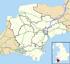
 Moretonhampstead
Moretonhampstead shown within DevonPopulation 1,536 [1](2001 Census) OS grid reference SX752860 - London 215 miles (346 km) Parish Moretonhampstead District Teignbridge Shire county Devon Region South West Country England Sovereign state United Kingdom Post town NEWTON ABBOT Postcode district TQ13 Dialling code 01647 Police Devon and Cornwall Fire Devon and Somerset Ambulance South Western EU Parliament South West England UK Parliament Teignbridge Website http://www.moretonhampstead.org.uk/ List of places: UK • England • Devon Moretonhampstead lies on the edge of Dartmoor and is notable for having the longest one-word name of any place in England. The parish church is dedicated to St. Andrew.[2] Moretonhampstead is twinned with Betton in France.
Contents
History
The central region of Devon was occupied by the Saxons soon after 682 AD. It was divided into vast estates, and one of these divisions included all land within the boundaries of the rivers Teign and Bovey, with Mor Tun as its major settlement. The present parish of over 6,000 acres (24 km²) is the residue of that ancient crown lordship. The Domesday Book (1086 AD) shows that the manor of Moreton, with some neighbouring manors, supported upwards of 5,000 sheep. Wool and (in later years) the manufacture of woollen cloth formed the basis of the town's economy for over 700 years. The economy was evidently healthy when the town established a water-powered fulling mill before the end of the 13th century.
In 1207 AD King John granted a weekly market and an annual five-day fair, indicating that Moretonhampstead had developed into an important local community. The town grew steadily through the Middle Ages and remained prosperous until the end of the 17th century, when the wool industry began to decline. The town continued to be a local trading centre and a rest stop for travellers on the difficult routes across Dartmoor and from Exeter and Newton Abbot.
A series of fires in the 20th century destroyed many of Moretonhampstead's ancient buildings, but sufficient still remains to demonstrate the Saxon and Medieval heritage, and the later industrial prosperity. Much of the town is designated a conservation area, with many listed buildings of architectural and historic interest. The whole parish is within Dartmoor National Park.
The Sparrowhawk
When King John granted the town its charter during the 13th century, the rent was set as one sparrowhawk per year. The bird has become something of a symbol for the town and will be incorporated into works of public art under development by an artist in residence Roger Dean.
Places of interest
The Cross Tree
The Cross Tree, immortalised by R. D. Blackmore in the book "Christowell" is now only represented by a cross minus its shaft, which is enclosed near the almshouses. This famous dancing tree, a fine old elm, cut and clipped in the form of a punch bowl (by which name it was also known), has long since disappeared, and in its place a beech tree has been planted. It was around the original tree that the village lads and lasses would dance and it recorded that French officers on parole from Dartmoor Prison at Princetown during the Napoleonic Wars, "did assemble around the Cross Tree with their Band".
Alms houses
Standing behind the Cross Tree are the famous almshouses, built in solid granite. The date of 1637 on the outside is actually the date they were refurbished. Recent research has shown that the main core of these buildings are at least two hundred years older.
Early in the 19th century the building was converted from two tenements into four and the facade was damaged. By 1938 they had fallen into disrepair. In 1940 they were purchased for the town and converted back into two tenements. In 1952 they were purchased by the National Trust.
Tourism
Moretonhampstead relies heavily on tourism, and has done so for a long time.[3] Its central position on Dartmoor makes it an ideal base to explore both Dartmoor and Devon. The central part of the town stands at an altitude of 700 feet (210 m) but a short stroll within the parish will elevate the walker to beyond 1,100 feet (340 m) and afford spectacular views of the surrounding area Moretonhampstead has four pubs and three cafes. There is a wide selection of hotels, bed and breakfast, self-catering and camping accommodation and the visitor will find all one is likely to need in the busy local shops.
Moretonhampstead has a good range of sporting facilities and the great expanse of Dartmoor makes it popular with ramblers and cyclists, in particular for mountain biking. No part of the National Park is more than a one hour drive away and most of the well-known beauty spots considerably less.
Events
Moretonhampstead has an annual carnival, held on the fourth Thursday in August which raises funds for local groups and associations.
Other events include a fireworks night, annual pantomime, food and drink festival and music events spread throughout the year
Transport
Moretonhampstead railway station was opened by the Moretonhampstead and South Devon Railway on the south side of the town on 26 June 1866. It closed to passengers on 28 February 1959, although goods trains continued until 6 April 1964. After this the goods shed and engine shed continued to be used for many years by a commercial road haulage business.
Bus services are from the car park just west of the town centre and include services to Exeter (359/173) and Plymouth (82).
Sport and recreation
Moretonhampstead has a King George's Field as a memorial to King George V.
References
- ^ Neighbourhood Statistics - Parish Headcounts
- ^ Ecclesiastical Antiquities of Devon: Being Observations on Many Churches in Denonshire. George Oliver and John Pike Jones (editors), 1828, Exeter: E. Woolmer.
- ^ The Beauties of England and Wales, or Delineations, Topographical, Historical and Descriptive of Each County, Vol IV. John Britton and Edward Wedlake Brayley. 1803. London.
External links
- Moretonhampstead at the Open Directory Project
- Moretonhampstead - Moretonhampstead Development Trust
- Moretonhampstead History Society
- Moretonhampstead Primary School
Settlements of Dartmoor, Devon Ashburton · Belstone · Bovey Tracey · Brentor · Bridestowe · Buckfastleigh · Buckland-in-the-Moor · Chagford · Drewsteignton · Gidleigh · Haytor · Hexworthy · Holne · Ilsington · Ivybridge · Lustleigh · Lydford · Manaton · Mary Tavy · Moretonhampstead · Okehampton · Peter Tavy · Ponsworthy · Postbridge · Poundsgate · Princetown · Shaugh Prior · Sheepstor · Sourton · South Brent · South Tawton · South Zeal · Sticklepath · Tavistock · Walkhampton · Widecombe-in-the-Moor · Yelverton
Categories:- Market towns in Devon
- Dartmoor
- Towns in Devon
- Civil parishes in Devon

Wikimedia Foundation. 2010.