- Dartmouth, Devon
-
Coordinates: 50°21′04″N 3°34′44″W / 50.351°N 3.579°W
Dartmouth 
Dartmouth from the River Dart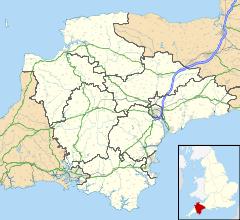
 Dartmouth
Dartmouth shown within DevonPopulation 5,512 (2001) OS grid reference SX877514 Parish Dartmouth District South Hams Shire county Devon Region South West Country England Sovereign state United Kingdom Post town DARTMOUTH Postcode district TQ6 Dialling code 01803 Police Devon and Cornwall Fire Devon and Somerset Ambulance South Western EU Parliament South West England UK Parliament Totnes List of places: UK • England • Devon Dartmouth is a town and civil parish in the English county of Devon. It is a tourist destination set on the banks of the estuary of the River Dart, which is a long narrow tidal ria that runs inland as far as Totnes. It lies within the South Devon Area of Outstanding Natural Beauty and South Hams District, and has a population of 5,512.[1]
Contents
History
Dartmouth was of strategic importance as a deep-water port for sailing vessels. The port was used as the sailing point for the Crusades of 1147 and 1190, and a creek close to Dartmouth Castle is supposed by some to be named for the vast fleets which assembled there (Warfleet Creek). It was a home of the Royal Navy from the reign of Edward III and was twice surprised and sacked during the Hundred Years' War, after which the mouth of the estuary was closed every night with a great chain. The narrow mouth of the Dart is protected by two fortified castles, Dartmouth Castle and Kingswear Castle. Originally Dartmouth's only wharf was Bayard's Cove, a relatively small but picturesque area protected by a fort at the southern end of the town.
In 1373 Geoffrey Chaucer visited and among the pilgrims in his Canterbury Tales
- A schipman was ther, wonyng fer by weste;
- For ought I wost, he was of Dertemouthe.
Notwithstanding Dartmouth's connections with the crown and respectable society, it was a major base for privateering (state sanctioned or licensed piracy) in medieval times. John Hawley or Hauley,[2] a licensed privateer and sometime mayor of Dartmouth [3] is reputed to be a model for Chaucer's "schipman".
One of the most attractive old streets is Smith Street and is the earliest street in Dartmouth to be recorded by name (in the 13th century). Several of the houses on the street are originally late 16th century or early 17th century and likely rebuilt on the site of earlier medieval dwellings. The street name undoubtedly derives from the smiths and shipwrights who built and repaired ships here when the tidal waters reached as far as this point. Smith Street was also the site of the town pillory in medieval times.
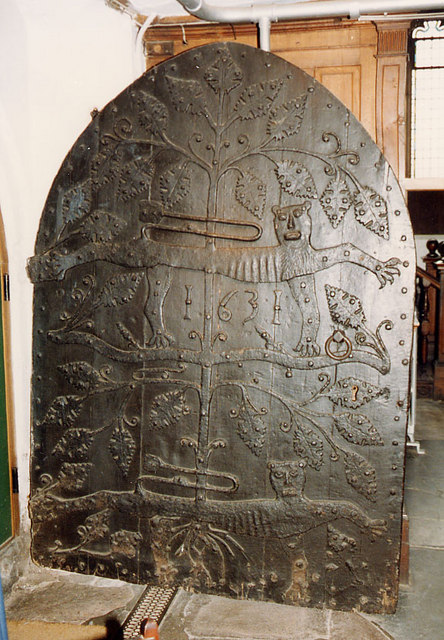
 Medieval church door of St Saviour's (Source: John Salmon)
Of particular note is St Saviour's church constructed in 1335 and consecrated in 1372. It contains a splendid pre-reformation oak rood screen built in 1480 and several other handsome monuments including the tomb of John Hawley (d. 1408) and his two wives covered with a large brass plate effigy of all three. A large medieval ironwork door is decorated with two leopards of the Plantagenets and is possibly the original portal. Although it is dated "1631", this is thought to be the date of a subsequent refurbishment coincidental with major renovations of the church in the 17th century.[4] The gallery of the church is decorated with the heraldic crests of prominent local families and is reputed to be constructed of timbers from ships captured during the defeat of the Spanish Armada, although this has not been categorically substantiated.
Henry Hudson put into Dartmouth on his return from America, and was arrested for sailing under a foreign flag. The Pilgrim Fathers put into Dartmouth's Bayard's Cove, en-route from Southampton to America. They rested a while before setting off on their journey in the Mayflower and the Speedwell on 20 August 1620. About 300 miles west of Land's End, they realised that the Speedwell was unseaworthy and returned to Plymouth. The Mayflower departed alone to complete the crossing to Cape Cod. Dartmouth's sister city is Dartmouth, Massachusetts.
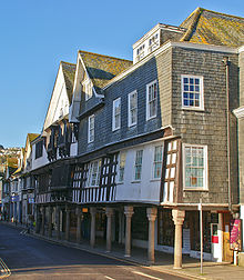 The Butterwalk
The town contains many medieval and Elizabethan streetscapes and is patchwork of narrow lanes and stone stairways. A significant number of the historic buildings are listed.[5] One of the most obvious is the Butterwalk, built 1635 to 1640. Its intricately carved wooden fascia is supported on granite columns. Charles II held court in the Butterwalk whilst sheltering from storms in 1671 in a room which now forms part of Dartmouth Museum.[6] Much of the interior survives from that time.
The Royal Castle Hotel was built in 1639 on the then new quay. The building was refronted in the 19th century, and as the new frontage is itself listed, it is not possible to see the original which lies beneath. A claimant for the oldest building is a former merchant's house in Higher Street, now a Good Beer Guide listed public house called the Cherub, built circa 1380. Agincourt House (next to the Lower Ferry) is also 14th century.
Dartmouth sent numerous ships to join the English fleet that attacked the Armada, including the Roebuck, Crescent and Hart.[7] The Neustra Señora del Rosario, the Spanish Armada's "payship" commanded by Admiral Pedro de Valdés, was captured along with all its crew by Sir Francis Drake. It was reportedly anchored in the river Dart for more than a year and the crew were used as labourers on the nearby Greenway Estate which was the home of Sir Humphrey Gilbert and his half-brother Sir Walter Raleigh. Greenway was subsequently the home of Dame Agatha Christie.[8]
The remains of a fort at Gallants Bower just outside the town are some of the best preserved remains of a Civil War defensive structure. The fort was built by Royalist occupation forces in c. 1643 to the south east of the town, with a similar fort at Mount Ridley on the opposite slopes of what is now Kingswear. The Parliamentarian General Fairfax attacked from the north in 1646, taking the town and forcing the Royalists to surrender, after which Gallants Bower was demolished.
Nineteenth century
The made up embankment which today extends the whole length of the town's riverbank is the result of 19th century land reclamation, started in earnest when the town played host to a large number of prisoners of war from the Napoleonic Wars which formed a captive workforce. Before this, what is now the town centre was almost entirely tidal mud flats.
The Royal National Lifeboat Institution opened a lifeboat station at the Sand Quay in 1878 but it was closed in 1896. In all this time only one effective rescue was made by the lifeboat.[9]
Twentieth century
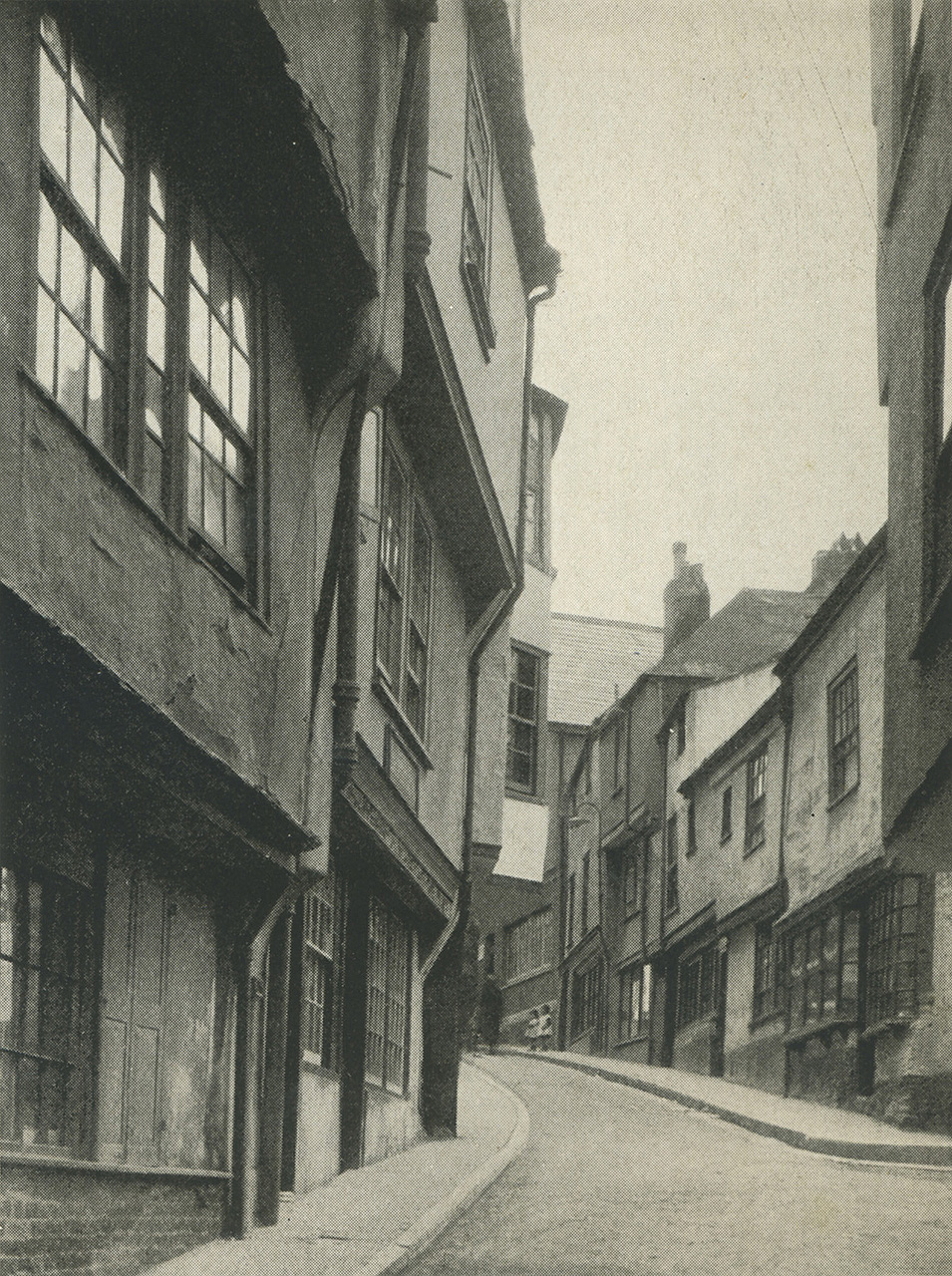
 Smith Street circa 1930
In the latter part of World War II the town was a base for American forces and one of the departure points for Utah Beach in the D Day landings. Much of the surrounding countryside was closed to the public while it was used by US troops for practise landings and manoeuvres.
In 2010, a fire seriously damaged numerous historical properties in Fairfax Place and Higher Street. Several were Tudor and Grade I or Grade II listed buildings.[10]
Governance
The town was an ancient borough, incorporated by Edward III, known formally as Clifton-Dartmouth-Hardness, and consisting of the three parishes of St Petrox, St Saviour and Townstall, and incorporating the hamlets of Ford, Old Mill and Norton.[11] It was reformed under the Municipal Corporations Act 1835. The town returned two members of parliament from the 13th century until 1835, after which one MP was elected until the town was disenfranchised in 1868. It remained a municipal borough until 1974, when it was merged into the South Hams district, and became a successor parish of Dartmouth with a town council.[12][13]
Dartmouth Town Council is the lowest of three tiers of local government. It consists of 16 councillors representing the two wards of Clifton and Townstall.[14] At the second tier, Dartmouth forms part of the Dartmouth and Kingswear ward of South Hams District Council, which returns three councillors.[15] At the upper tier of local government Dartmouth and Kingswear Electoral Division elects one member to Devon County Council.[16]
Culture
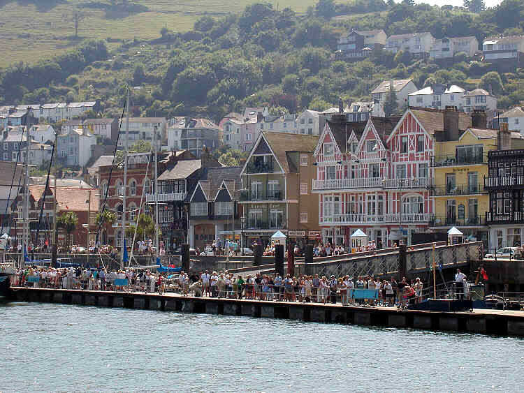
The Port of Dartmouth Royal Regatta takes place annually over three days at the end of August.
Bayard's Cove has been used in several television productions, including The Onedin Line[17] a popular BBC television drama series that ran from 1971 to 1980.
Climate
The nearest Met Office weather station is Slapton, about 5 miles South south west of Dartmouth and a similar distance from the coast. As with the rest of the British Isles and South West England, the area experiences a maritime climate with cool summers and mild winters - this is particularly pronounced due to its position near the coast - extremes range from a record low of just −8 °C (17.6 °F) in January 1987[18] upto a record high of 30.5 °C (86.9 °F) during June 1976.[19]
Climate data for Slapton 32m asl, 1971-2000, Extremes 1960- Month Jan Feb Mar Apr May Jun Jul Aug Sep Oct Nov Dec Year Record high °C (°F) 14.6
(58.3)14.5
(58.1)19.5
(67.1)20.5
(68.9)24.0
(75.2)30.5
(86.9)28.0
(82.4)28.5
(83.3)25.0
(77.0)21.9
(71.4)17.7
(63.9)15.5
(59.9)30.5
(86.9)Average high °C (°F) 9.0
(48.2)8.9
(48.0)10.6
(51.1)12.5
(54.5)15.5
(59.9)18.3
(64.9)20.5
(68.9)20.5
(68.9)18.1
(64.6)14.9
(58.8)11.6
(52.9)9.9
(49.8)14.19
(57.55)Average low °C (°F) 3.5
(38.3)3.5
(38.3)4.4
(39.9)5.3
(41.5)8.1
(46.6)10.4
(50.7)12.7
(54.9)12.9
(55.2)11.1
(52.0)9.0
(48.2)5.9
(42.6)4.6
(40.3)7.62
(45.71)Record low °C (°F) −8
(17.6)−6.8
(19.8)−6.5
(20.3)−2.5
(27.5)−0.1
(31.8)2.6
(36.7)6.2
(43.2)6.1
(43.0)3.9
(39.0)0.2
(32.4)−2.2
(28.0)−4.5
(23.9)−8
(18)Precipitation mm (inches) 122.03
(4.8043)103.38
(4.0701)89.48
(3.5228)63.04
(2.4819)63.03
(2.4815)60.0
(2.362)53.45
(2.1043)68.83
(2.7098)79.8
(3.142)102.37
(4.0303)113.19
(4.4563)135.54
(5.3362)1,054.14
(41.5016)Source: Royal Dutch Meteorological Institute/KNMI[20] Transport
Dartmouth is linked to Kingswear, on the other side of the River Dart, by three ferries. The Higher Ferry and the Lower Ferry are both vehicular ferries. The Passenger Ferry, as its name suggests, carries only passengers, principally to connect with the Paignton and Dartmouth Steam Railway at Kingswear station. The nearest bridge across the Dart is in Totnes, some 11 miles (18 km) away by road.[21]
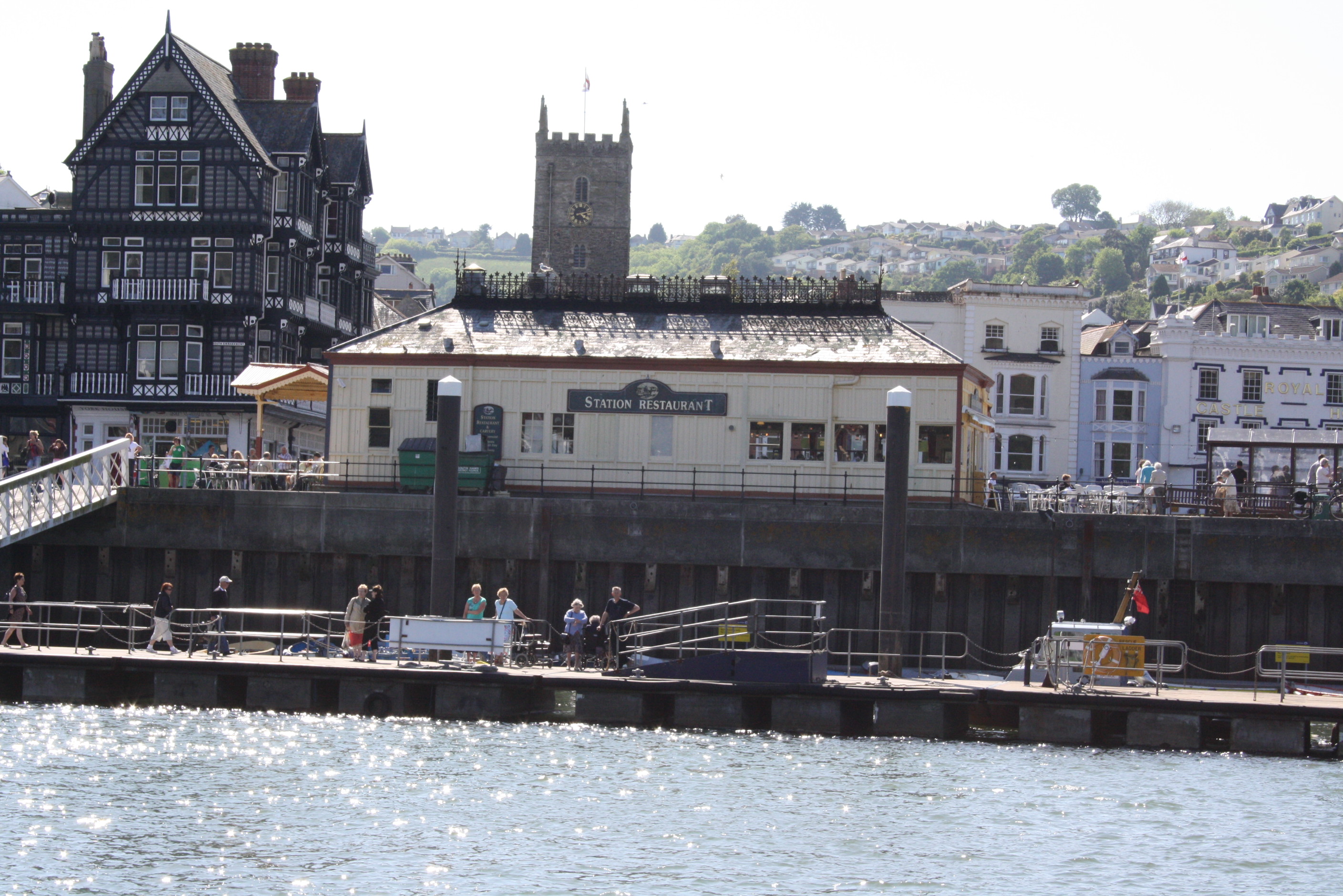
 Dartmouth station building, now a restaurant.
The A379 road runs through Dartmouth, linking the town to Slapton and Kingsbridge to the southwest and to Torbay to the east across the Higher Ferry. The A3122 connects Dartmouth to a junction with the A381, and hence to both Totnes and a more direct route to Kingsbridge. First Devon & Cornwall provides local town bus services and links to Totnes, Torquay, Kingsbridge and Plymouth. Stagecoach Devon provides links to the Torbay resorts of Brixham, Paignton and Torquay from Kingswear via the ferry.
No railway has ever run to Dartmouth, but the town does have a railway station,[22] although it is now a restaurant. The railway line to Kingswear was opened in 1864, the original plans for the Dartmouth and Torbay Railway line took the line across a bridge and into the town. Opposition from local seamen and merchants saw the route diverted to Kingswear on the opposite side of the river, but this occurred after the station had been built at Dartmouth. The railway terminated at a station called "Kingswear for Dartmouth" (now on the Paignton and Dartmouth Steam Railway) and a ferry took passengers across the river to the station at Dartmouth railway station, which had a dedicated pontoon. British Railways closed the line to mainline passenger trains in 1973, but re-opened as a heritage line and has run as one ever since.
 Kingswear seen from Dartmouth
Dart Lifeboat Station was opened in 2007, the first time that a lifeboat had been stationed in the town since 1896. It has initially been kept in a temporary building in Coronation Park.[9]
Education
On the outskirts of the town is the Royal Navy's officer training college (Britannia Royal Naval College), where all officers of the Royal Navy and many foreign naval officers are trained.
Schools
Dartmouth has one secondary school formerly (Dartmouth Community College) now Dartmouth Academy an all-through school for those aged 3–18, and two primary schools (Dartmouth Primary school (now part of Dartmouth Academy) and St John the Baptist R.C. Primary School). Dartmouth Community College and Dartmouth Primary School are part of the Dartmouth Learning Campus; as from September 2007, Dartmouth Community College is part of a federation with Dartmouth Primary School and Nursery meaning that the two schools share one governing body for pupils aged 1 to 19.
Notable former and present residents
Thomas Newcomen, the inventor of the atmospheric engine – the first successful steam-powered pumping engine – was born in Dartmouth in 1663. The location of his house in Lower Street is marked with a plaque, although the building itself was demolished (and elements incorporated into local architect Thomas Lidstone's house on Ridge Hill) in the 19th century to make way for a new road which was named after Newcomen. An 18th century working Newcomen steam engine is on display in the town.
The town was home to the civil engineer and calculating prodigy George Parker Bidder (1806–1878), who is notable for his work on railways over much of the world, as well as the docks of the East End in the Port of London. Bidder served on the town council, and his expertise was instrumental in draining the area which is now the centre of the town, but was then part of the River Dart. He also undertook pioneering work on steam trawling whilst living in the town. Bidder died at his home at Paradise Point near Warfleet Creek and is buried at nearby Stoke Fleming.
Flora Thompson lived in Above Town between 1928 and 1940, writing Lark Rise and Over to Candleford during this time. The books were later combined into a single volume with the later Candleford Green to form the well-known Lark Rise to Candleford. She is buried at Longcross Cemetery.
The noted stage and film actress Rachel Kempson (1910–2003) was born in Dartmouth. She was the wife of Sir Michael Redgrave and mother of Vanessa, Lynn and Corin, and published her autobiography, Life Among the Redgraves, in 1988.
Gordon Onslow Ford (1912–2003), a leading British surrealist painter, attended the Royal Naval College.
References
- ^ Office for National Statistics : Census 2001 : Parish Headcounts : South Hams Retrieved 27 January 2010
- ^ http://www.devonperspectives.co.uk/johnhawley.html
- ^ http://www.dartmouth-history.org.uk/content_images/upload/Town_Mayors.htm
- ^ http://www.roughwood.net/ChurchAlbum/Devon/Dartmouth/Dartmouth-St-Saviour.htm
- ^ http://britishlistedbuildings.co.uk/england/devon/dartmouth
- ^ "The King's Room at Dartmouth Museum". Dartmouth Museum. http://dartmouthmuseum.org/collections/kings-room/index.html. Retrieved 29 July 2011. "It was in this magnificent room that King Charles II was entertained in July 1671, when storms forced him to seek shelter in Dartmouth."
- ^ http://www.dartmouth-history.org.uk/content_images/upload/Russells_Dartmouth.pdf
- ^ http://www.historic-uk.com/DestinationsUK/Dartmouth.htm
- ^ a b Leach, Nicholas (2009). Devon's Lifeboat Heritage. Chacewater: Twelveheads Press. pp. 19–20. ISBN 0-906294-72-7.
- ^ "Dartmouth's Tudor buildings destroyed by chip shop fire". BBC News. 29 May 2010. http://news.bbc.co.uk/2/hi/england/devon/10189310.stm. Retrieved 30 May 2010.
- ^ Pigot & Co.'s Devonshire (1830) GenUKi
- ^ The English Non-metropolitan Districts (Definition) Order 1972 (S.I. 1972 No. 2039)
- ^ The Local Government (Successor Parishes) Order 1973 (S.I. 1973 No. 1110)
- ^ Dartmouth Town Councillors, Dartmouth Town Council, accessed March 21, 2008
- ^ "Election of District Councillors for Dartmouth and Kingswer". South Hams District Council. http://www.southhams.gov.uk/20110408_dis_notice_of_poll_-_dartmouth_and_kingswear.pdf. Retrieved 15 April 2011.
- ^ Division 36: Dartmouth and Kingswear, Devon County Council, accessed March 21, 2008
- ^ "Things to Do". Dartmouth Museum. http://dartmouthmuseum.org/things-to-do/#bayardscove. Retrieved 19 August 2011. "Bayards Cove was used in the BBC period drama The Onedin Line to represent the wharves and buildings of Liverpool Docks."
- ^ "1987 temperature". KNMI. http://eca.knmi.nl/utils/monitordetail.php?seasonid=7&year=1987&indexid=TNn&stationid=1815.
- ^ "1976 temperature". KNMI. http://eca.knmi.nl/utils/monitordetail.php?seasonid=12&year=1976&indexid=TXx&stationid=1815.
- ^ "Slapton Climate". KNMI. http://eca.knmi.nl/utils/mapserver/anomaly.php?indexcat=**&indexid=TNn&year=1987&seasonid=7&create_image=true&minx=-401845.23809526&miny=-4687142.8571428&maxx=-185178.57142857&maxy=-4524642.8571428&MapSize=560%2C420&imagewidth=560&imageheight=420&mainmap.x=280&mainmap.y=208&CMD=QUERY_POINT&CMD=QUERY_POINT#bottom. Retrieved 12 Nov 2011.
- ^ "Dart Harbour : Ferries". The Dart Harbour and Navigation Authority. http://www.dartharbour.org/harbour-river-guide/ferries/. Retrieved 2008-09-18.
- ^ http://www.southdevonaonb.org.uk/text.asp?PageId=200
External links
- Dartmouth at the Open Directory Project
- Charles Oman, "Dartmouth and Kingswear Castles: Twin Dart estuary defenders"
- Dartmouth Museum
Ceremonial county of Devon Unitary authorities Boroughs or districts Major settlements - Ashburton
- Axminster
- Barnstaple
- Bideford
- Bovey Tracey
- Bradninch
- Brixham
- Buckfastleigh
- Budleigh Salterton
- Chagford
- Chudleigh
- Chulmleigh
- Colyton
- Crediton
- Cullompton
- Dartmouth
- Dawlish
- Exeter
- Exmouth
- Great Torrington
- Hartland
- Hatherleigh
- Holsworthy
- Honiton
- Ilfracombe
- Ivybridge
- Kingsbridge
- Kingsteignton
- Lynton
- Modbury
- Moretonhampstead
- Newton Abbot
- North Tawton
- Northam
- Okehampton
- Ottery St Mary
- Paignton
- Plymouth
- Plympton
- Princetown
- Salcombe
- Seaton
- Sidmouth
- South Molton
- Tavistock
- Teignmouth
- Tiverton
- Torquay
- Totnes
See also: List of civil parishes in Devon
Rivers Topics - Devon County Council
- Economy
- Flag
- History
- Notable people
- Dartmoor
- Exmoor
- Jurassic Coast
- Towns by population
- South West Coast Path
- Museums
Non-metropolitan district of South Hams Civil parishes Ashprington • Aveton Gifford • Berry Pomeroy • Bickleigh • Bigbury • Blackawton • Brixton • Buckland Tout Saints • Charleton • Chivelstone • Churchstow • Cornwood • Cornworthy • Dartington • Dartmouth • Dean Prior • Diptford • Dittisham • East Allington • East Portlemouth • Ermington • Frogmore and Sherford • Halwell and Moreleigh • Harberton • Harford • Holbeton • Holne • Ivybridge • Kingsbridge • Kingston • Kingswear • Littlehempston • Loddiswell • Malborough • Marldon • Modbury • Newton and Noss • North Huish • Rattery • Ringmore • Salcombe • Shaugh Prior • Slapton • South Brent • South Huish • South Milton • South Pool • Sparkwell • Staverton • Stoke Fleming • Stoke Gabriel • Stokenham • Strete • Thurlestone • Totnes Ugborough • Wembury • West Alvington • West Buckfastleigh • Woodleigh • YealmptonBold text denotes a parish council refered to as a "town council" i.e. towns.Categories:- Civil parishes in South Hams
- Ports and harbours of the English Channel
- Ports and harbours of Devon
- Seaside resorts in England
- Towns in Devon


Wikimedia Foundation. 2010.