- Magor services
-
Magor Services 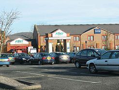
County Monmouthshire Road M4 (also accessible to traffic on the B4245) Coordinates 51°35′16″N 2°50′14″W / 51.58786°N 2.83713°WCoordinates: 51°35′16″N 2°50′14″W / 51.58786°N 2.83713°W Operator Roadchef Previous operator(s) Granada, First Date opened 1996 Website www.roadchef.com Magor services (In Welsh: Gwasanaethau Magwyr) is a motorway service station on the M4 in Monmouthshire, Wales.
Contents
History
The services originally opened in 1996 along with the Second Severn Crossing and under First became dilapidated and lacking in facilities. In April 2007, the services were even voted the worst in Britain by members of Vans United.[1] After selling their other two motorway services (Bridgwater and Rivington, aka Bolton West) to Moto and Eurogarages respectively, First then went quiet until, in August 2011, news broke that Magor services had been sold to Roadchef.[2][3][4]
Facilities
The following facilities are available at Magor:[5][6]
- Costa Coffee (to be superseded by a larger outlet from October 2011)
- The Burger Company (to be replaced by a McDonalds from February 2012)
- Self Service Restaurant (to be rebranded as a Hot Food Company/Restbite restaurant soon)
- WHSmith (opening soon)
- Toilets
- Cash Machine
- Esso fuel
The motel has been rebranded from First Lodge to Days Inn. [7]
Location
The services are located at Magor in Monmouthshire near Newport, south Wales and are located off the M4 at Junction 23A.
References
- ^ http://motorwayservicesonline.co.uk/Magor
- ^ http://motorwayservicesonline.co.uk/wiki/index.php?title=Magor&diff=next&oldid=17297
- ^ http://motorwayservicesonline.co.uk/First
- ^ http://www.roadchef.com/motorway-service-area-magor.html
- ^ http://www.roadchef.com/motorway-service-area-magor.html
- ^ http://motorwayservicesonline.co.uk/wiki/index.php?title=Magor&diff=next&oldid=17297
- ^ http://motorwayservicesonline.co.uk/First
External links
Previous:
Leigh Delamere
Severn View (M48)Motorway service stations on the
M4 MotorwayNext:
Cardiff GateCategories:- 1996 establishments
- M4 motorway service stations
- Buildings and structures in Monmouthshire
- Transport in Monmouthshire

Wikimedia Foundation. 2010.