- Minninglow
-
 Minninglow Embankment on the High Peak Trail, formerly the Cromford and High Peak Railway
Minninglow (or Minning Low) is a hill in the Peak District National Park in Derbyshire, located within the White Peak area at grid ref SK209573. Within the clump of trees crowning the hill is a round barrow containing Neolithic burial chambers.
Although it is within 200 metres of the High Peak Trail between Parwich and Longcliffe, there is no public right of way to the site. Between January 31 2007 and January 31 2017, however, concessionary access has been granted by the landowner, allowing the public to walk to and explore the site.
About one kilometre north-west of Minninglow hill is the massive Minninglow Embankment on the former Cromford and High Peak Railway, the trackbed of which now forms the High Peak Trail. This listed structure, constructed from local limestone and earth in the late 1820s, is a pre-Victorian example of civil engineering on the grand scale. There is access from the car park and picnic site about 200 metres further along the High Peak Trail at grid ref SK194581.
External link
Marilyns 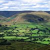
Other peaks Abney Low · Aleck Low · Allman Well Hill · Alport Height · Axe Edge Moor · Back Tor · Beeley Moor · Big Moor · Blake Low · Blakelow Hill · Bleaklow · Bole Hill (Peak District) · Bolehill (Peak District) · Britland Edge Hill · Brittain's Plantation · Brown Knoll · Bunster Hill · Burton Bole End · Calver Peak · Chrome Hill · Crook Hill · Dead Edge End · Derwent Edge · Durham Edge · Eccles Pike · Eldon Hill · Emlin · Eyam Moor - Sir William Hill · Fin Cop · Gautries Hill · Gibraltar Rocks · Grindslow Knoll · Harborough Rocks · Hare Edge Hill · Hartcliff Hill · Haven Hill · Hawks Low · The Height · Heights of Abraham · Higger Tor · High Field · High Low · High Neb · High Wheeldon · Higher Shelf Stones · Houndkirk Hill · Lees Moor · Longstone Moor · Lord's Seat · Lose Hill · Lost Lad · Low Moor · Mam Tor · Margery Hill · Merryton Low · Middleton Moor · Minninglow Hill · Nelson's Monument · Parkhouse Hill · Pike Low · Pikenaze Hill · The Roaches · Rock Hall (Peak District) · Shutlingsloe · Slipper Low · Snailsden Pike End · Snels Low · Stanage Edge · Stanton Moor · Tegg's Nose · Thorpe Cloud · Totley Moor · Ughill Height · Wardlow Hay Cop · West Nab · Wetton Hill · Whaley Moor · Wibben Hill · Win Hill · Wire Stone · Wolfscote HillList of peaks of the Peak District Coordinates: 53°06′54″N 1°40′37″W / 53.115°N 1.677°W
Categories:- Mountains and hills of the Peak District
- Derbyshire geography stubs


Wikimedia Foundation. 2010.