- Black Moshannon State Park
Geobox Protected Area
name = Black Moshannon State Park
native_name =
other_name =
other_name1 =
category_local = Pennsylvania State Park
category_iucn = III
image_size = 300
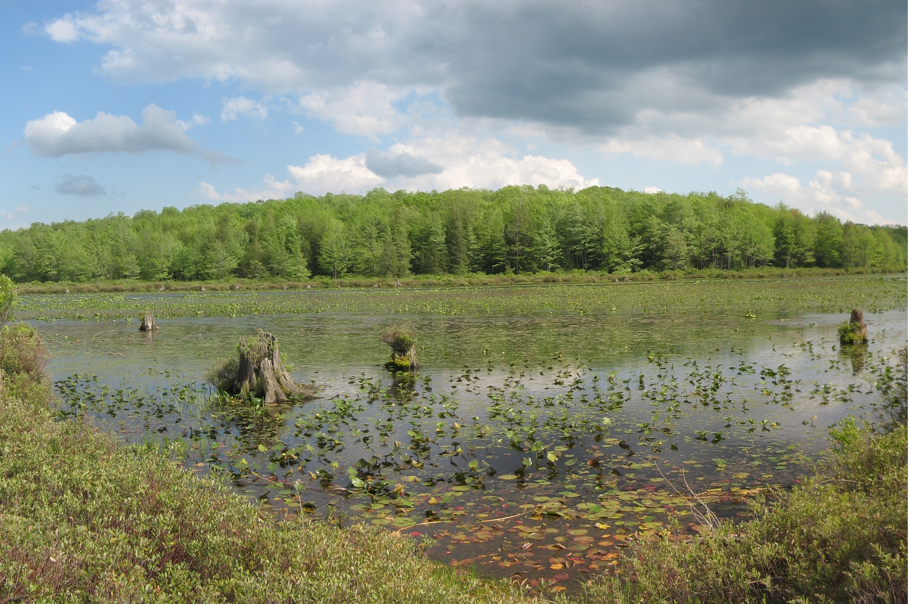
image_caption = View of bog and lake from the bog trail in the Black Moshannon Bog Natural Area at Black Moshannon State Park
etymology_type = Named for
etymology =Black Moshannon Creek
country = United States
state = Pennsylvania
region_type = County
region = Centre
district_type = Township
district = Rush
city_type =
city =
city1 =
location =
lat_d = 40
lat_m = 53
lat_s = 54
lat_NS = N
long_d = 78
long_m = 03
long_s = 23
long_EW = W
location_note =cite web
url = Gnis3|1169720
title = Black Moshannon State Park
date = August 2, 1979
work =Geographic Names Information System
publisher =United States Geological Survey
accessdate = 2007-12-12 ] cite map |scale = 1:65,000| publisher=Pennsylvania Department of Transportation , Bureau of Planning and Research, Geographic Information Division | url= ftp://ftp.dot.state.pa.us/public/pdf/BPR_pdf_files/Maps/GHS/Roadnames/centre_GHSN.pdf| title= 2007 General Highway Map Centre County Pennsylvania | accessdate= 2007-07-27 "Note: shows Black Moshannon State Park"]
elevation_imperial = 1919
elevation_round = 1
elevation_note =
area_unit = acre
area_imperial = 3394
area_round = 0
area_note =
area1_imperial =
area1_type =
length_imperial =
length_orientation =
width_imperial =
width_orientation =
highest =
highest location =
highest_lat_d =
highest_lat_m =
highest_lat_s =
highest_lat_NS =
highest_long_d =
highest_long_m =
highest_long_s =
highest_long_EW =
highest_elevation_imperial =
lowest =
lowest_location =
lowest_lat_d =
lowest_lat_m =
lowest_lat_s =
lowest_lat_NS =
lowest_long_d =
lowest_long_m =
lowest_long_s =
lowest_long_EW =
lowest_elevation_imperial =
biome =
biome_share =
biome1 =
biome1_share =
geology =
geology1 =
plant =
plant1 =
animal =
animal1 =
established_type =
established = 1937
established_note =
established1_type =
established1 =
management_body = Pennsylvania Department of Conservation and Natural Resources
management_location =
management_lat_d =
management_lat_m =
management_lat_s =
management_lat_NS =
management_long_d =
management_long_m =
management_long_s =
management_long_EW =
management_elevation =
visitation = over 350,000
visitation_note =
visitation_year =2001
free_type = Nearest city
free = Philipsburg, Pennsylvania
free1_type =
free1 =

map_caption = Location of Black Moshannon State Park in Pennsylvania
map_locator = Pennsylvania
website = [http://www.dcnr.state.pa.us/stateparks/parks/blackmoshannon.aspx Black Moshannon State Park]Black Moshannon State Park is a convert|3394|acre|ha|lk=on|sing=on Pennsylvania state park in Rush Township in Centre County,
Pennsylvania in the United States. It surrounds Black Moshannon Lake, formed by adam onBlack Moshannon Creek , which has given its name to the lake and park. The park is just west of theAllegheny Front , convert|9|mi|km|lk=on east of Philipsburg onPennsylvania Route 504 , and is largely surrounded byMoshannon State Forest . Abog in the park provides a habitat for diverse wildlife not common in other areas of the state, such ascarnivorous plant s, orchids, and species normally found farther north. As home to the " [l] argest reconstituted bog/wetland complex in Pennsylvania",cite web| url = http://www.dcnr.state.pa.us/stateparks/twenty/20parks.aspx | title = Twenty Must-See Pennsylvania State Parks | accessdate = 2007-08-08| publisher = Pennsylvania Department of Conservation and Natural Resources "Note: Despite the title, there are twenty-one parks in the list, with Colton Point andLeonard Harrison State Park s treated as one."] the park was chosen by the Pennsylvania Bureau of Parks for its "Twenty Must-See Pennsylvania State Parks" list.Humans have long used the Black Moshannon area for recreational, industrial, and subsistence purposes. The Seneca tribe used it as hunting and fishing grounds. European settlers cleared some land for farming, then clear-cut the vast stands of old-growth White Pine and Eastern Hemlock to meet the needs of a growing nation during the late 1800s. Black Moshannon State Park rose from the ashes of a depleted forest that was largely destroyed by
wildfire in the years following the lumber era. The forests were rehabilitated by theCivilian Conservation Corps during theGreat Depression of the 1930s. Many of the buildings built by the Civilian Conservation Corps stand in the park today and are protected on the list ofNational Register of Historic Places in three historic districts.Black Moshannon State Park is open year-round for recreation and has an extensive network of trails which allow
hiking , biking, and viewing the bog habitat at the Black Moshannon State Natural Area. The park is in PennsylvaniaImportant Bird Area #33, where bird watchers have recorded 175 different species. It is also home to many rare and unusual plants and animals, due to its location atop theAllegheny Plateau ; the lake is at an elevation of about convert|1900|ft|m. Much of the park is open forhunting and the lake and creek are open forfishing ,boating , andswimming . In winter it is a popular destination forcross-country skiing , and was home to a small downhillskiing area from 1967 to 1982.Picnic s andcamping are also popular, and the "Friends of Black Moshannon State Park" group promotes the park and all of the recreational activities associated with it.History
Native Americans
Humans have lived in what is now Pennsylvania since at least 10,000 BC. The first settlers were Paleo-Indian
nomad ic hunters known from theirstone tools .cite book |title = Foundations of Pennsylvania Prehistory | author = Kent, Barry C.; Smith III, Ira F.; McCann, Catherine (Editors) |year= 1971 |publisher= Commonwealth of Pennsylvania, The Pennsylvania Historical and Museum Commission |location= Harrisburg, Pennsylvania |series= Anthropological Series of the Pennsylvania Historical and Museum Commission |volume= 1 (No ISBN) ] cite book |last= Wallace |first= Paul A. W. |title= Indians in Pennsylvania | origdate = 1961 |date= 2000 | publisher= Commonwealth of Pennsylvania, The Pennsylvania Historical and Museum Commission |location= Harrisburg, Pennsylvania |isbn= 978-0892710171
"Note": For a general overview of Native American History in the West Branch Susquehanna watershed, see cite book
last = Meginness
first = John Franklin
title = History of Lycoming County, Pennsylvania: including its aboriginal history; the colonial and revolutionary periods; early settlement and subsequent growth; organization and civil administration; the legal and medical professions; internal improvement; past and present history of Williamsport; manufacturing and lumber interests; religious, educational, and social development; geology and agriculture; military record; sketches of boroughs, townships, and villages; portraits and biographies of pioneers and representative citizens, etc. etc.
date = 1892
url = http://www.usgennet.org/usa/pa/county/lycoming/history/lyco-history-01.html
accessdate = 2008-06-17
edition = 1st Edition
publisher = Brown, Runk & Co
location = Chicago, IL
id = ISBN 0-7884-0428-8
chapter = Chapter I. Aboriginal Occupation.
chapterurl = http://www.usgennet.org/usa/pa/county/lycoming/history/Chapter-01.html "Note:" ISBN refers to the Heritage Books July 1996 reprint. URL is to a scan of the 1892 version with some OCR typos.] Thehunter-gatherer s of the Archaic period, which lasted locally from 7000 to 1000 BC, used a greater variety of more sophisticated stone artefacts. TheWoodland period marked the gradual transition to semi-permanent villages andhorticulture , between 1000 BC and 1500 AD. Archeological evidence found in the state from this time includes a range of pottery types and styles, burial mounds, pipes, bows and arrow, and ornaments.Black Moshannon Creek is in the
West Branch Susquehanna River drainage basin , whose earliest recorded inhabitants were theIroquoian -speakingSusquehannock s. They were a matriarchial society that lived in largelong house s instockade d villages.Decimate d by disease and warfare with the Five Nations of theIroquois , by 1675 they had died out, moved away, or been assimilated into other tribes.cite book
last = Wallace
first = Paul A.W.
title = Indian Paths of Pennsylvania
edition = Fourth Printing
date = 1987
publisher = Pennsylvania Historical and Museum Commission
location =Harrisburg, Pennsylvania
id = ISBN 0-89271-090-X
pages = pp. 66–72 "Note:" ISBN refers to 1998 impression]After this, the lands of the West Branch Susquehanna River valley were under the nominal control of the Iroquois. The Iroquois lived in long houses, primarily in what is now
New York , and had a strong confederacy which gave them power beyond their numbers. To fill the void left by the demise of the Susquehannocks, the Iroquois encouraged displaced tribes from the east to settle in the West Branch watershed, including theLenape (or Delaware).The Seneca, members of the Iroquois Confederacy, were inhabitants in the area of Black Moshannon Lake, which was a series of
beaver ponds at the time. They and other Native Americans, including the Lenape, hunted, fished, and traded in the region. TheGreat Shamokin Path , the major native east–west path connecting the Susquehanna andAllegheny River basins, crossed Black Moshannon Creek at a ford a few miles downstream from the park; however, no trails of the indigenous peoples are recorded as having passed through the park itself. The park's convert|1|mi|1|adj=on Indian Trail for hiking and cross-country skiing recalls such native paths as it runs through an open forest ofoak andpine trees, with occasional clearings and a grove of hawthorns.The
French and Indian War (1754–1763) led to the migration of many Native Americans westward to the Ohio River basin. On November 5, 1768, the British acquired the "New Purchase" from the Iroquois in theTreaty of Fort Stanwix , including what is now Black Moshannon State Park. After theAmerican Revolutionary War , Native Americans almost entirely left Pennsylvania.While there are no known archeological sites within Black Moshannon State Park, the name "Moshannon" (pron-en|moʊˈʃænən) is derived from a Lenape (or Delaware) name for Moshannon and Black Moshannon Creeks: "Moss-hanne", which means "moose stream" or "elk stream". cite book |last=Donehoo |first= Dr. George P. |title= A History of the Indian Villages and Place Names in Pennsylvania |origdate= 1928 |url= http://www.srbc.net/pubinfo/docs/IndianNamesDataChart.PDF|format= PDF|accessdate= 2007-03-09|edition= Second Reprint Edition |date= 1999|publisher= Wennawoods Publishing |location=
Lewisburg, Pennsylvania |id= ISBN 1-889037-11-7|pages= 290|quote = ISBN refers to a 1999 reprint edition, URL is for the Susquehanna River Basin Commission's web page of Native American Place names, quoting and citing the book] The name "Black Moshannon" refers to the dark color of the water, a result of planttannin s from the local vegetation andbog .cite web
url = http://www.dcnr.state.pa.us/stateparks/parks/blackmoshannon/blackmoshannon_history.aspx
title = Black Moshannon State Park: History
accessdate = 2006-10-28
publisher = Pennsylvania Department of Conservation and Natural Resources]Lumber era
Prior to the arrival of
William Penn and his Quaker colonists in 1682, it has been estimated that up to 90 percent of what is now Pennsylvania was covered with woods: over convert|31000|sqmi|-3 of White Pine, Eastern Hemlock, and a mix ofhardwood s. cite web |url = http://www.lumbermuseum.org/history.html |title = The Pennsylvania Lumber Museum - History |accessdate = 2008-04-20 |publisher = Pennsylvania Historical and Museum Commission ] The forests near the three original counties, Philadelphia, Bucks, and Chester, were the first to be harvested, as the early settlers used the readily available timber to build homes, barns, and ships, and cleared the land for agriculture. The demand for lumber slowly increased and by the time of theAmerican Revolution the lumber industry had reached the interior and mountainous regions of Pennsylvania.Lumber became one of the leading industries in Pennsylvania. Trees were used to furnish fuel to heat homes,
tannin for the many tanneries that were spread throughout the state, and wood for construction, furniture, andbarrel making. Large areas of forest were harvested by colliers to fire iron furnaces. Rifle stocks and shingles were made from Pennsylvania timber, as were a wide variety of household utensils, and the firstConestoga wagon s. The Philadelphia–Erie Pike (present dayPennsylvania Route 504 ) opened the Black Moshannon area tosettler s by 1821. The first settlers opened the AntesTavern along the Pike, trapped fur-bearing animals, and cleared land for farming.By the mid-19th century, the demand for lumber reached the area, where Eastern White Pine and Eastern Hemlock covered the surrounding mountainsides. Lumbermen came and harvested the trees and sent them down Black Moshannon and Moshannon Creeks to the West Branch Susquehanna River, then along that to the
Susquehanna Boom andsawmill s at Williamsport.cite book |last=Taber III |first= Thomas T. |title= Williamsport Lumber Capital |date= 1995 |edition= First Edition |publisher= Paulhamus Litho, Inc. |location=Montoursville, Pennsylvania |pages= 88 |chapter= Chapter Two: The Boom — Making It All Possible (No ISBN)
"Note: For a general overview of lumber history in the West Branch Susquehanna watershed, see" cite book
last = Meginness
first = John Franklin
title = History of Lycoming County, Pennsylvania: including its aboriginal history; the colonial and revolutionary periods; early settlement and subsequent growth; organization and civil administration; the legal and medical professions; internal improvement; past and present history of Williamsport; manufacturing and lumber interests; religious, educational, and social development; geology and agriculture; military record; sketches of boroughs, townships, and villages; portraits and biographies of pioneers and representative citizens, etc. etc."
origdate = 1892
url = http://www.usgennet.org/usa/pa/county/lycoming/history/lyco-history-01.html
accessdate = 2007-06-05
edition = 1st Edition
publisher = Brown, Runk & Co.
location = Chicago, IL
id = ISBN 0-7884-0428-8
chapter = Chapter XXI Williamsport (continued)
chapterurl = http://www.usgennet.org/usa/pa/county/lycoming/history/Chapter-21.html
quote = (Note: ISBN refers to Heritage Books July 1996 reprint. URL is to a scan of the 1892 version with some OCR typos). ] Lumber was also transported by sled and wagon over the ridges and through the valleys to Philipsburg, Julian and Unionville.cite web | url = http://www.centrecountyhistory.org/history/ABCsU.html | title = The ABC's of Centre County History | accessdate = 2008-01-31 | publisher = Centre County Historical Society]The Beaver Mill Lumber Company became one of the largest single lumber operations in all of Pennsylvania, and four lumber
boomtown s, Beaver Mills, Star Mill, Underwood Mills, and Antes, altered the landscape in the Black Moshannon area. A dam was built at the site of an old beaver dam, and the mill ponds for the lumber mills flooded the old beaver ponds. The communities featuredgeneral store s,blacksmith shops, liveries, taverns, schools, and even aten-pin bowling alley. The area helped to meet the nation's need for timber in mining operations, construction, andrailroad s.A number of trails in the park today recall this time. The convert|0.8|mi|1|adj=on Seneca Trail for cross-country skiing and hiking passes through a
second growth forest of oak and cherry trees that shade the stumps of the old growth pines harvested during the lumber era. The Shingle Mill Trail is a convert|4|mi|1|adj=on loop that begins at the main parking area near the dam on Black Moshannon Lake and follows the banks of Black Moshannon Creek to the Allegheny Front Trail and back. The remains of Star Mill, a sawmill built in 1879 that operated until the end of the lumber era, are on the convert|2|mi|1|adj=on Star Mill Trail. This loop trail for hiking and cross-country skiing is flat, with a view of Black Moshannon Lake.This boom era was not to last; before long the lumber was gone, and once the trees were all clear-cut, the loggers left the area. The lumbermen left behind a barren landscape that was devastated by erosion and wildfires. In the late 19th and early 20th centuries, the
Commonwealth of Pennsylvania bought thousands of acres of deforested and burned land, then began the project of reforestation. By the 1930s, the land that became Black Moshannon State Park was already a place for picnics and camping, on the aptly named "Tent Hill", and people swam and fished in the old mill pond. The convert|0.5|mi|1|adj=on Tent Hill Trail still runs from the campsites to the beach on Black Moshannon Lake.Civilian Conservation Corps
The
Civilian Conservation Corps (CCC) was a work relief program for young men from unemployed families, established in 1933. As part of PresidentFranklin D. Roosevelt 'sNew Deal legislation, it was designed to combat unemployment during the Great Depression. The CCC operated in everyU.S. state .cite book |last= Paige |first= John C.|title= The Civilian Conservation Corps and the National Park Service, 1933-1942: An Administrative History |url= http://www.nps.gov/history/history/online_books/ccc/ccc1.htm |accessdate= 2008-04-20 |date= 1985 |publisher= U.S. National Park Service, Department of the Interior |location= Washington, C.C. |chapter= Chapter One: A Brief History of the Civilian Conservation Corps (No ISBN) ]The original facilities at Black Moshannon State Park were constructed by the Civilian Conservation Corps, from 1933 to 1937. The CCC created many jobs for unemployed industrial workers from Altoona, Bellefonte, and Tyrone. Black Moshannon State Park is the result of one of many projects undertaken by the CCC throughout central Pennsylvania.cite web
url = http://www.dcnr.state.pa.us/stateparks/history/historycccyears.aspx
title = Pennsylvania State Parks: The CCC Years
accessdate = 2006-11-28
publisher = Pennsylvania Department of Conservation and Natural Resources]Beaver Meadow CCC Camp S-71 was built in May 1933 near the abandoned village of Beaver Mills, and was one of the first to expand recreational facilities in Pennsylvania.cite web | url = http://www.arch.state.pa.us/pdfs/H088871_01B.pdf | title = Black Moshannon State Park, Family Cabin District | accessdate = 2008-02-28 | publisher = Pennsylvania's Historic Architecture and Archaeology] Over 200 young men moved in and began the work of conserving soil, water, and timber in the area. They cut roads through the growing forest to aid in fighting the wildfires that sprang up, and planted many acres of
Red Pine s as part of the reforestation effort. [cite web | url= http://www.dcnr.state.pa.us/stateparks/ccc/docs/134.pdf | title = History Company 359, S-71-Pa., Philipsburg, Pa. |date = 1936 | publisher = Civilian Conservation Corps | accessdate = 2008-03-31]Most of the CCC-built park facilities are still in use today, including
log cabins , picnic pavilions, a food concession stand, and miles of trails. Early on, the CCC constructed adam at Black Moshannon Lake, on the site of the former mill pond dam. CCC Camp S-71 closed in January 1937 and Black Moshannon State Park opened that same year.cite book| title = History of Pennsylvania's State Parks | last = Forrey |first = William C. | date = 1984 |publisher = Bureau of State Parks, Office of Resources Management, Department of Environmental Resources, Commonwealth of Pennsylvania |location = Harrisburg, Pennsylvania (No ISBN) ]Historic districts
In 1987, three separate historic districts incorporating the existing CCC structures in Black Moshannon State Park were placed on the
National Register of Historic Places .cite web | url = http://www.nationalregisterofhistoricplaces.com/PA/Centre/districts.html | title = National Register of Historic Places - Pennsylvania (PA) - Centre County - Historic Districts | accessdate = 2008-03-29 | authorlink =National Register of Historic Places ] The structures in all three districts were built between 1933 and 1937 and are designated as part of either the Beach and Day Use, Family Cabin, or Maintenance Historic Districts.Eighteen structures in the Beach and Day Use Historic District are protected as contributing properties, including seven "standard" pavilions, a larger picnic shelter, and three water pump shelters. These last were built of native stone and covered with pebbles, and have since been converted to small picnic pavilions. The concession building, beach bathhouse, and museum are also protected.cite web | url = http://www.arch.state.pa.us/pdfs/H088870_01B.pdf | title = Black Moshannon State Park, Beach and Day Use District | accessdate = 2008-02-28 | publisher = Pennsylvania's Historic Architecture and Archaeology] Four open pit latrines with wane edge siding and hipped roofs are also contributing structures to the Beach and Day Use district.
The Family Cabin Historic District consists of 16 contributing properties: 13 log cabins, one lodge, and two latrines. Cabins 1–12, half with one room and half with two, are in a line along a road, similar to 1930s motor courts. The cabin layout at Black Moshannon State Park is unique compared to CCC-built cabins at other Pennsylvania state parks. The cabins at the other parks reflect the "rustic" style of cabin layout promoted by the
National Park Service . The Lodge, also known as Cabin 13, is a large rectangular clapboard-sided building with a stone fireplace, while Cabin 14 is "L" shaped with an open porch. Two pit latrines built by the CCC are also contributing structures.The Maintenance Historic District includes four CCC-built structures.cite web | url = http://www.arch.state.pa.us/pdfs/H088872_01B.pdf | title = Black Moshannon State Park, Maintenance District | accessdate = 2008-02-28 | publisher = Pennsylvania's Historic Architecture and Archaeology] The storage building is a wood frame structure with a gable roof, similar to military storage buildings built in the 1930s and 1940s. A three-bay garage of standard military design is included in this historic district, as is the gas pump house with an extended eave to protect the
gas pump s. The ranger's residence is a one-and-a-half story gable-roofed house, with modern aluminum siding.Modern era
Since its establishment in 1937, Black Moshannon State Park has undergone several changes. In 1941, Governor Arthur James announced plans to expand the park to convert|1000|acre|ha by annexing surrounding state forest land. [cite news |first= Dick |last= Snyder |title= Pennsylvania Adds to Its Large Catalogue Of Scenic and Historic Attractions |publisher= The New York Times |date= August 31, 1941 |page= XXI |accessdate=2008-04-22 ] "Black Moshannon Airport" was built on land taken from the state park and
Moshannon State Forest just prior to theSecond World War , was operational by 1942, [cite news |title= 290 Fliers in Rendezvous; Pennsylvania Civil Air Patrol Stages Training Operation |publisher= The New York Times |date= June 1, 1942 |page= 28 |accessdate=2008-04-22 ] and re-named "Mid-State Airport" in 1962.cite web | url = http://www.dot.state.pa.us/Internet/Bureaus/pdBOA.nsf/History?OpenPage | title = Pennsylvania Aviation History | accessdate = 2008-04-03 | publisher = Pennsylvania Department of Transportation] As of 2008, it is officially known as "Mid-State Regional Airport" and covers convert|500|acre|ha.FAA-airport|ID=PSB|use=PU|own=PU|site=21233.*A, effective 2007-12-20. Airport IQ 5010. Retrieved on April 18, 2008. ] While the airport has been designated aKeystone Opportunity Zone to encourage business growth,cite web | url = http://www.kozcentral.com/sz1-airport/default.htm | title = SZ-1: Mid State Regional Airport | accessdate = 2008-04-03 | publisher = SEDA - Council of Governments] there are limitations in state law that prohibit any further development on park or forest lands.cite web | url = http://pennsylvania.sierraclub.org/moshannon/Newsletter%2000-09.pdf | title = Corridor O Interchange Poses Threat to Moshannon State Forest Lands | author = Thornbloom, Gary | accessdate = 2008-04-03 | publisher = Pennsylvania Sierra Club]The CCC-built dam forming Black Moshannon Lake was replaced in the 1950s by the current structure. On November 11, 1954, the park was officially named "Black Moshannon State Park" by the Pennsylvania Geographic Board. The park experienced major developments between 1971 and 1980. As of 2008, post-war facilities include the ranger's station, six modern cabins, boat launches, showerhouses, and modern restroom facilities. The CCC-built Museum is now the Environmental Learning Center.cite web| url = http://www.dcnr.state.pa.us/stateparks/parks/blackmoshannon/blackmoshannon_mini.pdf | title = Black Moshannon State Park | publisher = Pennsylvania Department of Conservation and Natural Resources |format = Map |accessdate = 2008-04-05 ] There is a
wastewater treatment plant near the dam for effluent from the park, airport, and some private homes.Black Moshannon State Park was the site of aski resort from the 1960s until 1982. The state legislature authorized "construction of ski facilities" at the park in 1961, [cite web | url = http://books.google.com/books?id=3O0qAAAAIAAJ&q=%22Black+Moshannon%22++ski&dq=%22Black+Moshannon%22++ski&pgis=1 |title = Laws enacted in the General Assembly of the Commonwealth of Pennsylvania: Session of 1961 |publisher = Commonwealth of Pennsylvania |location = Harrisburg, Pennsylvania | accessdate = 2008-04-22 ] which were operational by 1965. [cite news |title= Reports on Skiing Conditions |publisher= The New York Times |date= March 20, 1965 |page= 22 |accessdate=2008-04-22 ] Although managed by the state, a commercial operator was sought as early as 1969, and in 1980 it was leased to a private contractor, before being closed in 1982.cite book |last= Cupper |first= Dan |title= Our Priceless Heritage: Pennsylvania’s State Parks 1893–1993 |year= 1993 |publisher= Commonwealth of Pennsylvania,Pennsylvania Historical and Museum Commission for Pennsylvania Department of Natural Resources, Bureau of State Parks |location=Harrisburg, Pennsylvania |isbn= 0-89271-056-X] The ski area was primitive by modern standards: skiers were lifted to the top of the slope by one of two tow ropes or Poma lifts,cite news |title= Pennsylvania Seeks Ski Operators | publisher= The New York Times |date= October 26, 1969 |page= M9 |accessdate=2008-04-22 ] and the slopes had about convert|250|ft of vertical drop. [cite web |url = http://terraserver.microsoft.com/image.aspx?t=2&s=11&x=1871&y=11335&z=17&w=2 | title = Black Moshannon (PA) Quadrangle |author = United States Geological Survey | work = Map | publisher = TerraServer USA | accessdate = 2008-04-22 ] As of 2008, the ski lodge remains and is rented out to park visitors, while the Ski Slope Trail is a convert|1.4|mi|1|adj=on hiking trail that follows the former ski slope. It begins at the parking area near the dam, climbs Rattlesnake Mountain, and crosses Pennsylvania Route 504 near a historical marker for the Philadelphia–Erie Turnpike.By the 1980s, the park started to receive official recognition for its unique resources. The three Historic Districts were added to the National Register of Historic Places in 1987 in recognition of their CCC-built structures. That same year the state celebrated Black Moshannon State Park's "50th Anniversary". [cite news |title= This Weekend's List of Things To Do in Pennsylvania |format= Advertisement | publisher= The New York Times |date= July 24, 1987 |page= C4 |accessdate=2008-04-22 ] In 1994, the DCNR established the "Black Moshannon Bog Natural Area" as part of a program to recognize areas of "unique scenic, geologic or ecological value." By 2001 yearly attendance at Black Moshannon State Park was over 350,000.cite book | title = Hike Pennsylvania: An Atlas of Pennsylvania's Greatest Hiking Adventures |last = Young |first= John |date = 2001 |publisher = The Globe Pequot Press |location = Guilford, Connecticut |id = ISBN 0-7627-0924-3 ] As of 2008, the
Pennsylvania Department of Conservation and Natural Resources (DCNR) Bureau of Parks, which administers all 120 Pennsylvania state parks, had chosen Black Moshannon as one of twenty-one parks for its "Twenty Must-See Pennsylvania State Parks" list, citing its location atop the Allegheny Plateau and within the state forest, its many trails and rare plants, and its status as a state park natural area and the " [l] argest reconstituted bog/wetland complex in Pennsylvania".Geology and climate
The rocks underlying the Black Moshannon Creek drainage basin are primarily
shale , sandstone, andcoal .cite book | last = Shaw | first = Lewis C. | others = Prepared in Cooperation with the United States Department of the Interior Geological Survey | title = Pennsylvania Gazetteer of Streams Part II (Water Resources Bulletin No. 16) | date = June, 1984 | edition = 1st Edition | publisher = Commonwealth of Pennsylvania, Department of Environmental Resources | location = Harrisburg, PA (No ISBN)] Three major rock formations are present in Black Moshannon State Park, all from theCarboniferous period. These sedimentary rocks formed in or near shallow seas roughly 300 to 350 million years ago. cite book |title= Roadside Geology of Pennsylvania |last= Van Diver |first= Bradford B. |year= 1990 |publisher= Mountain Press Publishing Company |location= Missoula, Montana |isbn= 0-87842-227-7 |pages= 83 ] TheMississippian Burgoon Formation is composed of buff-colored sandstone and conglomerate. The late MississippianMauch Chunk Formation is formed with grayish-red shale,siltstone , sandstone, and conglomerate. The third is the earlyPennsylvanian Pottsville Formation , which is a gray conglomerate that may contain sandstone, siltstone, and shale, as well asanthracite coal.cite web| url = http://www.dcnr.state.pa.us/topogeo/map61/blackmoshannon.pdf | title = Atlas of Preliminary Geologic Quadrangle Maps of Pennsylvania: Black Moshannon | accessdate = 2008-03-29 | author = Berg, T.M. |publisher = Pennsylvania Department of Conservation and Natural Resources, Bureau of Topographic and Geologic Survey | date = 1981 | format = PDF]The park is atop the
Allegheny Plateau , just west of theAllegheny Front , an escarpment which steeply rises convert|1300|ft|m in convert|4|mi|km, and marks the transition between theRidge-and-Valley Appalachians to the east and the Allegheny Plateau to the west. The Allegheny Plateau and Appalachian mountains were all formed in theAlleghenian orogeny some 300 million years ago, whenGondwana (modern Europe and Africa) collided with North America, formingPangaea . cite book |title= The Geology of Pennsylvania |last= Shultz |first= Charles H. (Editor) |year= 1999 |publisher= Pennsylvania Geological Society and Pittsburgh Geological Society |location= Harrisburg and Pittsburgh, Pennsylvania |isbn= 0-8182-0277-0 ]The lake within the park is at an elevation of about convert|1900|ft|m, and the park itself sits in a natural basin. The basin and the underlying sandstone trap water and thus form the lake and surrounding bogs. The higher elevation leads to a cooler
climate , and the basin helps trap denser, cooler air, leading to longer winters and milder summers.The cooler climate also means the park is home to animals and plants typically found much further north. The Allegheny Plateau has a
continental climate , with occasional severe low temperatures in winter and average dailytemperature range s of 20 °F (11 °C) in winter and 26 °F (14 °C) in summer. [cite web| url = http://climate.met.psu.edu/data/ncdc_pa.pdf | title = Climate of Pennsylvania | publisher = Pennsylvania State University, Pennsylvania State Climatologist | accessdate = 2008-04-12] In 1972, long-term average monthly temperatures ranged from a high of convert|66.8|F|1 in July to a low of convert|26.2|F|1 in January. [cite web | url = http://amrclearinghouse.org/Sub/SCARLIFTReports/ClearfieldMoshannon/TheStudyArea.pdf |title = Operation Scarlift Reports: Clearfield/Moshannon Scarlift Report: The Study Area |author = Commonwealth of Pennsylvania, Department of Natural Resources, Office of Resources Management | publisher = Abandoned Mine Reclamation Clearinghouse | accessdate = 2008-04-22"Note": Although the report says it was "prepared by outside consultants", it does not identify them. ] The mean annual precipitation for the Black Moshannon Creek watershed is 40 to 42 inches (1016 to 1067 mm). The soil in the park is mostly derived fromsandstone and as such does not have much capacity to neutralize acid rain.Ecology
Within Black Moshannon State Park there is a State Park Natural Area protecting the bogs. The park itself is part of a much larger
Important Bird Area (IBA), which includes most of the surrounding state forest, airport, and private properties.Bog Natural Area
The bogs at the park contain large amounts of sphagnum moss; this decomposes very slowly, causing layers of dead moss to build up at the bottom of the bog, creating
peat .cite web
url = http://www.dcnr.state.pa.us/stateparks/parks/blackmoshannon/blackmoshannon_wildlife.aspx
title = Black Moshannon State Park: Wildlife
accessdate = 2006-10-28
publisher = Pennsylvania Department of Conservation and Natural Resources ] In 1994, convert|1592|acre|ha of bog at the state park were protected as the "Black Moshannon Bog Natural Area"; this was originally conceived as part of the "State Parks 2000" strategic plan of the DCNR, and fourteen years later the total area of bog protected as a Natural Area had increased to convert|1992|acre|ha. cite web| url=http://www.dcnr.state.pa.us/stateparks/natural/naturalareas.aspx| title = Natural Areas | accessdate=2008-03-29| publisher=Pennsylvania Department of Conservation and Natural Resources ]Most bogs exist in glaciated areas, but Black Moshannon State Park is on the Allegheny Plateau. This area was not covered by
glacier s during the last ice age. The bogs formed here because of the beds of sandstone that lie flat, a short distance below the surface of the earth. The sandstone formations in the park do not absorb water very well, so any depression in them will collect water, as has happened here. The bogs extend the shores of the lake. Migratory shorebirds that visit here include Greater andLesser Yellowlegs ,Least Sandpiper ,Solitary Sandpiper , and theSpotted Sandpiper , which has been confirmed as using the IBA as a breeding grounds.The water in the bog is low in nutrients and high in acidity, which makes it difficult for most plants to live there. Only specialized plants can thrive in the park bogs: there are three species of carnivorous plants and seventeen varieties of
orchid . Wild cranberries and blueberries grow in the bog along with sedges, Leatherleaf shrubs, Arctic Cotton Grass, andviburnum s. The bogs are all protected by the state of Pennsylvania.Wildlife
White-tailed Deer,
Wild Turkey ,Ruffed Grouse ,opossum ,Raccoon ,hawk s,chipmunks ,porcupine ,woodpeckers , and flying, Red, andEastern Gray Squirrel s are all fairly common in the park. Black Bears also inhabit Black Moshannon State Park.cite web | url = http://web1.audubon.org/trailMaps/trail-guide/site.asp?id=69 | title = Black Moshannon State Park Trail Guide | accessdate = 2007-12-20 | publisher =Audubon Society ] Many of these animals were decimated due to the effects ofdeforestation , pollution and unregulated hunting and trapping that took place during the late 19th century.cite web | url = http://www.pgc.state.pa.us/pgc/cwp/view.asp?a=481&q=151287&pgcNav=| | title = About the Pennsylvania Game Commission | accessdate = 2008-04-19 | publisher = Pennsylvania Game Commission] Hunting controls established by thePennsylvania Game Commission and the work of the Civilian Conservation Corps and Pennsylvania Department of Conservation and Natural Resources in re-establishing thesecond growth forest have led to the strong comeback of game species at Black Moshannon State Park and throughout the forests of Pennsylvania.The lake is home to
American Beaver s, as well asGreat Blue Heron ,swan s, Snow Geese,Common Loon s, and many other types ofwaterfowl , withCanada Goose ,Ring-necked Duck ,Mallard , andWood Duck the most commonly seen. The bogs, marshes, and swamps containfrog s andsalamander s, and provide a habitat forcarnivorous plants like thepitcher plant andsundew . Black Moshannon State Park is home to many common species ofsongbird s, includingOvenbird s.The conifer and mixed-forests of the park and its surroundings provide habitats for
Northern Saw-whet Owl ,Blue-headed Vireo ,Hermit Thrush ,Dark-eyed Junco , and Magnolia, Pine, Yellow-rumped, Blackburnian, andBlack-throated Green Warbler s. Thedeciduous forests provide habitats for songbirds, such asScarlet Tanager andRed-eyed Vireo .An outbreak of the non-native
gypsy moth in the mid-1980s nearly devastated the woods in a small valley. Selective timber cuts harvested the trees that were affected by species of moth. Today the convert|1.6|mi|1|adj=on Sleepy Hollow Trail for hiking and cross-country skiing loops through the new growth in the area, which provides an ideal habitat for populations of White-tailed Deer and Wild Turkey.Important Bird Area
Pennsylvania Important Bird Area #33 encompasses convert|45667|acre|ha. The land includes parts of the state park and surrounding Moshannon State Forest, as well as
Pennsylvania State Game Lands No. 33, Mid-State Regional Airport (which borders both the park and forest), and some other nearby parcels of private land. The PennsylvaniaAudubon Society has designated convert|3374|acre|ha of Black Moshannon State Park as an IBA, which is an area designated as a globally important habitat for the conservation of bird populations.cite web | url = http://pa.audubon.org/IBA_Consplans/IBA33.pdf | title = Pennsylvania Important Bird Area #33 | author= Michelle Cohen and Stephen Goin | date = May 2004| accessdate = 2008-03-13 | publisher = Pennsylvania Audubon Society]Ornithologist s and bird watchers have recorded a total of 175 species at the IBA. Several factors contribute to the high total of bird species observed: there is a large area of forest in the IBA, as well as great habitat diversity. The location of the IBA along the Allegheny Front also contributes to the diverse bird populations.Black Moshannon Lake and the bogs of the Natural Area are especially important to the IBA. They serve as a stopover for migratory waterfowl and shorebirds. Waterfowl observed at the park include Pied-billed and
Slavonian Grebe s, Common Loon,American Black Duck ,Ruddy Duck , Blue-winged andGreen-winged Teal ,Tundra Swan ,Long-tailed Duck , Hooded andRed-breasted Merganser , Greater andLesser Scaup ,Northern Pintail ,Bufflehead ,American Wigeon , andNorthern Shoveler .Pennsylvania IBA #33 is on the Allegheny Front, which is along a prime migratory path for a variety of birds of prey. The
Golden Eagle ,Bald Eagle ,Osprey , and Northern Harrier pass through the area during their annual migration periods. It is possible that the Bald Eagle may nest within the IBA, but this has not been confirmed. Raptors which donest in the forests of the IBA include the Northern Goshawk, Red-shouldered, Broad-winged, Red-tailed, Sharp-shinned, andCooper's Hawk s.The cool, damp habitat provided by the bogs at Black Moshannon State Park provides a home for some birds that are at the southern limit of their habitat in central Pennsylvania. The
Canada Warbler andNorthern Waterthrush nest in the bogs, as do theAlder Flycatcher ,Common Yellowthroat ,Swamp Sparrow ,Red-winged Blackbird , andGray Catbird . TheOlive-sided Flycatcher , which is designated as locally extinct in Pennsylvania, has been seen during the breeding season at Black Moshannon State Natural Area. Bird watchers have observed nestingBarred Owl s in the IBA, as well asVirginia Rail and Sora.Recreation
Cabins, camping, swimming, and picnics
Nineteen cabins can be used by visitors at Black Moshannon State Park. Thirteen are rustic cabins, built by the CCC, with electric lights, a kitchen stove and a wood burning stove, refrigerator, and bunk beds. Six are modern cabins, including the former ski lodge, with electric heat, a bedroom, living room, kitchen, and bath. All cabin renters need to bring their own household items such as linens and cookware.cite web
url = http://www.dcnr.state.pa.us/stateparks/Parks/blackmoshannon.aspx
title = Black Moshannon State Park
accessdate = 2006-10-28
publisher = Pennsylvania Department of Conservation and Natural Resources ]There are eighty campsites at Black Moshannon State Park. Each campsite has access to washhouses with flush toilets, showers, and laundry tubs. The campsites also have fire rings and picnic tables. There is also an organized group tenting area, which can accommodate a group of up to 60 persons.
The sandy beach on Black Moshannon Lake is open from
Memorial Day weekend throughLabor Day weekend, and the beach bathhouse was built by the CCC. Beginning in 2008, lifeguards will not be posted at the beach. [cite web | url = http://www.timesleader.com/news/ap?articleID=384046 | title = Pa. state parks going without life guards at beaches in 2008 | accessdate = 2008-02-15 | publisher =The Times Leader ]There are eight picnic pavilions built by the CCC in the park, which can be reserved for a fee. In addition to the pavilions, Black Moshannon State Park has 250 picnic tables in four large picnic areas. The use of these picnic tables and unreserved pavilions is first come, first served, and they are free of charge.
Boating, fishing, and hunting
Boating is a popular use of the waters of Black Moshannon Lake, which covers convert|250|acre|ha.
Canoe s,sailboat s, and motor boats are all permitted on Black Moshannon Lake, provided they are properly registered with the state. Edward Gertler, author of a series of canoeing books, calls Black Moshannon Creek "about the best whitewater run in the West Branch Susquehanna Watershed" in "Keystone Canoeing",cite book |last= Gertler |first= Edward |title= Keystone Canoeing: A Guide to Canoeable Waters of Eastern Pennsylvania |date= 1985 |edition= 1st Edition |publisher= Seneca Press |location=Silver Spring, Maryland |id= ISBN 0-9605908-2-X |pages= 401 pages ] and the first convert|13.2|mi|km|1|sing=on stretch of Class 2+whitewater for canoeing andkayak ing begins in the park, just downstream of the dam.Cold water fishing is available in Black Moshannon Creek and several of its tributaries, where anglers will find Rainbow and
Brown Trout that have been stocked there for sport fishing by thePennsylvania Fish and Boat Commission . Black Moshannon Lake's waters are warmer than those of the creek, and so hold many different species of fish, includingLargemouth Bass ,Muskellunge ,Yellow Perch ,Chain Pickerel , Bullhead Catfish,Northern Pike ,Bluegill , andcrappie .Hunting is permitted in most of Black Moshannon State Park. It helps to prevent an overpopulation of animals and the resulting overbrowsing of the
understory . The most common game species are Ruffed Grouse, Eastern Gray Squirrel, Wild Turkey, and White-tailed Deer. However, the hunting ofGroundhog s is prohibited.Trails
There are convert|16|mi|1 of trails at Black Moshannon State Park that are open to
hiking ,mountain biking ,cross-country skiing , and snowmobiling. All trails are open to hiking, most are open to skiing during the winter months, and select trails are open to snowmobiles andmountain bike s. cite web | url = http://www.dcnr.state.pa.us/STATEPARKS/PARKS/blackmoshannon/blackmoshannon_trails.aspx | title = Black Moshannon State Park: Trails | accessdate = 2008-01-08 | publisher = Pennsylvania Department of Conservation and Natural Resources] The park is especially popular among cross-country skiing enthusiasts due to its high elevation.cite web | url = http://pennsylvania.sierraclub.org/moshannon/OTT%2007-02%20Going%20Where%20the%20Snow%20Is.pdf | title = Going Where the Snow Is | author = Thornbloom, Gary | accessdate = 2008-02-27 | publisher = Pennsylvania Sierra Club] Skiers will find trails that are largely free of rocks, with a layer of grass beneath the snow. Sleepy Hollow, Seneca, Indian, and Hay Road Trails are most frequently used. Seven of the park's thirteen trails are described above, the remaining six follow.*Allegheny Front Trail is a convert|41.8|mi|1|adj=on hiking trail that passes through Black Moshannon State Park and Moshannon State Forest. It was built in the late 1990s and offers several vistas looking out from atop the Allegheny Front.cite web | url = http://pennsylvania.sierraclub.org/moshannon/OTT%2006-10%20Allegheny%20Front.htm |title = An Eagle's Eye View from the Allegheny Front |author = Cramer, Ben | publisher = Pennsylvania Sierra Club | accessdate = 2008-03-29]
*Bog Trail is a convert|0.5|mi|1|adj=on
boardwalk hiking trail that was built by the Pennsylvania Conservation Corps and has received awards for its handicapped accessibility. Bog Trail loops through the bog at the park passing by lilies, sedges, rushes, Leatherleaf, and various carnivorous plants. Visitors may observe waterfowl andwildlife in the bogs. Access for the handicapped is provided at the boating area.*Dry Hollow Trail is a convert|1.7|mi|1|adj=on trail open to hiking, cross-country skiing, mountain biking, and snowmobiling. It is in a narrow valley at the base of the former ski slope. The hollow consists of open woods with mountain laurel and
meadow s.*Hay Road Trail is a convert|1.1|mi|1|adj=on trail that is open to hiking and cross-country skiing. An old road overgrown with grass, it passes through a mixed-oak and
Black Cherry forest. It was formerly used byfarmer s to gather grasses from the marshes of what is now Black Moshannon State Park.*Moss-Hanne Trail is an convert|11|mi|1|adj=on loop trail through the Black Moshannon Bog Natural Area. It is open to hiking and cross-country skiing. The trail passes through pine plantations,
hardwood forests,spruce groves, hemlock-filled bottomlands, patches of wild blueberries, and by beaver ponds. The area is marshy; waterproof footwear is recommended and parts of the trail are boardwalks.*Snowmobile Trail is a convert|1.1|mi|1|adj=on trail that runs parallel to Dry Hollow Trail. It provides access to the many miles of trails in Moshannon State Forest that are open to recreational snowmobiling. It is open during summer months for hiking and mountain biking.
Friends of Black Moshannon State Park
The Friends of Black Moshannon State Park is a
volunteer organization that promotes the recreational use of the park through a summer festival. The group also works with the park staff to maintain the park lands, serve as campground hosts, survey theEastern Bluebird population, and organize conservation projects.cite web | url = http://www.dcnr.state.pa.us/news/resource/res2005/05-0830-friends-blackmoshannonsp.aspx | title = Friends of Black Moshannon State Park | accessdate = 2008-01-31 | author = Lenker, Brook | publisher = Pennsylvania Department of Conservation and Natural Resources]The Summer Festival usually takes place over the third weekend of July. Events at the festival recall the lumbering history of the park. Log rolling, ax throwing, and cross-cut sawing events are held, as are horseshoe and watermelon seed spitting contests. Black Moshannon Lake is open to canoe races and fishing. A Saturday night
bonfire party is held at the beach, with live entertainment and refreshments.Nearby state parks
The following state parks are within convert|30|mi|0 of Black Moshannon State Park:cite web
last = Michels
first = Chris
year = 1997
url = http://www2.nau.edu/~cvm/latlongdist.html
title = Latitude/Longitude Distance Calculation
publisher =Northern Arizona University
accessdate = 2008-04-15]
*Bald Eagle State Park (Centre County)
*Bucktail State Park Natural Area (Cameron and Clinton Counties)
*Canoe Creek State Park (Blair County)
*Greenwood Furnace State Park (Huntingdon County)
*Parker Dam State Park (Clearfield County)
*Penn-Roosevelt State Park (Centre County)
*Prince Gallitzin State Park (Cambria County)
*S. B. Elliott State Park (Clearfield County)
*Whipple Dam State Park (Huntingdon County)References
External links
*
Wikimedia Foundation. 2010.