- Shire of Miriam Vale
-
Shire of Miriam Vale
Queensland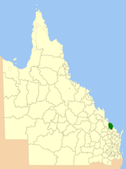
Location within QueenslandPopulation: 4,813 (2001 census) Area: 3800 km² (1,467.2 sq mi) Council Seat: Miriam Vale 
LGAs around Shire of Miriam Vale: Calliope Pacific Ocean Pacific Ocean Calliope Shire of Miriam Vale Pacific Ocean Kolan Kolan Burnett Shire of Miriam Vale is a Local government area near Gladstone in Queensland, Australia. The administrative centre is the town of Miriam Vale.
The Shire of Miriam Vale is renowned as a traditional sheep growing area, and also supports timber, beef and dairy cattle. Tourism is an emerging industry within the Shire and the shire includes the tourist resorts of Agnes Water and the Town of 1770. Other towns in the shire include Lowmead, Rosedale and Bororen.
Local Government Areas of Queensland South East Brisbane · Gold Coast · Ipswich · Lockyer Valley · Logan · Moreton Bay · Redland · Scenic Rim · Somerset · Sunshine CoastWide Bay-Burnett Darling Downs Central Central Highlands · Gladstone · Isaac · Mackay · Rockhampton · WoorabindaNorth Far North Aurukun · Cairns · Cassowary Coast · Cook · Hopevale · Kowanyama · Lockhart River · Mapoon · Napranum · Northern Peninsula Area · Pormpuraaw · Tablelands · Torres · Torres Strait Islands · Weipa · Wujal Wujal · YarrabahNorth West Central West South West Coordinates: 24°19′43″S 151°33′43.4″E / 24.32861°S 151.562056°E
Categories:- Former Local Government Areas of Queensland
- Queensland geography stubs

Wikimedia Foundation. 2010.