- Dalmeny, New South Wales
-
Dalmeny
New South Wales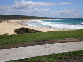
Brou Beach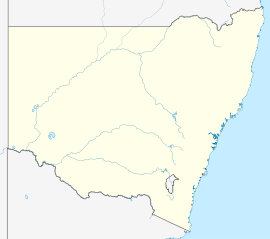
 Dalmeny
Population: 1,928 (2006 census)[1] Postcode: 2546 LGA: Eurobodalla Shire Dalmeny is a town on the south coast of New South Wales, Australia, approximately seven kilometres north of Narooma. At the 2006 census, Dalmeny had a population of 1,928 people.[1]
Dalmeny is a mainly residential area, with the town built upon headlands looking over the Pacific Ocean to the south, and the shore of Lake Mumumga, a coastal lagoon, to the north. Due to its location, Dalmeny is a reasonably popular camping area, with a large camping ground located in the centre of town overlooking the southern end of Brou Beach (commonly called Dalmeny Beach, despite this technically being the next beach south). Despite the town's small and mainly residential nature, the town has a small shopping district in the centre of town, an industrial area to its north-west, and two retirement and aged-care facilities, as well as a bowling club with 4 greens and a small restaurant.
There are many walking and cycling paths through Dalmeny, some along the coastline. Bushwalking is possible in some areas of the Eurobodalla National Park. Dalmeny also has many public boat ramps, picnic spots and lookouts.
Contents
Access
There are two roads which lead into Dalmeny. Mort Avenue leads from the Princes Highway, and Dalmeny Drive leads from Kianga. Both these roads make up Tourist Drive 5, which provides views of Dalmeny's many beaches. There are lots of parking spaces in Dalmeny as well, particularly around Dalmeny Beach. There are also bus routes that run through Dalmeny connecting the town with the rest of the south coast.
Beaches
Dalmeny is best known for its notorious crew the dal boys also known as dalmeny boys and its many beaches, which stretch right around the coastline. Dalmeny (Brou) Beach is the most popular beach, which is on the northern coastline. This beach is patrolled by lifeguards during summer, and is walking distance from shops and the camping ground. Dalmeny (Brou) Beach is great for swimming, surfing and bodyboarding. Dalmeny (Brou) Beach is also part of the Eurobodalla National Park.
Yabbarra Beach is posilbly the best beach on the eastern coast of Dalmeny, and is not patrolled by lifeguards at any time. This beach is more popular with surfers, as the waves here usually stronger than Dalmeny Beach. Yabbarra Beach also has many rocks to the side of the beach, which can pose a danger during rips.
There are more beaches in Kianga, Narooma and Mystery Bay.
Shopping
 Shops in Dalmeny
 Dalmeny IGA and Shell Service station
Dalmeny has a small shopping complex across from Dalmeny Beach. On one corner is an IGA supermarket and a Shell service station. On the other corner is a newsagent, lighting store, carpet store and cafe. More shops are located in the nearby larger centre Narooma, including a Woolworths supermarket.
Notes
- ^ a b Australian Bureau of Statistics (25 October 2007). "Dalmeny (Urban Centre/Locality)". 2006 Census QuickStats. http://www.censusdata.abs.gov.au/ABSNavigation/prenav/LocationSearch?collection=Census&period=2006&areacode=UCL125400&producttype=QuickStats&breadcrumb=PL&action=401. Retrieved 14 July 2009.
External links
-

Aerial photo from east
South Coast, New South Wales Cities: Townships: Basin View · Batehaven · Batemans Bay · Bawley Point · Bega · Bemboka · Bermagui · Berry · Bodalla · Boydtown · Broulee · Callala Bay · Candelo · Cobargo · Congo · Culburra Beach · Dalmeny · Eden · Greenwell Point · Huskisson · Hyams Beach · Kianga · Kioloa · Lake Conjola · Malua Bay · Manyana · Merimbula · Milton · Mogo · Mollymook · Moruya · Mystery Bay · Narooma · Nelligen · Nerrigundah · Pambula · Pambula Beach · Potato Point · Pyree · Rosedale · Sanctuary Point · South Durras · St Georges Basin · Tathra · Tilba · Towamba · Tura Beach · Tuross Head · Ulladulla · Vincentia · Wandandian · Wolumla · WonboynLocal Government Areas: National Parks: Ben Boyd · Bournda · Biamanga · Budawang · Clyde River · Conjola · Deua · Eurobodalla · Gulaga · Jerrawangala · Kooraban · Mimosa Rocks · Monga · Morton · Mount Imlay · Murramarang · South East Forest · WadbilligaCoordinates: 36°10′16″S 150°07′53″E / 36.171033°S 150.131424°E
Categories:- Towns in New South Wales
- Towns in the South Coast, New South Wales


Wikimedia Foundation. 2010.