- Adel, Leeds
-
Coordinates: 53°50′56″N 1°35′06″W / 53.8489°N 1.5849°W
Adel 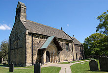
Adel Church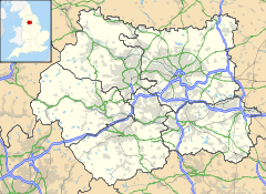
 Adel
Adel
Adel shown within West YorkshireMetropolitan borough City of Leeds Metropolitan county West Yorkshire Region Yorkshire and the Humber Country England Sovereign state United Kingdom Post town LEEDS Postcode district LS16 Dialling code 0113 Police West Yorkshire Fire West Yorkshire Ambulance Yorkshire EU Parliament Yorkshire and the Humber UK Parliament Leeds North West List of places: UK • England • Yorkshire Adel is a suburb in North Leeds, West Yorkshire, England. It is situated between Cookridge, Holt Park, Weetwood and Alwoodley. To the north are the villages of Arthington and Bramhope and the market town of Otley. In common with many areas of Leeds it is not easy to define the boundaries of Adel, but Adel Church and the two schools are well to the east of Otley Road, the A660, although the post office is on that road. There is one pub in Adel and there is a restaurant/pub on the Otley Road around the corner from Gainsborough Avenue(Adel).
Contents
History
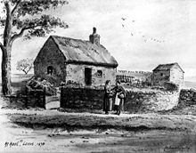 Drawing of Adel by W. Braithwaite in 1878.
Adel is situated near the site of a Roman fort, the ancient road from Tadcaster to Ilkley passing nearby. (The footpath by the side of Long Causeway was said to be made from the original Roman stones, until they were removed by the council in the 1960s because they were unsafe. Some of the footpath has been replaced, starting at the junction between Long Causeway and Stairfoot Lane, and continuing up to the entrance of Bedquilts playing fields.)
The Roman name for the area was Burgodunum. It is probable that a Saxon village sprang up around the fort and that a church was been built in the village. Adel is mentioned in the 1086 Domesday Book as Adele. Another spelling used until 1816 is Addle. They derive from the Old English adela ‘dirty, muddy place’.[1]
The parish of Adel stretched to the River Wharfe in the north and included Adel, Arthington, Breary, Cookridge and Eccup.
In 1152 the nearby Cistercian abbey at Kirkstall was founded. At the same time, the church of St John the Baptist was built in Adel to replace the older Saxon building.
Adel Church
The Church of St John the Baptist, Adel parish church, is described as "one of the best and most complete Norman churches in Yorkshire".[2] It is a grade I listed building; the sundial, mounting block and several memorials are grade II listed.
It was built 1150-1170 and has been little altered since, although a bell-cote was added in 1838-39 by R. D. Chantrell. The doorway, protected by a modern wooden roof, has an ornately carved arch; inside, there are 81 decorative corbels on the north and south walls, and the chancel arch has 37 grotesque beakheads. The medieval font has an oak canopy by Eric Gill, and a leper's window survives in the chancel.
The doorknocker of Adel Church is a replica, as the original has been stolen. Because of thefts of stones from the graveyard, all the church's paving stones are engraved with crosses.
The paternal grandparents of The Duchess of Cambridge married at Adel Church in December 1946.[3]
Adel today
 Adel Crags - rocky outcropping
Adel is a mainly residential area of Leeds close to Adel Crags and the Meanwood Valley Trail and has a distinctive countryside feel. Adel also has two primary schools, St John the Baptist Primary School and Adel Primary School.
Adel is within the Adel and Wharfedale ward of Leeds City Council and the Leeds North West parliamentary constituency.
Close to Adel Church is York Gate, an old farmhouse with a landscaped garden and a pavement maze in the driveway. The gardens are open to the public on regular occasions.
Also close to the church is the Adel Memorial Hall and sports ground. The hall was opened on 14 November 1928 as a memorial to those killed in WW1. The engraved 20 ton stone outside the hall was moved from Adel Moor in May 1922 and erected on the site of the then future hall. The hall is home to the Bowmen of Adel, who hosted the Scorton Arrow in 1962, 1967 and 1970. Adel is home to Headingley Golf club, the oldest golf club in Leeds.
Just to the west is the University of Leeds sports grounds and Bodington Hall, the university's largest hall of residence.
Adel is linked to Leeds city centre by buses, including the 28, operated by First Group.
Asda in Holt Park is incorrectly called 'Asda at Adel', perhaps because, although geographically incorrect, the term Adel is a historical term that can be traced back many centuries, where as the term 'Holt Park' does not predate the area itself.
Location grid

Bramhope Cookridge 
Alwoodley  Adel, Leeds

Meanwood References
- ^ Mills, A. D. (2003). Dictionary of British Place-Names. Oxford University Press. ISBN 0198527586.
- ^ Wrathmell, Susan; John Minnis (2005). Leeds. Pevsner architectural guides. Yale U.P.. p. 268. ISBN 0300107366.
- ^ Reitwiesner, William Addams; Michael J. Wood. "The Ancestry of Kate Middleton". wargs.com. http://www.wargs.com/other/middleton.html. Retrieved 2010-11-17.
External links
- Adel Association Website, local information
- Adel Crag Community Association website, local information
- St John's church website
- Yorkgate garden website
- Corpus of Romanesque Sculpture in Britain and Ireland scholarly description of church carvings including many detailed photographs
- Details from listed building database (465832) - church, grade I listed. Images of England. English Heritage.
- Details from listed building database (465838) - sundial, grade II listed. Images of England. English Heritage.
- Details from listed building database (465852) - mounting block, grade II listed. Images of England. English Heritage.
- Details from listed building database (465851) - memorial to Zinai Wormald, grade II listed. Images of England. English Heritage.
- Details from listed building database (465842) - memorial to Audus Hirst, grade II listed. Images of England. English Heritage.
- Details from listed building database (465848) - memorial to Eliza and William Hill, grade II listed. Images of England. English Heritage.
- The Ancient Parish of Adel at GENUKI
- Leodis View photographs of Adel on the Leeds photographic archive.
Leeds Topics Culture Places List of towns, villages, areas and suburbsGovernment City of Leeds • Leeds City CouncilPeople Categories:- Places in Leeds
- Grade I listed churches
- Listed buildings in Leeds


Wikimedia Foundation. 2010.