Ogwr

Ogwr
Ogwr
WalesOgwr1974.png
Geography
Status Borough
HQ Bridgend
History
Created 1974
Abolished 1996
Succeeded by Bridgend County Borough
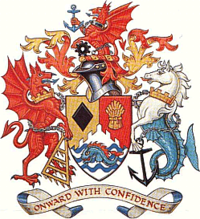
Arms of Ogwr Borough Council

The Borough of Ogwr was one of six districts of Mid Glamorgan in Wales, which existed from 1974 to 1996.

It was formed under the Local Government Act 1972 from the urban districts of Bridgend, Maesteg, Ogmore and Garw and Porthcawl, along with Penybont Rural District from the administrative county of Glamorgan. In 1996 most of Ogwr became part of Bridgend County Borough, with the Vale of Glamorgan taking the communities of Wick, St Brides Major and Ewenny.

The district took its name from the local River Ogwr.

Coordinates: 51°30′31″N 3°34′42″W / 51.5087°N 3.5782°W / 51.5087; -3.5782


Wikimedia Foundation. 2010.

Игры ⚽ Нужен реферат?

Look at other dictionaries:

  • OGwR — Obergewerberat EN senior trade councillor …   Abkürzungen und Akronyme in der deutschsprachigen Presse Gebrauchtwagen

  • Pen-y-Bont Ar Ogwr — Sp Bridžendas Ap Bridgend angliškai Ap Pen y Bont Ar Ogwr vališkai L Velso mst. ir grafystė, Jungtinė Karalystė …   Pasaulio vietovardžiai. Internetinė duomenų bazė

  • River Ogmore — Coordinates: 51°28′11″N 3°38′18″W / 51.46972°N 3.63833°W / 51.46972; 3.63833 …   Wikipedia

  • Ogmore (UK Parliament constituency) — Not to be confused with Ogmore (Assembly constituency). Ogmore County constituency for the House of Commons …   Wikipedia

  • Bridgend County Borough — Bwrdeisdref Sirol Pen y bont ar Ogwr Geography Area Total  % Water Ranked 17th 246 km² …   Wikipedia

  • Mid Glamorgan — Coordinates: 51°48′58″N 3°22′05″W / 51.816°N 3.368°W / 51.816; 3.368 …   Wikipedia

  • Bridgend (county borough) — Bridgend (Welsh: Pen y bont ar Ogwr ) is a county borough in Glamorgan, southern Wales. The county borough has a total population of 130,000 people, and contains the settlements of Bridgend, after which it is named, Maesteg, and the seaside town… …   Wikipedia

  • List of rivers of Wales — This is a list of rivers of Wales, organised geographically, taken anti clockwise, from Hoylake on Wirral through to the M48 Bridge that separates the estuary of the River Wye from the River Severn. Tributaries are listed down the page in an… …   Wikipedia

  • Bridgend — County Borough Verwaltungssitz Bridgend (Stadt) Fläche 246 km² Einwohner 134.200[1] (2009) …   Deutsch Wikipedia

  • Ogmore (Assembly constituency) — Not to be confused with Ogmore (UK Parliament constituency). Ogmore (Welsh: Ogwr) Welsh Assembly county constituency Ogmore shown as one of the 40 Welsh Assembly constituencies …   Wikipedia

Share the article and excerpts

Direct link
Do a right-click on the link above
and select “Copy Link”