- London Borough of Newham
-
"Newham" redirects here. For other uses, see Newham (disambiguation).
London Borough of Newham — London borough — 
Coat of arms
Council logoNewham shown within Greater London
Sovereign state United Kingdom Constituent country England Region London Ceremonial county Greater London Status London borough Admin HQ East Ham Incorporated 1 April 1965 Government - Type London borough council - Body Newham London Borough Council - Leadership Mayor & Cabinet (Labour) - Executive mayor Sir Robin Wales - MPs Lyn Brown
Stephen Timms- London Assembly John Biggs AM for City and East - EU Parliament London Area - Total 14 sq mi (36.22 km2) Area rank 298th (of 326) Population (2010 est.) - Total 240,100 - Rank 55th (of 326) - Density 17,168.9/sq mi (6,628.9/km2) - Ethnicity[1] 32.6% White British
1.1% White Irish
5.4% Other White
1.2% White & Black Caribbean
0.8% White & Black African
0.8% White & Asian
0.9% Other Mixed
12.1% Indian
8.7% Pakistani
9.0% Bangladeshi
12.7% Other Asian
6.7% Black Caribbean
12.7% Black African
1.1% Other Black
1.4% Chinese
2.4% OtherTime zone GMT (UTC0) - Summer (DST) BST (UTC+1) Postcodes E , IG Police force Metropolitan Police Website newham.gov.uk The London Borough of Newham
 i/ˈnjuːəm/ is a London borough formed from the towns of West Ham and East Ham, within eastern Greater London.
It is situated 5 miles (8 km) east of the City of London, and is north of the River Thames. According to 2006 estimates, Newham has one of the highest ethnic minority populations of all the districts in the country, with no particular ethnic group dominating. The local authority is Newham London Borough Council.
Contents
History
The borough was formed by merging the former area of the Essex county borough of East Ham and the county borough of West Ham as a borough of the newly formed Greater London, on 1 April 1965. Green Street marks the former boundary between the two. North Woolwich also became part of the borough (previously being in the Metropolitan Borough of Woolwich, in the County of London) along with a small area west of the River Roding which had previously been part of the Municipal Borough of Barking. Newham was devised for the borough as an entirely new name.[2]
Governance
Unlike most English districts, its council is led by a directly elected mayor of Newham. From 2002 to 2009 one of the councillors had been appointed as the "civic ambassador" and performed the civic and ceremonial role previously carried out by the mayor. The post was discontinued.[3]
Although statistically counted as part of Inner London, the borough is still considered part of Outer London for purposes such as funding. This is because the majority of Newham was not part of the 1889-1965 County of London. However, much of the borough has historically formed part of London's built-up area and economically it is one of the more deprived districts. The council is actively campaigning to have Newham officially considered part of Inner London for all purposes in order to increase its level of government grant by £60 million. Newham is a challenging borough in a number of ways and currently has the second lowest recycling rate in the United Kingdom.[4]
At the borough elections held on 6 May 2010 the Labour Party won all 60 of the seats on the Council. Sir Robin Wales was re-elected as the borough's Executive Mayor with 68% of the first preference votes cast.
Demography
Population Year Pop. ±% 1801 8,875 — 1811 11,166 +25.8% 1821 13,005 +16.5% 1831 15,553 +19.6% 1841 17,758 +14.2% 1851 24,875 +40.1% 1861 69,355 +178.8% 1871 113,835 +64.1% 1881 158,314 +39.1% 1891 259,155 +63.7% 1901 338,506 +30.6% 1911 442,158 +30.6% 1921 448,081 +1.3% 1931 454,096 +1.3% 1941 377,508 −16.9% 1951 313,837 −16.9% 1961 271,858 −13.4% 1971 235,496 −13.4% 1981 209,131 −11.2% 1991 221,146 +5.7% 2001 243,737 +10.2% Source: A Vision of Britain through time, citing Census population Newham has the highest young population and one of the lowest White British populations in the country according to the 2001 Census. The borough has the second highest percentage of Muslims in Britain (24.3%).
When using Simpson's Diversity Index on 10 aggregated ethnic groups, the 2001 census identified Newham as the most ethnically diverse district in England and Wales, with 9 wards in the top 15.[5] However, when using the 16 ethnic categories in the Census so that White Irish and White Other ethnic minorities are also included in the analysis, Newham becomes the 2nd most ethnically diverse borough[6] with 6 out of the top 15 wards, behind Brent with 7 out of the top 15 wards.
The main ethnic groups are whites and Asians. Based on 2006 estimates by the Office for National Statistics, over 39% of the population is white, of which 32.6% are British, 1.1% are Irish, and 5% are from other white backgrounds. Approximately 38% of the population is Asian, of which 10.2% are Indian, 7% are Bangladeshi, 13.9% are Pakistani, and 5.1% are from other Asian backgrounds. Approximately 20% of the population is black, of which 6.5% are Caribbean, 12.4% are African, and 1.1% are from other black backgrounds. In addition, 1.6% of the population is Chinese, and 2.6% are from other ethnic groups.[7] Newham has the highest fertility rate in the country at 2.87, as of 2009, compared to the national average of 1.95.[8]
Notable local residents
- Actor Perry Fenwick, who has played Billy Mitchell in EastEnders from 1998
- Actor Billy Murray, who has played Don Beech in The Bill, Johnny Allen in EastEnders and Captain Price in Call Of Duty 4 and Modern Warfare 2
- 1960s model Celia Hammond
- Singer Vanessa White - Member of girl band The Saturdays
- Actor and professional Cockney Danny Dyer, who has appeared in films including Human Traffic and The Football Factory
- Rapper Plan B
- Actress Carol Harrison who played Louise Raymond in EastEnders during the late 1990s
- Athlete Christine Ohuruogu
- Basketball paralympian and TV presenter Ade Adepitan
- Actor Idris Elba, star of The Wire and Obsessed
- Actor, Jimmy Akingbola
- Singer and actor, David Essex
- Scriptwriter Johnny Speight
- Athlete, Mohammed Farah
- Footballer, Dennis Oli
- Footballer, Jermain Defoe
- Footballer, Sol Campbell
- Footballer, Mark Noble
- Rapper BlazeMan
- Comedienne, Andi Osho
- Karate Athlete, Molly Samuels (7 times World Champion)
- Bond girl, Honor Blackman
- Rapper Ghetto
- Singer, and member of Sugababes, Jade Ewen
- TJ's, Melissa Apples, Zac
- Rapper, Singer-songwriter Mumzy Stranger
- Page 3 Model, Peta Todd
Education
Schools and colleges
Main article: List of schools in the London Borough of NewhamThe Borough is the education authority for the district providing education in a mix of Foundation, community and voluntary aided schools.[9] The borough also owns and operates Debden House, a residential adult education college in Loughton, Essex. The Essex Primary School in Sheridan Road with over 900 pupils is one of the biggest primary schools in London.
University
The University of East London has two campuses in Newham:
- the Stratford Campus, at Stratford
- the Docklands Campus, next to the regenerated Royal Albert Dock
Birkbeck Stratford is a collaboration between Birkbeck, University of London and UEL to increase participation in adult learning. This is currently based on the UEL Stratford campus, but is planned to move to its own facilities.
The University of East London has formed a partnership with the United States Olympic Committee which will result in the United States Olympic Team using University of East London campuses as training bases during the London 2012 Olympic and Paralympic Games.[10]
Places of interest
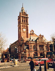 Newham Town Hall in East Ham (E6)
Community
- The Hub, a community resource centre built by the local community, in Star Lane, E16, featuring up to the minute "green" features
- Grassroots, also built by the local community and another innovative green resource centre built by the community. Grassroots is in Memorial Recreation Ground, E15
Libraries
Newham has ten libraries (Beckton, Canning Town, Custom House, East Ham, Green Street, Manor Park, North Woolwich, Plaistow, Stratford and Forest Gate) and a mobile library.
Canning Town Library was first opened in 1893 and still operates in the original building on Barking Road (albeit with repairs and a reconstructed interior following damage from air raids in 1940 and 1941). Its opening hours are Monday, Tuesday and Saturday: 9:30am–5:30pm, Wednesday and Sunday: Closed, Thursday-Friday: 7:00am–6:00pm.[11]
Museums
- North Woolwich Old Station Museum
- Three Mills, a mill complex on the east bank of the River Lee. A trading site for nearly a thousand years, the House Mill was built in 1776 and was (and remains) the country's largest tide mill. It has been restored and contains much of its original machinery including four large waterwheels, millstones and grain chutes.
Markets
There are a number of local markets in the Borough, including Queens Market, which the Council is controversially seeking to redevelop. These proposals are being fought by Friends of Queens Market.
Parks and open spaces
Main article: Newham parks and open spaces80 hectares within the borough are designated as part of the Metropolitan Green Belt.
Performance
 Green Street where the population is predominantly South Asian
- St. Mark's Church, Silvertown The church was designed by Samuel Saunders Teulon. It was built between 1861 and 1862 after a cholera epidemic swept the district and local clergy appealed through the columns of The Times for funds to provide an architectural, as well as spiritual, beacon for the area. It is now the home of the Brick Lane Music Hall.
- Stratford Circus
- Theatre Royal Stratford East
Shopping and exhibitions
- Queen's Market, Upton Park - London's most lively and ethnically diverse market
- ExCeL Exhibition Centre- major exhibitions such as the Motor Show are now held at ExCeL
- ICC London - ExCel - London's new International Conference Centre which opened on 1 May 2010
- Gallions Reach Shopping Park Out of town retail park
- Green Street, the largest shopping centre catering for the Asian community in London[12]
- Stratford Shopping Centre, a shopping centre which includes a small market and typical chainstores
- Westfield Shopping Centre, Stratford The largest Westfields in Europe. Opened in September 2011.
Sport
- Newham is one of the six host boroughs for the 2012 Summer Olympics. As a result it has been undergoing major upheavals, especially in the north of the borough, which are anticipated to end around 2016. The borough hopes to gain many advantages for its residents during that period. At the same time the new Westfield Shopping Centre, next to the Olympic Village, will have an even greater effect on the borough when it is completed well before the Olympics in 2011
- West Ham United F.C. is at Upton Park
Newspapers
The local newspaper is the Newham Recorder[13] and is edited by Colin Grainger.
Districts
 Logo on the roadside at sunset
 Building 1000 - Newham Council Headquarters
- Beckton
- Canning Town
- Custom House
- Cyprus
- East Ham
- Forest Gate
- Little Ilford
- Manor Park
- Maryland
- Mill Meads
- North Woolwich (/ˈwʊlɪtʃ/ or /ˈwʊlɪdʒ/)
- Plaistow /ˈplɑːstoʊ/
- Plashet
- Silvertown
- Stratford
- Stratford Marsh
- Stratford New Town
- Temple Mills
- Upton
- Upton Park
- Wallend
- West Ham
Transport
Transport in Newham is undergoing a major upgrade, with the completed Docklands Light Railway and Jubilee Line Extension, with new or improved stations at Canning Town, West Ham and Stratford. Stratford International station on High Speed 1 opened in late 2009. The Crossrail scheme will also improve rail connections to several stations in the borough. The Docklands Light Railway was extended to serve London City Airport.
List of stations
- Beckton DLR station
- Beckton Park DLR station
- Cyprus DLR station
- Canning Town station - Jubilee Line and DLR
- Custom House station - DLR
- East Ham tube station - District and Hammersmith & City Lines
- Forest Gate railway station - National Express
- Gallions Reach DLR station
- King George V DLR station
- London City Airport DLR station
- Manor Park railway station - National Express
- Maryland railway station - National Express
- Plaistow tube station - District and Hammersmith & City Lines
- Pontoon Dock DLR station
- Prince Regent DLR station
- Royal Albert DLR station
- Royal Victoria DLR station
- Stratford station - National Express, c2c, Jubilee Line, Central Line, London Overground and DLR
- Stratford International station - Southeastern, Eurostar (from mid-2010), DLR (from mid-2010)
- Pudding Mill Lane DLR station
- Upton Park tube station - District and Hammersmith & City Lines
- Wanstead Park railway station - London Overground
- West Ham station - c2c, Jubilee, District and Hammersmith & City Lines
- West Silvertown DLR station
- Woodgrange Park railway station - London Overground
International services
- Dutchflyer rail-sea service via Stratford station
- London City Airport
- Stratford International station (Eurostar, from mid-2010)
Bus routes
London Buses routes 5, 25, 58, 69, 86, 101, 104, 108, 115, 147, 158, 173, 238, 241, 257, 262, 276, 300, 308, 309, 323, 325, 330, 366, 376, 425, 473, 474, 488, D8, W19, School buses route 678 and Night route N8, N15, N86, N550 and N551.
See also
- List of districts in Newham
- Newham parks and open spaces
- Newham Sixth Form College
- Newham College of Further Education
- Stratford Circus
- Stratford, London
- Stratford City
- Thames Gateway
- Rising East
References and notes
- ^ Data Management and Analysis Group, Greater London Authority, Demography Update October 2007, (2007)
- ^ Mills, A. Oxford Dictionary of London Place Names, (2001)
- ^ The Civic Ambassador London Borough of Newham, accessed 13 December 2006
- ^ Other Stories we Liked, The Times. 22 November 2005.
- ^ Simpson's diversity indices by ward 1991 and 2001 - GLA Data Management and Analysis Group (page 11, Table 3) Greater London Authority, January 2006), accessed 13 December 2006
- ^ Focus on Newham 2006 - local people and local conditions - London Borough of Newham, Corporate Research Unit (chapter 2, page 24) (2006) date accessed 31 March 2007
- ^ "Ethnic Group (Jun 06)". Neigbourhood Statistics 2006 estimates. Office for National Statistics. http://www.neighbourhood.statistics.gov.uk/dissemination/LeadTableView.do?a=7&b=276767&c=E6+1LA&d=13&e=13&g=343065&i=1001x1003x1004&o=1&m=0&r=0&s=1237988258800&enc=1&dsFamilyId=1812. Retrieved 31 May 2008.
- ^ Stoddard, Katy (25 May 2010). "Birth statistics: Birth and fertility rates across England and Wales". The Guardian (London). http://www.guardian.co.uk/news/datablog/2010/may/25/birth-rate-statistics-england-wales.
- ^ Education and Learning London Borough of Newham, accessed 24 March 2008
- ^ "University of East London Olympic Partnerships". http://www.uel.ac.uk/2012/office/partners.htm.
- ^ Cherry, Bridget et al. London 5: East: the Buildings of England, New Haven: Yale University Press, 2005
- ^ Green Street London E7
- ^ Newham news, sport, leisure, property, jobs and motors Newham Recorder
External links
- Newham London Borough Council
- Mayor of Newham
- NIMS - Statistics on Newham
- Newham Issues Forum - online local discussions
- Aston-Mansfield- charity started in 1884
- Community Links - innovative charity running community-based projects
- Newham Labour Party - website of the Labour Party in Newham
- Rising East: the journal of East London studies
- Newham Story - memories of Newham
- Local guide to Stratford, Newham
Governance of Greater London Regional London boroughs - Barking and Dagenham
- Barnet
- Bexley
- Brent
- Bromley
- Camden
- Croydon
- Ealing
- Enfield
- Greenwich
- Hackney
- Hammersmith and Fulham
- Haringey
- Harrow
- Havering
- Hillingdon
- Hounslow
- Islington
- Kensington and Chelsea
- Kingston upon Thames
- Lambeth
- Lewisham
- Merton
- Newham
- Redbridge
- Richmond upon Thames
- Southwark
- Sutton
- Tower Hamlets
- Waltham Forest
- Wandsworth
- Westminster
Ceremonial Historical - Metropolitan Board of Works (MBW) 1855–1889
- London County Council (LCC) 1889–1965
- Greater London Council (GLC) 1965–1986
- Leaders
Categories:- London boroughs
- Local authorities adjoining the River Thames
- London Borough of Newham
- UK locations with ethnic minority-majority populations
- 1965 establishments in the United Kingdom


Wikimedia Foundation. 2010.