- Monsal Trail
-
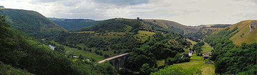 Viewed from Monsal Head, the Monsal Trail passes over Headstone Viaduct, and then on towards Millers Dale
 Cressbrook Tunnel, one of four re-opened to the public in May 2011
The Monsal Trail is a cycle, horse riding and walking trail in the Derbyshire Peak District.Contents
Route description
It follows a section of the former Manchester, Buxton, Matlock and Midlands Junction Railway, built by the Midland Railway in 1863 to link Manchester with London. The line was closed in 1968 by the Labour Minister for Transport Barbara Castle, not as it is often thought by the Beeching Axe, and remained unused for twelve years before being taken over by the Peak District National Park.
The Monsal Trail is about 8.5 miles (13.7 km) in length.[3] It starts at the Topley Pike junction (in Wye Dale, 3 miles (4.8 km) east of Buxton) and runs to Coombs viaduct, 1 mile (1.6 km) south-east of Bakewell. It follows the valley of the River Wye and runs parallel to the A6.
From the Wyedale car park,[4] the easiest access point for the northern end of the trail, there is a walk of about 1 kilometre (0.62 mi), with the last part up steps, to reach the Trail.[5] Starting at the south of the trail, "from Market Place in Bakewell, follow Sheffield Road and cross the five-arched bridge of the River Wye, turn right and ascend Station Road to the former Bakewell Station and car park on your left."[6]
 The Monsal Trail as it passes the former Great Longstone Station
The trail passes through such places as Blackwell Mill, Millers Dale, Cressbrook, Monsal Dale, Great Longstone, Hassop and Bakewell. In the case of Longstone and Hassop, although a station was provided, it was some distance from the village.
This route through the Wye valley was necessitated by the Duke of Devonshire's objection to the railway passing through his grounds (which included not only Chatsworth House, but extensive grounds north of Rowsley). This route meant, for instance, that the line had to pass above the town of Bakewell, rather than through it.
The Duke of Rutland, of Haddon Hall, insisted on the construction of Haddon Tunnel to hide it from his view, but he used Bakewell station, which was built to a grander design than normal, and carried his coat of arms.
The Duke of Devonshire later came to realise the value of the railway, and his offer for the Midland Railway to run through Chatsworth came too late. He was therefore the force behind the construction of Hassop station, which, although nearer to Bakewell than Hassop village itself, meant that he did not have to share a station with his neighbour, the Duke of Rutland.[7]
Great Longstone (simply called 'Longstone' before 1913) served Thornbridge Hall, and the station design, with leaded glass windows, reflected the architecture of the hall itself.
For many years the Trail could not follow the trackbed at all times, for where tunnels had been closed for safety reasons, such as at Monsal Head and Cressbrook, the path was locally diverted (but were walked by Julia Bradbury in the BBC tv's Railway Walks: The Peak Express).[8] Many of these access points and paths diverting around the closed tunnels were unsuitable for those using cycles, in wheelchairs or with difficulty walking, as they had steep uneven stone steps or narrow paths. Plans to make the tunnels safe and re-open them to the public were given the go-ahead at a cost of £3.785m,[9] and the tunnels were opened officially for use on 25 May 2011 at a ceremony at the Headstone Viaduct though in practice they have been open for use since Friday 13 May 2011. As a consequence, the whole Trail is now virtually level (though the former diversions are still useable, if desired), and can therefore even be used by wheelchair users with level access onto the trail at Bakewell, Hassop Station (disabled toilet at Hassop Station) and Millers Dale.
 Route map before the reopening of the tunnels
The notorious Litton Mill, downstream from Millers Dale station, is where orphans from major cities were abused by Ellis Needham, with the graves of many to be found in local churchyards. William Newton's 1783 Cressbrook Mill (on the site of a herb distillery) was used by Richard Arkwright.[10]
It is hoped by Pedal Peak District, the organization behind the funding of the reopening of the tunnels, that it will be possible at some future point to extend the Trail to create a circular route linking Buxton, Matlock and Bakewell.[11]
Several miles to the south and south-west of this trail lie two other cycle/horse riding/walking trails, which similarly utilize former railway trackbeds, namely the High Peak Trail and the Tissington Trail.
Headstone Viaduct
Headstone Viaduct, at Monsal Head, is one of the more impressive structures on the line, although when it was built it was seen as destroying the beauty of the dale. John Ruskin, a poet and conservationist of the time, criticized the folly of building the railway:
“ The valley is gone - and now every fool in Buxton can be in Bakewell in half an hour and every fool at Bakewell in Buxton. ” His words are displayed on the viaduct. However, when the railway closed and there was talk of demolishing the viaduct, there was considerable opposition. In 1970 a preservation order was placed on the structure.
Equally impressive, though less easily viewed, are the twin viaducts at Millers Dale, where a branch line ran to Buxton. The Trail runs across the older of the two.
See also
References
- ^ "Monsal Trail Derbyshire Peak District Litton Cressbrook Mill Cycling Bike Track Disused Railway". http://www.thepeakdistrict.info/monsal_trail.php. Retrieved 2009-04-21.
- ^ "Monsal Trail structures". http://www.forgottenrelics.co.uk/bridges/monsal.html. Retrieved 2010-04-17.
- ^ "Peak District View : Monsal Trail". http://www.peakdistrictview.com/?page=place&placeid=830. Retrieved 2009-04-21.
- ^ Access page on PeakDistrict.org
- ^ Cheedale page on Cressbrook.co.uk
- ^ "Monsal Trail Walk". http://www.peakdistrictonline.co.uk/content.php?categoryId=1189. Retrieved 2011-01-16.
- ^ Railways in the Peak District, by Nicholson & Barnes, Dalesman Books 1971
- ^ "BBC - BBC Four Programmes - Railway Walks, The Peak Express". http://www.bbc.co.uk/programmes/b00dtp4b. Retrieved 2009-04-18.)
- ^ "BBC News - Go-ahead for reopening of tunnels". http://news.bbc.co.uk/1/hi/england/derbyshire/8383152.stm. Retrieved 2009-12-21}.
- ^ "Monsal Trail in Derbyshire and the Peak District". http://www.derbyshireuk.net/monsal_trail.html. Retrieved 2009-04-21.
- ^ Sheffield Telegraph
External links
- National Park Authority website - The Monsal Trail
- "Discover Derbyshire and the Peak District - MONSAL TRAIL". http://derbyshire-peakdistrict-co-uk.leia.parcomweb.net/monsaltrail.htm. Retrieved 2009-04-21.
- "The Monsal Trail is a Peak District cycle trail". http://www.cressbrook.co.uk/visits/monsaltrail.php. Retrieved 2009-04-21.
- "Monsal Trail Walk,walking the monsal trail,walking in derbyshire,monsal trail,derbyshire walking,". http://www.peakdistrictonline.co.uk/content.php?categoryId=1189. Retrieved 2009-04-21.
- "The Monsal Trail - in the White Peak. (Tom Bates Derbyshire Peak District Author, Writer, Poet)". http://www.aboutderbyshire.co.uk/cms/9/the-monsal-trail.shtml. Retrieved 2009-04-21.
- "Chee Dale and Monsal Trail Map and Elevation Profile". http://www.sharemyroutes.com/routes/United-Kingdom/Millers-Dale-Derbyshire-England/Chee-Dale-and-Monsal-Trail/elevationmap.aspx. Retrieved 2009-04-21.
Categories:- Peak District
- Rail trails in England


Wikimedia Foundation. 2010.