- National Highway 24 (India)
-
National Highway 24

24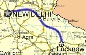
Road map of India with National Highway 24 highlighted in solid blue colorRoute information Length: 438 km (272 mi) Major junctions North end: Delhi South end: Lucknow, Uttar Pradesh Location States: Delhi: 7 km (4.3 mi)
Uttar Pradesh: 431 km (268 mi)Primary
destinations:Delhi, Ghaziabad, Moradabad, Bareilly, Shahjahanpur, Sitapur, Lucknow Highway system Indian Road Network
National • Expressways • State
State Highways in ¬← NH 23 NH 24A → National Highway 24 or NH 24 is a National Highway in India that connects the National capital Delhi to Uttar Pradesh state capital Lucknow running 438 km (272 mi) in length. [1]
A part of this highway within Delhi is known as Gurjar Samrat Mihir Bhoja Marg in tribute to the GurjaraPratihara ruler Mihir Bhoja. There is a plan to widen National Highway 24 to eight lanes from UP Gate till Vijay Nagar.
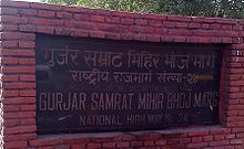 Part of NH-24 is also known as Gurjar Samrat Mihir Bhoj Marg
The work of widening NH-24, passing through Uttar Pradesh, has commenced while the work of four-laning the national highway from the UP-Delhi border to Hapur has been completed, National Highway Development authorities said. According to officials, the work of widening the stretches from Hapur to Moradabad and Sitapur to Lucknow under NHDP are in progress and would be completed by September 2007 and June 2009, respectively. The remaining stretch of the Moradabad-Bareilly-Sitapur section of NH-24, included under NHDP Phase III-B, will also be widened. The DPR for this project is being prepared.Funds to the tune of Rs 82.70 crore have been spent for widening of NH-24 up to February 2007. There are also many projects of residential & commercial properties are in under constructions and many builders are launching new projects near NH 24 like wave city plots. The Road Transport and Highways Ministry has cleared the widening of National Highway-24 starting from Ghaziabad to Dasna near Hapur in Uttar Pradesh involving an investment of Rs. 300 cr. The widening of this road stretch will enable motorists to drive straight to Corbett National Park and Nainital in the Uttrakhand. Similarly, the widening work on the 6km stretch from Nizamuddin Bridge to Ghaziabad is currently in full swing and is expected to be completed this year itself.
The newly cleared 28km stretch is already four lanes road from Ghaziabad border to Dasna and is said to be one of the most congested NH corridors in the country. The completion of the widening process is expected to be completed in about three years after which it will be almost a signal free stretch. The project, which will be widened and there will also be a provision of constructing elevated structures, is being awarded on cash contract and on public private partnership (PPP) model and the ministry is hopeful of awarding it very shortly
References
See also
- List of National Highways in India (by Highway Number)
- National Highways Development Project
Indian Highways Network National Expressways NE 1 • NE 2


State Expressways Mumbai-Pune • Delhi-Gurgaon • DND Flyway • Bengaluru-Mysore • Chennai HSCTC • Hyderabad Elevated ExpresswaysNational Highways 1 • 1A • 1B • 1C • 1D • 2 • 2A • 3 • 4 • 4A • 4B • 5 • 5A • 6 • 7 • 7A • 8 • 8A • 8B • 8C • 8D • 8E • 9 • 10 • 11 • 11A • 11B • 12 • 12A • 13 • 14 • 15 • 16 • 17 • 17A • 17B • 18 • 19 • 20 • 21 • 21A • 22 • 23 • 24 • 24A • 24B • 25 • 25A • 26 • 26A • 27 • 28 • 28A • 28B • 28C • 29 • 30 • 30A • 31 • 31A • 31B • 31C • 31D • 32 • 33 • 34 • 35 • 36 • 37 • 37A • 38 • 39 • 40 • 41 • 42 • 43 • 44 • 44A • 45 • 45A • 45B • 45C • 46 • 47 • 47A • 47B • 47C • 48 • 49 • 50 • 51 • 52 • 52A • 52B • 53 • 54 • 54A • 55 • 56 • 57 • 57A • 58 • 59 • 59A • 60 • 60A • 61 • 62 • 63 • 64 • 65 • 66 • 67 • 68 • 69 • 70 • 71 • 71A • 71B • 72 • 72A • 73 • 73A • 74 • 75 • 76 • 77 • 78 • 79 • 79A • 80 • 81 • 82 • 83 • 84 • 85 • 86 • 86A • 87 • 88 • 89 • 90 • 91 • 91A • 92 • 93 • 94 • 95 • 96 • 97 • 98 • 99 • 100 • 101 • 102 • 103 • 104 • 105 • 106 • 107 • 108 • 109 • 110 • 111 • 112 • 113 • 114 • 116 • 117 • 119 • 121 • 123 • 125 • 126 • 127 • 128 • 129 • 150 • 151 • 152 • 153 • 154 • 155 • 200 • 201 • 202 • 203 • 203A • 204 • 205 • 206 • 207 • 208 • 209 • 210 • 211 • 212 • 213 • 214 • 214A • 215 • 216 • 217 • 218 • 219 • 220 • 221 • 222 • 223 • 224 • 226 • 227 • 228 • 229 • 234 • 235State Highways Andhra Pradesh • Arunachal Pradesh • Assam • Bihar • Chhattisgarh • Goa • Gujarat • Haryana • Himachal Pradesh • Jammu and Kashmir • Jharkhand • Karnataka • Kerala • Madhya Pradesh • Maharashtra • Manipur • Meghalaya • Mizoram • Nagaland • Orissa • Punjab • Rajasthan • Sikkim • Tamil Nadu • Tripura • Uttarakhand • Uttar Pradesh • West BengalNotable Categories:- National Highways in Delhi
- National Highways in Uttar Pradesh
- Indian National Highways
- India road stubs


Wikimedia Foundation. 2010.