- Maryland Route 42
-
Maryland Route 42
Friendsville Road 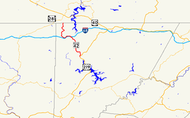
Maryland Route 42 highlighted in redRoute information Maintained by MDSHA Length: 15.06 mi[1] (24.24 km) Major junctions South end:  US 219 in McHenry
 I-68 in Friendsville
North end: PA SR 2013 in Asher Glade Location Counties: Garrett Highway system Maryland highway system
Interstate • US • State • Minor • Former • Turnpikes←  MD 41
MD 41MD 43  →
→Maryland Route 42 (MD 42) is a state highway in the U.S. state of Maryland. Known as Friendsville Road, the state highway runs 15.06 miles (24.24 km) from U.S. Route 219 (US 219) near McHenry north to the Pennsylvania state line in Asher Glade, where the highway continues as State Route 2013 in Fayette County toward Pennsylvania Route 281 (PA 281) in Markleysburg. MD 42 provides the most direct route between Friendsville and southern Garrett County. The state highway was constructed as a modern highway from Friendsville to north of Accident in the early 1920s. The remainder of the highway through Asher Glade was completed in the early 1930s. The southern terminus was shifted from Accident to McHenry in 1960.
Contents
Route description
MD 42 begins at a tangent intersection with US 219 (Garrett Highway) at the northern edge of McHenry near Deep Creek Lake. The state highway heads north as a two-lane road. After meeting Hoyes Sang Run Road in the hamlet of Hoyes, MD 42 curves west then north again through farmland. The state highway features a pull-off for trucks to check their brakes before starting a descent with grades of up to 8%. The uphill direction has a climbing lane for part of the ascent. At the bottom of the hill, MD 42 enters the town of Friendsville and turns west. First Avenue, which is unsigned MD 742, heads north into the center of Friendsville while MD 42 bypasses the town center to the south and west.[1][2]
After crossing the Youghiogheny River, MD 42 turns northwest and meets Interstate 68 (I-68) at a diamond interchange. The entrance ramp from MD 42 to westbound I-68 forms the fourth leg of the intersection with the other end of MD 742, Maple Street, which receives the exit ramp from westbound I-68. MD 42 heads west up a creek valley to an intersection with Blooming Rose Road, then turns north and crosses Buffalo Run. Shortly after crossing Laurel Run and Glade Run, the state highway passes through the unincorporated community of Asher Glade before the highway reaches its northern terminus at the Pennsylvania state line.[1][2] The road continues north as SR 2013 (Friendsville Road) toward Markleysburg, where the highway meets PA 281.[2][3]
History
MD 42 originally connected Friendsville with US 219 north of Accident via Bear Creek Road instead of the current connection near McHenry.[4] The state highway was paved for about 3 miles (4.8 km) east of Friendsville in 1921.[5][6] The highway was complete to present day US 219 at the hamlet of Kaese Mill north of Accident in 1923.[7] The first section of MD 42 from Friendsville to the Pennsylvania state line was completed in 1928 from the west side of the Youghiogheny River to Blooming Rose Road.[8] The modern Maple Street bridge over the Youghiogheny River was built in 1932.[9] Construction of MD 42 from Blooming Rose Road to the state line began in 1932 and was completed in 1935.[10][11]
MD 42 was transferred from its eastern terminus near Accident to a southern terminus near McHenry, following First Street north to Maple Street within Friendsville, in 1960.[12] The state highway originally followed Hoyes Road east from the crossroads in Hoyes to US 219 north of the present terminus.[13] MD 42 was shifted to its present terminus south of Hoyes around 1972.[14] The state highway was relocated in Friendsville to connect with its interchange with I-68 in 1975; First Street and Maple Street through Friendsville were designated MD 742.[15]
Junction list
The entire route is in Garrett County.
Location Mile
[1]Destinations Notes McHenry 0.00 US 219 (Garrett Highway) – Oakland, AccidentSouthern terminus Friendsville 7.27 First Avenue north Unsigned MD 742 7.67 I-68 (National Freeway) – Cumberland, MorgantownI-68 Exit 4 7.83 Maple Street east Unsigned MD 742 Asher Glade 15.06 PA SR 2013 north to  PA 281 – Markleysburg, PA
Northern terminus; Pennsylvania state line 1.000 mi = 1.609 km; 1.000 km = 0.621 mi Auxiliary route
MD 42A is a 0.02-mile (0.032 km) connector between MD 42 and MD 828A near Blooming Rose Road west of Friendsville.[1][16]
References
- ^ a b c d e "Highway Location Reference: Garrett County" (PDF). Maryland State Highway Administration. 2009. http://www.marylandroads.com/Location/2009_GARRETT.pdf. Retrieved 2010-11-01.
- ^ a b c Google, Inc. Google Maps – Maryland Route 42 (Map). Cartography by Google, Inc. http://maps.google.com/maps?f=d&source=s_d&saddr=us+219+and+md-42+mchenry,+md&daddr=Friendsville+Rd%2FNelson+Rd%2FPA-42+N&hl=en&geocode=FTLXWwIdi-RE-ynJQl66V6vKiTGUgHgIHHfFYA%3BFaUZXgIdKMRD-w&mra=ls&sll=39.57298,-79.368346&sspn=0.007592,0.01929&ie=UTF8&t=h&z=11. Retrieved 2010-02-28.
- ^ Pennsylvania Department of Transportation (PDF). General Highway Map: Fayette County, Pennsylvania (Map) (2009 ed.). ftp://ftp.dot.state.pa.us/public/pdf/BPR_pdf_files/Maps/GHS/Roadnames/fayette_GHSN.pdf. Retrieved 2010-02-28.
- ^ Maryland State Roads Commission. General Highway Map: State of Maryland (Map) (1939 ed.).
- ^ Maryland Geological Survey. Map of Maryland: Showing State Road System and State Aid Roads (Map) (1921 ed.).
- ^ "NBI Structure Number: 200000G-0085010". National Bridge Inventory. http://nationalbridges.com/nbi_record.php?StateCode=24&struct=200000G-0085010. Retrieved 2010-11-01.
- ^ Maryland Geological Survey. Map of Maryland: Showing State Road System and State Aid Roads (Map) (1923 ed.).
- ^ Maryland Geological Survey. Map of Maryland: Showing State Road System and State Aid Roads (Map) (1928 ed.).
- ^ "NBI Structure Number: 100000110011010". National Bridge Inventory. http://nationalbridges.com/nbi_record.php?StateCode=24&struct=100000110011010. Retrieved 2010-11-01.
- ^ Report of the State Roads Commission of Maryland. 1931-1934. Baltimore: Maryland State Roads Commission. 1934-12-28. p. 337. http://www.archive.org/details/annualreportsofs1931mary. Retrieved 2010-11-01.
- ^ Maryland Geological Survey. Map of Maryland Showing State Road System: State Aid Roads and Improved County Road Connections (Map) (1935 ed.).
- ^ Maryland State Roads Commission. Maryland: Official Highway Map (Map) (1960 ed.).
- ^ Maryland State Roads Commission. Maryland: Official Highway Map (Map) (1963 ed.).
- ^ Maryland State Highway Administration. Maryland: Official Highway Map (Map) (1972 ed.).
- ^ Maryland State Highway Administration. Maryland: Official Highway Map (Map) (1975-76 ed.).
- ^ Google, Inc. Google Maps – Maryland Route 42A (Map). Cartography by Google, Inc. http://maps.google.com/maps?f=d&source=s_d&saddr=MD-42+S%2FFriendsville+Rd&daddr=Unknown+road&hl=en&geocode=FbAdXQIdKOlD-w%3BFbYcXQIdkelD-w&mra=ls&sll=39.656654,-79.435042&sspn=0.001896,0.004823&ie=UTF8&ll=39.656751,-79.435548&spn=0.000948,0.002411&t=h&z=19. Retrieved 2010-11-02.
External links
Roads in Garrett County, Maryland State highways 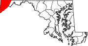
U.S. Highways Interstate Highways Categories:- State highways in Maryland
- Roads in Garrett County, Maryland


Wikimedia Foundation. 2010.