- Cotton Gin Port, Mississippi
-
Cotton Gin Port Site
Nearest city: Amory, Mississippi Area: 100 acres (40 ha) Governing body: Private NRHP Reference#: 72000700[1] Added to NRHP: October 18, 1972 Cotton Gin Port is a ghost town in Monroe County, Mississippi, United States.
Contents
Geography
Cotton Gin Port was located at 33°58′15″N 88°32′35″W / 33.97083°N 88.54306°W on the east bank of the Tombigbee river.
History
Cotton Gin Port was the first town in north Mississippi. It was located on the east bank of the Tombigbee River at a crossing of vital Indian trails. It was a base of expeditions of Jean-Baptiste Le Moyne de Bienville in 1736 and Vaudreuil in 1752. The Kansas City, Memphis & Birmingham Railroad caused extinction as the townfolk moved to the new town of Amory.
The early U.S. government built a cotton gin in 1801 at Cotton Gin Port as part of a "plan of civilization" for the local Chickasaw Indians. A road, Gaines Trace, was built to the town in 1811 and 1812. This road ran from close to Muscle Shoals on the Tennessee River to Cotton Gin Port, where it crossed the Tombigbee; it then proceeded south to Fort Stoddert.
The ruins of the old town can still be found between the Tenn-Tom Waterway and the Tombigbee River, and relics from the old settlement can be seen at the Amory Municipal Museum.
References
- ^ "National Register Information System". National Register of Historic Places. National Park Service. 2009-03-13. http://nrhp.focus.nps.gov/natreg/docs/All_Data.html.
- Elliott, Jack D. and Wells, Mary Ann. (2003). Cotton Gin Port : a frontier settlement on the Upper Tombigbee. Jackson, Mississippi: Quail Ridge Press for the Mississippi Historical Society. ISBN 0-938896-88-1
External links
- http://homepages.rootsweb.com/~cmamcrk4/pkt14.html
- http://files.usgwarchives.org/ms/monroe/history/cottongp.txt
Municipalities and communities of Monroe County, Mississippi Cities 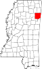
Towns Caledonia‡ | Hatley | Nettleton‡ | Smithville
Village Unincorporated
ommunitiesGhost towns Camargo | Cotton Gin Port
Footnotes ‡This town also has portions in adjacent county or counties
U.S. National Register of Historic Places Topics Lists by states Alabama • Alaska • Arizona • Arkansas • California • Colorado • Connecticut • Delaware • Florida • Georgia • Hawaii • Idaho • Illinois • Indiana • Iowa • Kansas • Kentucky • Louisiana • Maine • Maryland • Massachusetts • Michigan • Minnesota • Mississippi • Missouri • Montana • Nebraska • Nevada • New Hampshire • New Jersey • New Mexico • New York • North Carolina • North Dakota • Ohio • Oklahoma • Oregon • Pennsylvania • Rhode Island • South Carolina • South Dakota • Tennessee • Texas • Utah • Vermont • Virginia • Washington • West Virginia • Wisconsin • WyomingLists by territories Lists by associated states Other Categories:- Geography of Monroe County, Mississippi
- Ghost towns in Mississippi
- National Register of Historic Places in Mississippi
- Mississippi Registered Historic Place stubs
- Mississippi geography stubs
- United States ghost town stubs

Wikimedia Foundation. 2010.