- Lutherville-Timonium, Maryland
-
- Timonium redirects to here, for other uses see Timonium (disambiguation)
Lutherville-Timonium, Maryland — CDP — Location of Lutherville-Timonium, Maryland
Coordinates: 39°26′11″N 76°37′6″W / 39.43639°N 76.61833°WCoordinates: 39°26′11″N 76°37′6″W / 39.43639°N 76.61833°W Country United States State Maryland County Baltimore Area - Total 7.4 sq mi (19.1 km2) - Land 7.4 sq mi (19.1 km2) - Water 0.0 sq mi (0.0 km2) Population (2000) - Total 15,814 - Density 2,142.1/sq mi (827.1/km2) Time zone Eastern (EST) (UTC-5) - Summer (DST) EDT (UTC-4) ZIP codes 21093-21094 Area code(s) 410 FIPS code 24-48900 Lutherville-Timonium is a census-designated place (CDP) in Baltimore County, Maryland made up of the unincorporated communities of Lutherville and Timonium. The population was 15,814 as of the 2000 census. Within its borders lies the Lutherville Historic District. The Maryland State Fair is held in Timonium each year near Labor Day.
Contents
Geography
Lutherville-Timonium is located at 39°26′11″N 76°37′6″W / 39.43639°N 76.61833°W (39.436456, -76.618461)[1].
According to the United States Census Bureau, the CDP has a total area of 7.4 square miles (19.1 km²), all of it land.
The town is north of Baltimore City along I-83 and York Road. It is bordered on the north by Cockeysville and on the south by Towson.
Most residents consider Lutherville to be south of Ridgely Road, with Timonium extending from Ridgely Road north to Padonia Road. Some residents do not consider either Lutherville or Timonium to extend west past I-83; though most agree both communities are bounded by Dulaney Valley Road to the east.
Lutherville-Timonium is located in the Piedmont, and lies in the transition zone between the Humid subtropical climate zone to the south and the humid continental climate to the north, with hot and humid summers leading into winters that are cold but not extreme by American standards. The average annual snowfall is 25 inches (64 cm) and average annual rainfall is 42 inches (107 cm).
Transportation
Roads
Major roads in the Lutherville-Timonium area include:
- Bellona Avenue
- Deereco Road
- Dulaney Valley Road (MD-146)
- Ridgely Road
- Seminary Avenue (MD-131)
- Timonium Road
- York Road (MD-45)
Public transportation
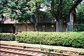
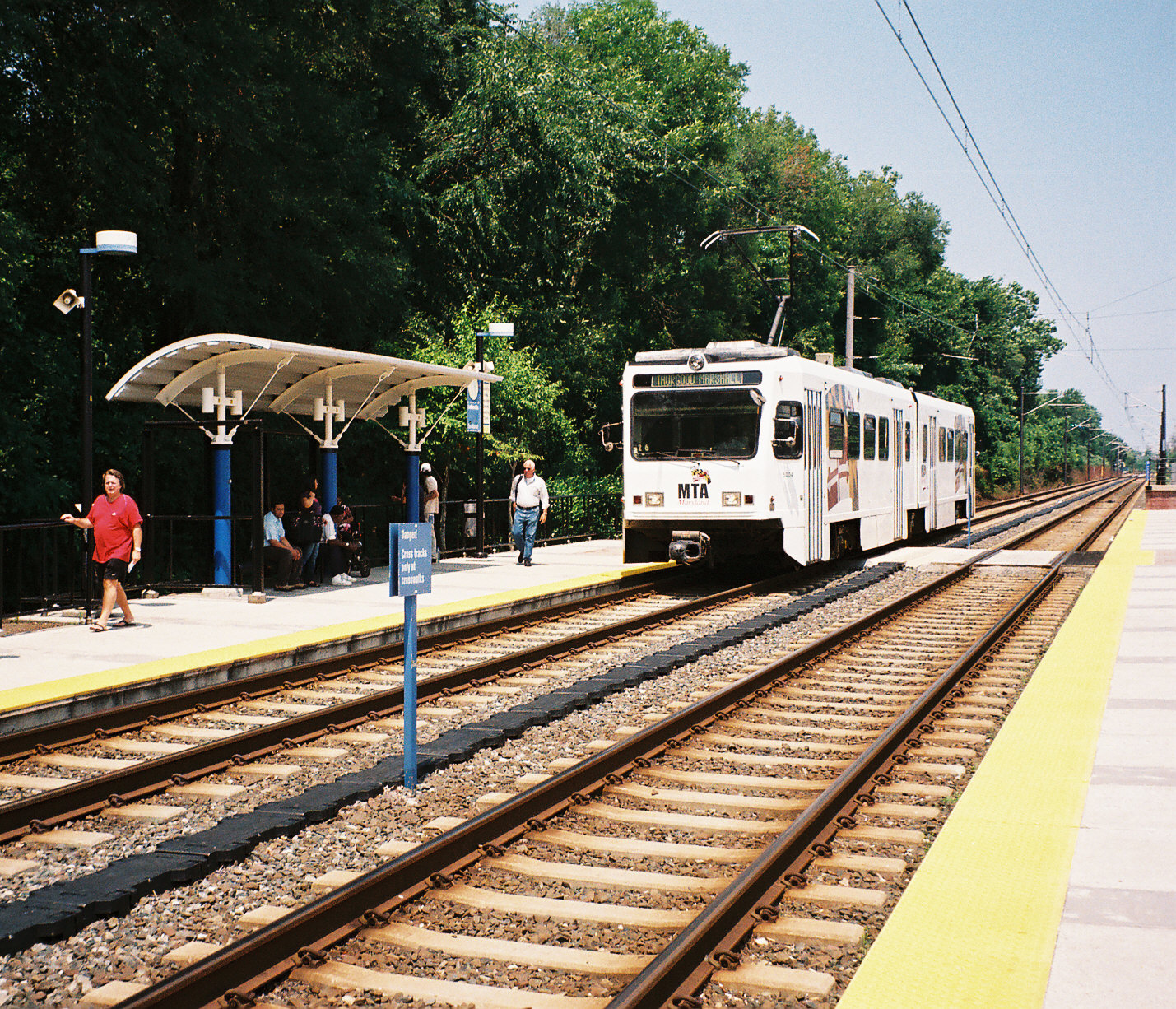
The Maryland Transit Administration's light rail line has three stops in the Lutherville-Timonium area: Lutherville, Timonium Business Park, and Timonium. In addition, bus routes 8 and 9 provide regular service along the York Road corridor, meeting at the Lutherville Light Rail Stop. There is also a limited amount of bus service on Bus Route 12 to along Dulaney Valley Road Stella Maris Hospice.
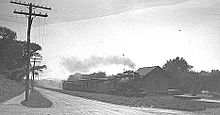
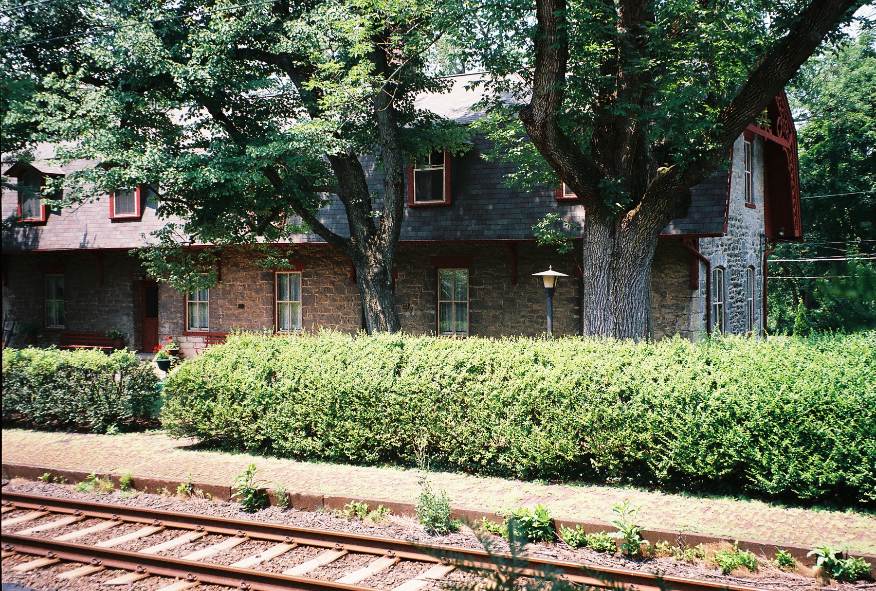
The MTA light rail line uses the right-of-way of the old Northern Central Railway (later, part of the extensive Pennsylvania Railroad system). During the Civil War, President Abraham Lincoln travelled through Lutherville on this railroad en route to Gettysburg, Pennsylvania, to deliver the Gettysburg Address on November 19, 1863. Less than two years later, on April 21, 1865, Lincoln's funeral train also passed through Lutherville on its way from Washington, D.C. to his final resting place at Springfield, Illinois.[2][3] The Pennsylvania Railroad (PRR) operated long-distance passenger trains from Baltimore over the line to Chicago, St. Louis, and Buffalo as late as the 1960s. The former PRR Lutherville freight and passenger station on Railroad Avenue is now a private residence.
Demographics
Historical populations Census Pop. %± 1960 12,265 — 1970 24,055 96.1% 1980 16,871 −29.9% 1990 16,442 −2.5% 2000 15,814 −3.8% source:[4] As of the census[5] of 2000, there were 15,814 people, 6,485 households, and 4,461 families residing in the CDP. The population density was 2,142.1 people per square mile (827.3/km²). There were 6,614 housing units at an average density of 895.9 per square mile (346.0/km²). The racial makeup of the CDP was 90.10% White, 3.22% African American, 0.15% Native American, 5.27% Asian, 0.01% Pacific Islander, 0.24% from other races, and 1.01% from two or more races. Hispanic or Latino of any race were 1.22% of the population.
There were 6,485 households out of which 24.7% had children under the age of 18 living with them, 59.4% were married couples living together, 7.1% had a female householder with no husband present, and 31.2% were non-families. 26.3% of all households were made up of individuals and 14.7% had someone living alone who was 65 years of age or older. The average household size was 2.36 and the average family size was 2.86.
In the CDP the population was spread out with 19.7% under the age of 18, 4.9% from 18 to 24, 24.6% from 25 to 44, 27.0% from 45 to 64, and 23.7% who were 65 years of age or older. The median age was 46 years. For every 100 females there were 90.1 males. For every 100 females age 18 and over, there were 87.5 males.
The median income for a household in the CDP was $61,573, and the median income for a family was $74,464. Males had a median income of $52,401 versus $35,132 for females. The per capita income for the CDP was $32,369. About 0.8% of families and 3.6% of the population were below the poverty line, including 0.6% of those under age 18 and 5.1% of those age 65 or over.
History

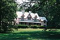
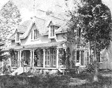 Oak Grove, the home of Lutherville founder John Morris, in 1872
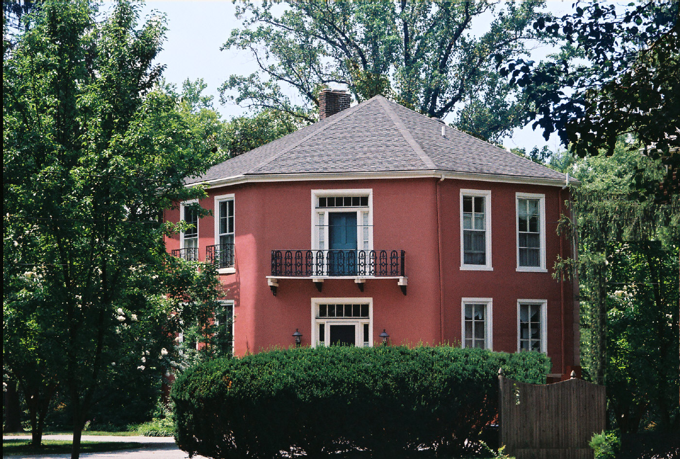
 Octagon House, built in 1855
The oldest section of Lutherville dates back to 1852, when it was founded by two Lutheran ministers as a planned community, anchored by a Lutheran seminary and church. The land was originally part of the vast Hampton Estate of Charles Ridgely, from whom it was purchased in 1851.[6]
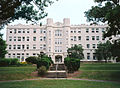
The two ministers, John Kurtz and John Morris, named the community after the 16th century German reformer, Martin Luther.[6] The Lutherville Female Seminary, as it was initially called when chartered in 1853, was built near the tracks of the Baltimore & Susquehanna Railroad, a forerunner of the Northern Central Railway. In 1895, the institution was renamed the Maryland College for Women. Following a devastating fire in 1911, the college was rebuilt and continued in operation until 1952. Its campus is now an adult congregate living facility, College Manor.
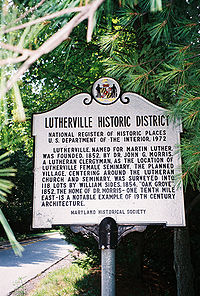
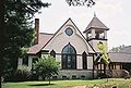
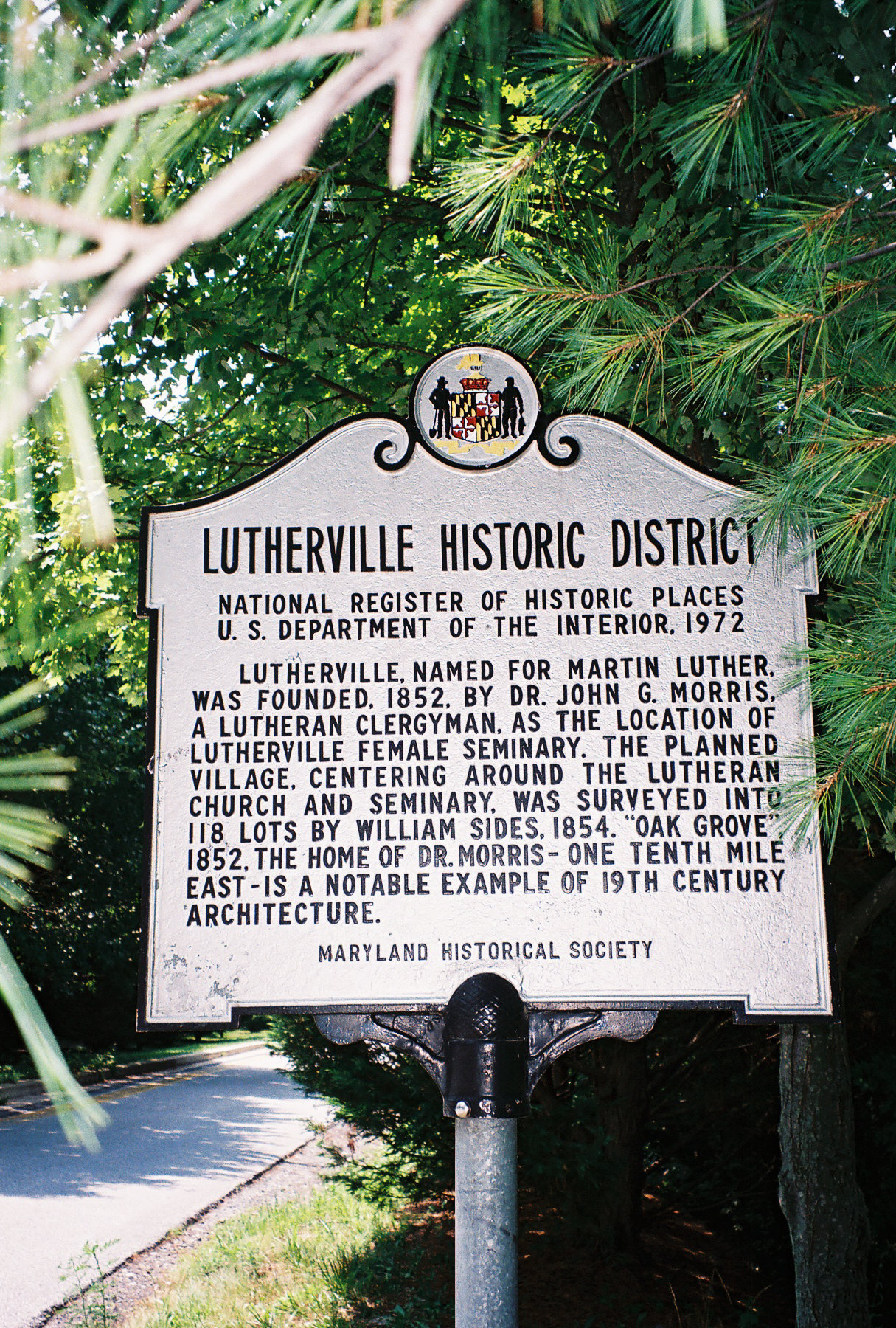
The Lutherville Historic District was added to the National Register of Historic Places in 1972.[6][7] Notable structures, in addition to the old college building and the many Victorian homes, include:
- St. Paul’s Lutheran Church, started in 1856 by John Morris. The present stone sanctuary was built in 1898.
- St.John’s Methodist Church, built in 1869.
- Church of the Holy Comforter, an Episcopal church built in 1888
- Oak Grove, the house of Lutherville founder John Morris, built in 1852 on Morris Avenue
- Octagon house on Kurtz Avenue, built of concrete in 1855 by another Lutheran minister who also served as the town's postmaster.
Also listed on the National Register of Historic Places are the Green Spring Valley Historic District and Western Run-Belfast Road Historic District.[7]
Notable people
- Former U.S. Vice President Spiro Agnew is buried in Timonium.
- The pop punk band All Time Low are from Lutherville.
- Tennis player Pam Shriver and swimmer Beth Botsford grew up in Timonium.
- Former Baltimore Colt and Hall of Famer Johnny Unitas once lived in Lutherville and is buried at Dulaney Valley Memorial Gardens in Timonium.
- Former Baltimore Orioles Jim Gentile, Gus Triandos, and Mark Belanger lived in Timonium. Triandos Drive is named in honor of the popular Orioles catcher of the 1950s.
- Former major league baseball shortstop and manager Billy Hunter lives in Lutherville.
- Former major league baseball pitcher Bob Turley lived in Lutherville.
- Former major league baseball first baseman Rafael Palmeiro lived in Lutherville when he was a member of the Baltimore Orioles.
- Former Baltimore Orioles and Hall of Famers Brooks Robinson and Jim Palmer lived in Lutherville.
- Former Baltimore Colts Dick Szymanski and Don Shula (later coach of the Miami Dolphins) lived in Timonium.
- Singer-songwriter Cheryl Wheeler was born in and grew up in Timonium.
- Astronaut/physicist Samuel Durrance lived in Lutherville.
- Filmmaker John Waters grew up in Lutherville.
- Actor Divine grew up in Lutherville.
- Professional lacrosse players Conor Gill and Ryan Boyle are from Lutherville.
- Rock band Cinder Road are from Lutherville.
- Internet engineer Phil Karn was raised in Lutherville.
- J. Frederick C. Talbott, U.S. Congressman 1878–1918.
- Television news anchorman Jerry Turner, Baltimore Colts Hall of Famer Raymond Berry, and businessman James G. Howes, lived in the Dulaney Village neighborhood of Lutherville.
- Mike Singletary lived in Lutherville when he was with the Baltimore Ravens.
- Major League Baseball player Mark Hamilton formerly lived in Lutherville.
- New York Times film critic Bosley Crowther was born in Lutherville.
Education
- Public schools
- Hampton Elementary School
- Lutherville Laboratory Elementary Magnet School
- Pinewood Elementary School
- Pot Spring Elementary School
- Timonium Elementary School
- Ridgely Middle School
- Dulaney High School
- Riderwood Elementary School
A portion of Lutherville's high school-age students attend nearby Towson High School. Other institutions of higher learning in nearby Towson are Towson University and the Peabody Conservatory's Preparatory School.
Gallery
- Images of Lutherville
-

Lutherville Light Rail station
-
Former Pennsylvania Railroad station
-
Oak Grove in 2009
-
St. Paul's Lutheran Church
-
Former Maryland College for Women
References
- ^ "US Gazetteer files: 2010, 2000, and 1990". United States Census Bureau. 2011-02-12. http://www.census.gov/geo/www/gazetteer/gazette.html. Retrieved 2011-04-23.
- ^ Daniel Carroll Toomey (1997). Baltimore During the Civil War. Toomey Press. pp. 170. ISBN 0961267070.
- ^ "The Route of Abraham Lincoln's Funeral Train". 1996-12-29. http://rogerjnorton.com/Lincoln51.html. Retrieved 2008-04-15.
- ^ "CENSUS OF POPULATION AND HOUSING (1790-2000)". U.S. Census Bureau. http://www.census.gov/prod/www/abs/decennial/index.html. Retrieved 2010-07-17.
- ^ "American FactFinder". United States Census Bureau. http://factfinder.census.gov. Retrieved 2008-01-31.
- ^ a b c "Lutherville, Maryland a Victorian Experience". Baltimore County Public Library. January 25, 2008. http://www.bcplonline.org/info/history/hist_local_lutherville.html. Retrieved 2009-07-19.
- ^ a b "National Register Information System". National Register of Historic Places. National Park Service. 2008-04-15. http://nrhp.focus.nps.gov/natreg/docs/All_Data.html.
Categories:- Populated places in Baltimore County, Maryland
- Census-designated places in Maryland


Wikimedia Foundation. 2010.